Urban Volcanoes | Dreamworlds

Sometime during my 2017 travels around Iceland I had a dream about a cluster of volcanic cones and craters in an urban park. It was after my visit to Vestmannaeyjar (see my previous post) so was likely influenced by the volcanoes there, but these imaginary ones were closely hemmed in by city streets and set among manicured lawns.

Watercolor painting with contour lines on laser-etched plexiglass overlay, depicting surreal dream-inspired landscape of volcanoes and craters in volcanic urban park.

Community Crater Cluster, watercolor on paper and oil pen on plexiglass, 15”x20.”

Community Crater Cluster, one of the works I began during my Iceland artist residency in the period when I’d started working in watercolor but not yet in the fractured style, grew out of that dream. I had to extrapolate a great deal and solidify what had been only very vague impressions—my geography-themed dreams can be really thorough but in this one I remember standing in only one spot, in the lower left corner of the park looking up toward the summit of the cone with the path crossing over it. The larger, “half volcano” at the far right is the only piece I borrowed directly from reality, specifically Vestmannaeyar, rather than some combination of the dream and later imagination. The baseball diamond, though, replaced what’s actually a golf course, being a better fit for the radial form of the crater.

Bicycle path through volcanic crater on the island of Heimaey in Vestmannaeyjar, Iceland.

Entering the “half volcano” on Vestmannaeyjar.

This work was the basis for a newer one, Community Crater Cluster II, which intersperses landscape views with bird’s-eye fragments as in all my recent worldviews. Except for the volcano taken from Vestmannaeyjar, obviously I didn’t have any of my own photography to work from, but luckily I could overlay my mental images on some photos of my hilly San Francisco neighborhood to set up somewhat realistic perspectives. (Though given that it’s all based on a dream, I still allowed myself some liberties there.) The central fragment, with the wrought-iron fence and the long stairway up to the crater, represents the view I remember from the dream—from what might’ve been a cemetery at the base of the volcano. The overall composition, made up of fragments that are more triangular than I typically use, was inspired by the volcanic cones as well as the concept of “view cones” (representing the direction and extent of views from particular vantage points on a map.)

Abstract cartographic watercolor painting depicting surreal dream-inspired landscape of volcanoes and craters in volcanic urban park.

Community Crater Cluster II, watercolor on paper, 36”x45.”

Village Volcano is another work, on a similar urban park theme, that was inspired by a dream—this one a few weeks before leaving on the Iceland trip when I must’ve already had volcanoes in my head. I did a lot more exploration in this dream, to the extent that I had a nearly complete park designed in my mind when I went to put in on paper (also during the residency). In contrast to the first dream, in this case I remember the single crater being hard to find, surrounded by relatively gentle slopes (nearly flat on the left side) rather than situated at the top of a cone, and competing in prominence with a dry, rocky canyon that must’ve been more influenced by California scenery. And, not only is the crater juxtaposed with urban elements, like sports fields, as in other examples I’ve talked about; there’s even architecture built right into the crater walls, as mundane as a food court/shopping center if I remembered it right. So the urban-wild interface in this case is accentuated less by a striking overall contrast between urban and volcanic landscapes than by the element of surprise created by intermingled elements of both.

Watercolor painting with contour lines on laser-etched plexiglass overlay, depicting surreal dream-inspired landscape of volcanic urban park.

Village Volcano, watercolor on paper and oil pen on plexiglass, 15”x20.”

As with Community Crater Cluster my plan is to re-interpret Village Volcano in the fractured style. But I’m thinking that, for the first time since leaving the plexiglass overlays behind, I might experiment with incorporating the topographical lines (with pen directly on paper). Given the gentle slopes, it would otherwise be too hard to read the radial form of the volcano. Stay tuned!

Darren

Urban Volcanoes | Vestmannaeyjar

A few weeks before my July 2017 artist residency in Laugarvatn, Iceland, I spent a few days on the offshore island of Heimaey in the mini-archipelago of Vestmannaeyjar (also known as the Westmann Islands) southeast of Reykjavik and a short ferry ride from the mainland. Vestmannaeyjar is one of the country’s many active volcanic zones; it includes the island of Surtsey, formed only in 1963, and on Heimaey the volcanoes Eldfell and Helgafell which have inspired two recent worldviews. (Incidentally the double “l” in Icelandic is usually pronounced “tl.”)

Village and red volcanic cones of Eldfell and Helgafell on the island of Heimaey in Vestmannaeyjar in Iceland.

Eldfell (left) and Helgafell in the background, looming over the village.

Craggy volcanic topography of the island of Heimaey in Vestmannaeyjar, seen from the Ring Road in Iceland.

Jagged profile of Heimaey in the distance, seen from the Ring Road near the southern coast of the mainland. (The island has a lot of dramatic topography aside from the volcanoes.)

Reddish volcanic cone of Eldfell, seen from adjacent volcano of Helgafell, on the island of Heimaey in Vestmannaeyjar in Iceland.

Eldfell seen from the summit of Helgafell. Located on the outskirts of a village rather than a major city, these volcanoes are less strictly “urban” than those in Auckland, but they don’t feel at all remote.

I rarely buy souvenirs anymore, but I was tempted by these volcano hats….

I rarely buy souvenirs anymore, but I was tempted by these volcano hats….

Heimaey is the largest and only inhabited island in the archipelago, with a population of about 4,000. On January 23, 1973, the volcanic vent that was to soon to become Eldfell (“Fire Hill”) without warning began erupting fountains of lava in a resident’s backyard. The entire population of the island was safely evacuated and the lava flows were slowed by water hoses, but a large portion of the village was buried in lava and ash, and at the end of the five-month eruption about a square mile (a quarter of the island’s area at the time) of new land had been added. Today, the majority of Heimaey’s population has returned, and Eldfell is a dark 200m-high cinder cone looming over the village.

For reasons I went into in my last post on volcanoes in the city of Auckland, small volcanic cones in human settings fascinate me; I was particularly drawn to the tension between Eldfell’s “domesticated” quality (its accessibility plus its backyard origins) and such recent evidence of its destructive power. Home Island below, named for the English translation of Heimaey (there’s something inspiring about the island’s population returning home to a place now so strongly defined by an active volcano), captures this strange and slightly ominous juxtaposition of volcano and village. The work includes one small fragment, near the center, recalling the eruption itself—the first instance that I’ve played with fracturing time in addition to space.

Abstract cartographic watercolor painting on aquabord of the active volcano Eldfell on the Island of Heimaey in Vestmannaeyjar, Iceland.

Home Island, watercolor on aquabord, 24”x36,” inspired by Eldfell.

Abstract cartographic watercolor painting on aquabord of the volcano Helgafell on the Island of Heimaey in Vestmannaeyjar, Iceland.

Sacred Hill, watercolor on aquabord, 30”x22,” inspired by Helgafell. The triangle of brown in the lower left is the summit of Eldfell.

Heimaey’s second volcano, Helgafell (“Sacred Hill”), is located a short walk away from Eldfell and rises to about the same height. It formed about 5000 years ago and is dormant, but its juxtaposition with the village is still striking—seen from town its profile is more perfectly conical than Eldfell, the top few meters are still bare gravel and boulders, and the trail to the summit begins randomly between a farmhouse and a soccer field. The sensation of the island spiraling around the volcano in the worldview wasn’t planned, and in real life Eldfell is much more the center of attention because of its newness to the scene. But I found Helgafell at last equally alluring, probably because it’s been pushed into the background by its more famous neighbor and yet could one day erupt again.

Darren

Urban Volcanoes | Auckland Volcanic Field

My last series of posts focused on how islands are particularly good subjects for the worldviews because their smallness, boundedness, and isolation make them easy-to-grasp, empowering microcosms of the wider world. The islands I described are all surrounded by water, but islands in the less literal sense—surrounded and defined by any type of contrasting environment—can have the same effect, and I can’t think of any place I’ve depicted that doesn’t involve some form of island.

This next set of posts will go back to a topic I’ve dealt with before, another type of island—“wild” places surrounded by “civilization.” Without re-hashing my rabbit hole of a discussion on what I mean by those terms (my Realities of Nature posts), I think anyone would agree that the “inhuman-ness” of natural environments often goes beyond simply lacking a human presence to having a mysterious, sinister or even subtly hostile quality. In my Páramo post I make specific reference to it, but any time I depict or talk about surreal plants or landscapes there’s probably an element of threat that helps to set that place apart. That many of us are attracted to such places relates to the concept of the sublime—a library’s worth of landscape and art historical theory that I won’t get into, but basically it’s the idea that we find it invigorating to be in the presence of danger that can’t actually harm us.

Standing on the edge of the Grand Canyon (behind a guardrail) or below Half Dome would be an example of a sublime experience. But also part of this aesthetic tradition, as it’s been applied to landscape architecture, is the shrinking and encircling of landscapes otherwise truly threatening in their boundlessness in order to reduce that hostility to something more superficial and poetic. (Think the Ramble in Central Park—a zone of unmaintained, unrestrained forested hills and cliffs surrounded by a more manicured, urban landscape. It carries wilderness associations for sure, but the only real dangers are of the urban kind.) I think my own impulse to shrink and encircle nature in two dimensions could be interpreted along the same lines.

Volcanoes are probably the best examples of threatening natural features or phenomena that many find fascinating both because of and in spite of their destructive power. It’s the miniature ones that I’m most drawn to, whether in real life or ones that I’ve imagined, because while that power is still evidenced by the volcanic form, it feels “tamed” or “humanized.” And I find this humanization to be strongest and most empowering when surrounded by human-dominated landscapes, especially urban.

Auckland, New Zealand. Many of the scattered green patches are remnants of volcanic cones, now mostly public parks.

Auckland, New Zealand. Many of the scattered green patches are remnants of volcanic cones, now mostly public parks.

Here I’ll get into two real-world urban volcanoes that have inspired worldviews in which I’ve accentuated the urban-volcanic interface. Both are in Auckland, New Zealand, among the fifty or so making up the Auckland Volcanic Field. Many have been quarried away but they include a number of cones and lakes, some still active, and most now public open spaces. The most recent eruption was Rangitoto, an island a short boat ride from downtown, that rose from the gulf (to 260m) just 600 years ago (sorry, I guess I wasn’t fully done yet with islands in water as I promised last time).

Rangitoto has the added interest of being very intact and diverse ecologically, with the world’s largest pohutukawa forest (a common street tree and a relative of Hawaii’s ohi’a) covering the rocky lower slopes and more rainforest-like vegetation on the upper slopes and in the crater. Its wildness in the geological as well as ecological sense, contrasted with its manageable scale (the easy hike to the crater takes less than an hour) and proximity to the city made Rangitoto one of the highlights of my 2017 trip to New Zealand, even on par with the multi-day wilderness treks.

Pōhutukawa forest on the volcanic island of Rangitoto in Hauraki Gulf near Auckland, New Zealand.

Looking toward the summit of Rangitoto from the lower slopes.

View of Auckland, New Zealand, from the summit of the volcanic island of Rangitoto in Hauraki Gulf.

View toward downtown Auckland from the crater rim.

View of the volcanic island of Rangitoto in Hauraki Gulf from Devonport in Auckland, New Zealand.

Rangitoto seen from the northern suburbs of Auckland.

Some tourist information on Rangitoto hikes and natural history.

Some tourist information on Rangitoto hikes and natural history.

Harbour Island, abstract watercolor painting of the volcanic island of Rangitoto in Hauraki Gulf in Auckland, New Zealand.

Harbour Island, watercolor on paper, 18”x18,” inspired by Rangitoto. To accentuate the urban-wild contrast I’ve relocated the island closer to the center of the city.


The second Auckland volcano that has so far inspired a worldview (I visited about 8 in total) is Mt. Wellington—a typical grassy urban park, with picnic tables and athletic field, except for the deep crater in the middle. My guess is that it was once shrub-covered, and that the grasses are all European invasives, so I’ve learned that for me the presence of a crater can make up for the absence of ecological interest. (Normally, unless there’s design interest or a unique urban context, open spaces without relict or restored native vegetation don’t excite me much.)

Darren

Grassy volcanic crater of Mt. Wellington, an urban park in Auckland, New Zealand, on a foggy, rainy day.

View across the crater of Mt. Wellington on an icky day.

Picnic tables by the grassy volcanic crater of Mt. Wellington, an urban park in Auckland, New Zealand, on a foggy, rainy day

View across Mt. Wellington from the opposite side (the crater is in front of the hills in the background, obscured from this perspective).

Domain, an abstract cartographic watercolor painting inspired by Mt. Wellington, a volcanic crater in an urban park in Auckland, New Zealand.

Domain, watercolor on paper, 20”x20,” inspired by Mt. Wellington. The tree ferns are idealizations, reflecting some of what I imagine to be the original vegetation. The title comes from the fact that public parks in Auckland are known as “domains” (maybe a reference to how the land was set aside), a term that also brought to mind the quiet but still dominant presence of the volcano.


Islands | The Jewel Series

Two of my recent posts dealt with imaginary islands made up of pieces of real places. This post will be a sort of coda to those discussions, wrapping up the invented island theme (for now at least) by sharing a few more worldviews based on some of those same locales.

One of the works in those earlier posts was Pearl Islands, inspired by coastal northwest Australia and so titled because the pristine, precious quality of the islands it depicts (with glimmering white sands) was reminiscent of the pearls that the region is known for. That got me thinking more generally about portraying priceless, endangered islands like gemstones, each with a particular dominant hue, maybe even incorporating materials that I’d never otherwise consider using like gold leaf and ornate metallic frames. That last part fell by the wayside, but the gemstone idea did produce three worldviews that I informally call my “Jewel Series.” All are only 10” square in order to underscore the themes of preciousness and vulnerability.

Below are those three islands, each one following some additional photos from the real-world places that inspired them. For more detail on those places and how I re-imagined them, check out my earlier posts on Ecuador and the Kimberley region of Northwest Australia.

Darren

Mangroves, red rocks and earth, tidal flats, and turquoise sea near Broome, northwest Australia

Mangroves and tidal flats south of Broome, Western Australia.

Dramatic color contrast of red rocks and earth against turquoise sea, coast of northwest Australia near Broome

Coastal hues north of Broome.

Darren Sears artist selfie with white baobab tree (Adansonia gregorii) in Keep River National Park in the Kimberley region of Western Australia.

Baobab (Adansonia gregorii) in Keep River National Park, Northern Territory.

Pearl Isle, abstract miniature watercolor painting of baobab trees, pandanus and mangroves along the coast of the Kimberley region of Western Australia.

Pearl Isle, watercolor on paper, 10”x10.”

View from a scenic flight over colorful sandstone beehive landforms in the Bungle Bungles, or Purnululu National Park, in the Kimberley region of Australia

Sandstone “beehive” formations in the Bungle Bungles (Purnululu National Park), Western Australia.

Baobab tree, Adansonia gregorii, in golden grassland near Kununurria in the Kimberley region of Western Australia

Another baobab near Kununurra, Western Australia.

Towering Livistona victoriae fan palms and eroded red sandstone cliffs in Keep River National Park in the Kimberley region of Western Australia

Livistona victoriae palms in Keep River National Park, Northern Territory, Australia.

Amber Isle, abstract miniature watercolor painting of baobabs, surreal landforms, and palm oasis at sunset inspired by Kimberley region, Australia.

Amber Isle, watercolor on paper, 10”x10.”

Lush primary cloud forest in Los Cedros Reserve, northern Ecuador

Primary (virgin) cloud forest in Los Cedros Reserve, northwest Ecuador.

Flowering green tree, Ceiba trichastandra or ceibo, in dry forest along the coast of Ecuador

Floweringceibo” (Ceiba trichastandra) in dry forest along the central Ecuadorean coast.

Green tree, Ceiba trichastandra or ceibo, in the dry forest near the coast of Ecuador

Ceiba trichastandra—not quite as “emerald”-like as painted, but still strikingly green. Except for the buttress roots it looks a lot like a green baobab, and is in fact in the same family.

Emerald Isle, abstract miniature watercolor painting of imaginary Ecuador-inspired rainforest and dry forest landscapes on an island.

Emerald Isle, watercolor on paper, 10”x10.”

Shark Fin Island

This post will stay on the the topic of imaginary islands, but the island in question is different in two ways from those I’ve shared so far. First, not only is this island made up, but its components are too; it isn’t an idealization of a place I’ve visited or an aggregate of multiple real places. And second, I created it during the period when I was transitioning from oil to watercolor and hadn’t yet begun working with the fractured style in the latter, so it consists of a series of separate images rather than a single composition combining multiple views. But as you’ll see, in one sense it represents a worldview more than anything else I’ve created to date.

I invented Shark Fin Island for a competition in the LA+ Interdisciplinary Journal of Landscape Architecture (out of UPenn), calling for entrants to design their own islands. The narrative (italicized) and images below should be self-explanatory, but to summarize, Shark Fin is perfectly situated at the confluence of multiple biogeographic realms, and the island’s steep topography creates climatic conditions enabling species from each of them to coexist in an area of less than a square kilometer (the maximum size allowed by the competition brief).

Shark Fin Island.jpg

Shark Fin Island, named for its distinctive profile rising dramatically out of the mid-North Atlantic at the latitude of Nova Scotia, is the heavily-eroded product (along with surrounding seamounts) of a volcanic hotspot. Straddling climatic and biogeographic boundaries, sufficiently isolated to boast 95% plant endemism, ecologically diverse despite covering slightly less than a square kilometer, and essentially free from human impacts, many consider it to be the planet’s most unique assemblage of plants and ecosystems.

The warm waters of the Gulf Stream extend the subtropical zone northward to Shark Fin Island. This, combined with its location midway between North America and Europe, situates the island at the convergence of the Nearctic (northern New World), Palearctic (northern Old World), and Neotropical (tropical New World) Realms, each contributing evolutionary raw material transported by birds. Furthermore a striking precipitation gradient, produced by steep topography that intercepts the prevailing westerlies, has enabled colonization by plant species from a variety of climates. The lowland forest, receiving 1200mm of rainfall annually at sea level, is dominated by species with origins in Bermuda, along with contributions from subtropical North America. The montane forest, with an annual rainfall of up to 2100mm, resembles the cloud forests of the Azores and is composed primarily of species originating there (with additions from Europe, temperate North America, and Caribbean cloud forests).

Isolation, topography and a paucity of edible fauna have protected the island from exploration, settlement, and invasive species; today, access is restricted to researchers. But its environment, created by a delicate balance of topographic, oceanic and atmospheric factors, is highly vulnerable to climate change. Overall precipitation is predicted to decrease, resulting in eventual disappearance of the already restricted montane forest, along with significant impacts at lower elevations. Accelerated efforts are underway to catalogue the island’s biota while it remains intact.

Sketch 3D model of a steep, exotic imaginary island.

A few shots of a 3D model that I ended up not developing further for the competition, but it was useful as a starting point for the drawings below.

Shark Fin Island, an exotic imaginary island depicted in a watercolor painting.

Plan, Shark Fin Island, watercolor-on-paper original (22”x22”) with digital overlay.

Watercolor cross-section of imaginary Shark Fin Island.

Cross-section (location marked in red on the Plan above), watercolor-on-paper original (13”x22”) with digital overlay.

Shark Fin Island3a.jpg
Shark Fin Island3.jpg

I should emphasize that the idea of a subtropical island at the latitude of Nova Scotia isn’t at all fantastical given that it’s also the latitude of northern Spain. What seems unlikely is such an island existing as far west as I’ve located it, because no islands exist in that region to define the climatic boundary between temperate North America and Gulf Stream-moderated Europe. (Whether the latter is technically temperate or subtropical depends on how you define the terms.) But I’ve always wondered where that sweet spot is—just easterly enough to be strongly influenced by the Gulf Stream but still close enough to northern North America to be surprising. (Bermuda, in line with the Carolinas, could be considered the equivalent for a tropical island, though that “tropical” designation is borderline.)

Watercolor painting of lush cloud forest on the imaginary Shark Fin Island

Watercolor-on-paper original (14”x22),” with view location shown in red on the key plan in the upper left. Note that the plants in the description are invented as well.

Watercolor painting of dry forest on the imaginary Shark Fin Island.

Watercolor-on-paper original (14”x22)”.

As I’ve explained before, a primary motivation behind the worldviews is imparting a sense of control or omniscience over a place—like the empowering feeling of taking in the sweeping vista from a mountaintop—by merging multiple facets of that place into a single experience. All of the locales I depict are “world-shrinking” like this to varying degrees, but so far Shark Fin Island is the only one to draw in influences across a scale anything approaching the entire world. Merging elements of far-flung places into close proximity is something I’d like to investigate further though. That means representing Shark Fin Island in the fractured style at some point, but also depicting real places (islands or otherwise) where this type of integration happens.

In fact such places are common. Continent- or planet-scale transitions are never completely smooth—variety in local conditions means that at a finer-grain, these gradients are in fact made up of discrete, intermingling “patches” of contrasting environments. Enlarging small segments of a gradient reveals often-sharp boundaries between these patches, though zooming back out on a map or traveling along the gradient by car (or of course by plane) they disappear into a blur. I’ve visited a few good examples of such boundary zones, including the Big Thicket in southeast Texas, where elements of northeastern temperate forests, southeastern subtropical forests, and western deserts are juxtaposed; and Lamington National Park in Queensland, Australia with relict patches of southern temperate species isolated within subtropical rainforest.

A worldview depicting a boundary zone like this would ideally include its larger transitional context as well. I do find larger-scale gradients exciting in their own right if they can be experienced in an unbroken journey on the ground. Maybe it’s by virtue of the very fact that such transitions over hundreds or thousands of miles can actually be traveled in days rather than months, “world-shrinking” by compressing time rather than space (seeing it by air is exciting too, but you of course sacrifice depth of experience for additional speed).

Darren

Islands | Imagined (cont.)

In my last post I introduced a few worldviews depicting imaginary islands, as opposed to most of my more recent works that have focused in on real places. Here I’ll continue where I left off.

Though I’m always trying to draw attention to today’s environmental challenges by showing the types of places we have to lose, even if the specific locales don’t actually exist to begin with, at the same time I do try to offer at least some temporary escape from those realities through visual experiences of what’s left or what once was. (At least, I’d like to think that these two goals can coexist.) Given the added anxiety and uncertainty that’s suddenly descended upon us, hopefully these ideas and images can provide a refuge in more ways than one.

Flinders Island, Australia

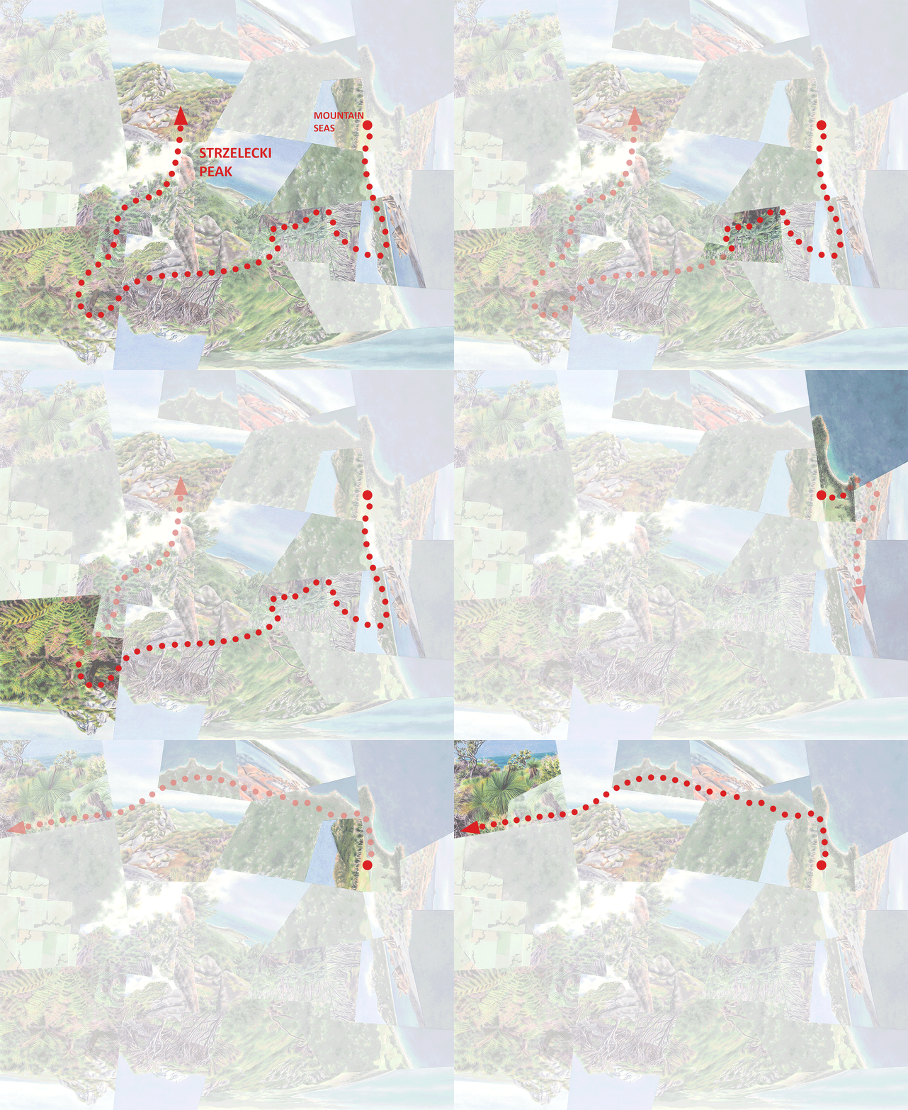
One of my earliest posts delved into my 2017 artist residency on Flinders Island, off the northeast corner of Tasmania. My focus there was Strzelecki National Park, which incorporates a fascinating diversity of endangered coastal and mountain habitats that inspired Sanctuary, my very first fractured composition in watercolor.

Off the coast of Flinders are several much smaller islands including the 125-hectare Big Green Island—a nature preserve known for its nesting bird populations and where invasive rats were recently eradicated. The island’s vegetation, from what I can tell, is relatively uniform and likely very degraded. But, from my experiences in nearby Strzelecki National Park combined with my obsession with ecological zonation patterns, I re-imagined it as rising to higher elevations with arid lowlands and a wet ferny summit.

Big Green Island off the coast of Flinders Island, Tasmania

Big Green Island, off the southwest coast of Flinders, seen from the summit of Mt. Strzelecki. (I didn’t visit the island itself.)

Lush rainforest gully with tree ferns on the hike to Strzelecki Peak on Flinders Island, Tasmania.

Tree ferns, Dicksonia antarctica, on the hike up Mt. Strzelecki.

Grass tree, Xanthorrhea australis, near Strzelecki National Park on Flinders Island, Tasmania.

Grass tree, Xanthorrhea australis, along the southern coast of Flinders Island.

Islet, abstract watercolor painting of an imaginary island with desert and tree ferns.

Islet, watercolor on paper, 18”x24,” inspired by Big Green Island (its outline that is—everything else is invented)

Ecuador

A few of my earlier posts described the surreal páramo (alpine moorland) and polylepis forest of El Angel Reserve, Ecuador, and two works based on it (Páramo and Lagoon). On that trip on 2018 I also visited Machalilla National Park along the central coast of the country, protecting a piece of endangered dry forest transitioning between the rainforests to the north and the deserts to the south; and the primary (i.e. never cut) cloud forest of Los Cedros Reserve on the western slope of the Andes. (This trip also included the Gálapagos Islands, which I’ve posted on a few times as well.)

These semi-arid, rainforest and alpine environments are hundreds of kilometers apart, but Ghost Isle below incorporates them into a single imaginary island. (You could say that the island part brings the Gálapagos portion of the trip into the work as well.)

Blue columnar Pilosocereus cacti in the dry forest of Machalilla National Park, Ecuador

Pilosocereus cacti in Machalilla National Park along Ecuador’s central coast.

Lush streamside rainforest in Los Cedros Reserve in Ecuador

Rainforest in Los Cedros Reserve.

Waterfall at treeline in El Angel Ecological Reserve, Ecuador

Upper reaches of the forest at the edge of the páramo, El Angel Reserve.

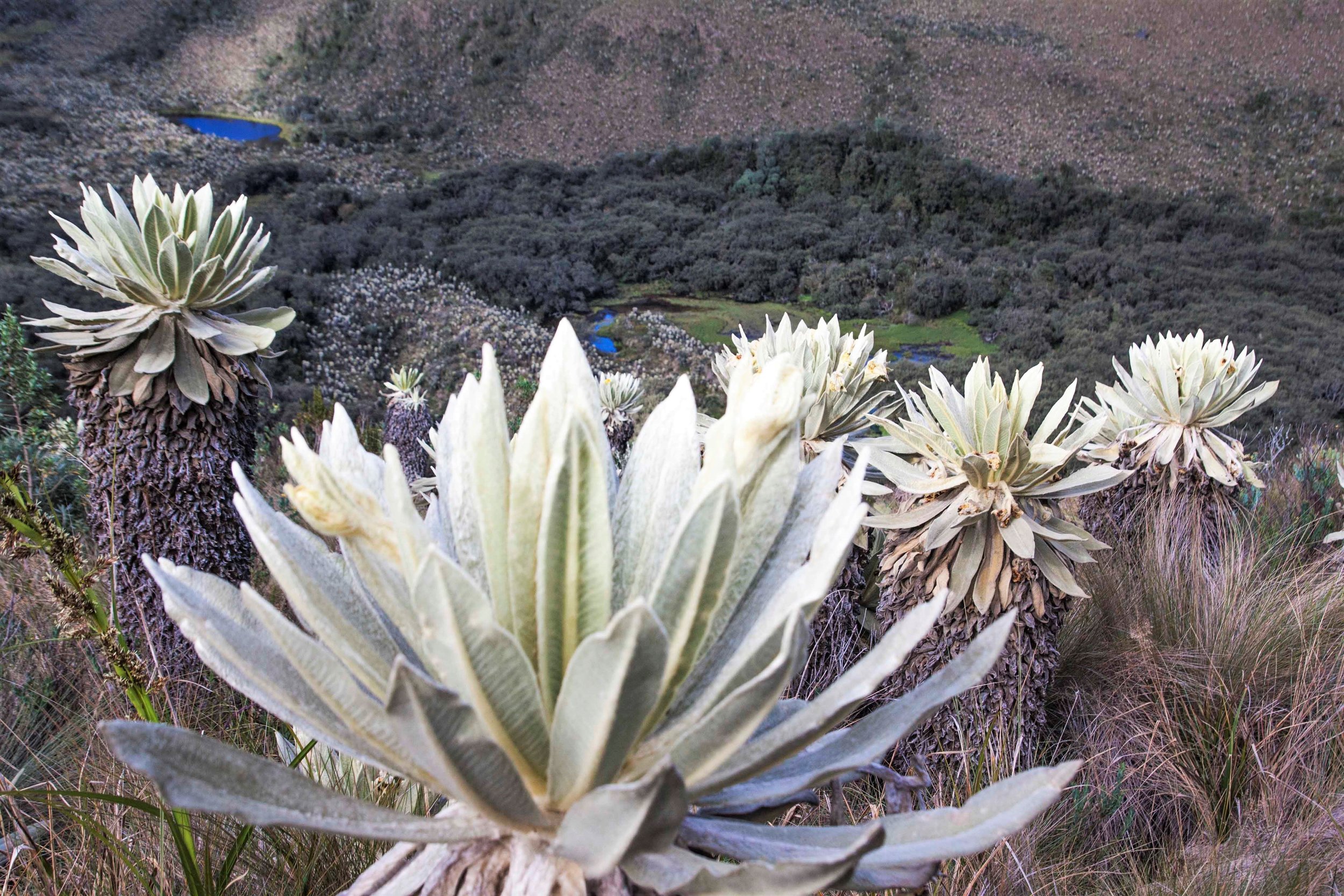
Surreal landscape of frailejones (Espeletia pycnophylla) at Voladero Lagoon in the paramo of El Angel Ecological Reserve, Ecuado

Frailejones (Espeletia pycnophylla) above Voladero Lagoon, El Angel Reserve.

Ghost Isle, abstract watercolor painting of an imaginary island inspired by rainforest, paramo and dry forest in Ecuador

Ghost Isle, watercolor on paper, 15”x17.”


Stay healthy everyone, and take this opportunity to be mentally “present” or “far away” as you choose—I’m always much better at the latter! But I’ll end this post with the here-and-now: some shots from the March 7 Artist Reception for Fractal Plein. (It is still on the walls, though the “now” part is in name only given that everything non-essential in the Bay Area has closed for at least the next three weeks….)

Darren

Fog Meadows, watercolor on paper, inspired by the Lomas de Lachay in Peru. at the Artist Reception for an exhibition at Hang Art Gallery in San Francisco
Watercolor paintings inspired by Iceland and Peru at the Artist Reception for an exhibition at Hang Art Gallery in San Francisco
Watercolor painting inspired by the Canary Islands at the Artist Reception for an exhibition at Hang Art Gallery in San Francisco
Watercolor painting inspired by Iceland in the window of Hang Art Gallery in San Francisco

Islands | Imagined

My last few posts dealt with representations of real islands (two in the Galápagos and two in the Canaries) idealized to varying degrees; these next few will look at islands that are completely invented, based on pieces of real places. I’ve been creating fewer of these imaginary worldviews recently, partly because of an increased conservation-oriented message and partly because I find it a more exciting challenge to integrate a locale’s multiple facets in a way that corresponds to my actual experience of how they relate to one another. But my fractured style began (in photomontage) with imaginary places, and I expect I’ll cycle back there every so often.

Though the following works aren’t inspired by individual sites, they do each draw from particular regions or locales, and I’ve categorized them that way below.

The Kimberley, Australia

The first two worldviews are based on parts of the Kimberley region of northwest Australia that I didn’t visit but wish I had; so, the sites they depict are imaginary in that they’re cobbled together from my experiences of nearby places. But they’re also imaginary because the real places aren’t actually islands. As I’ve done in other instances, I’ve surrounded them by water in order to accentuate the sense of distinctiveness that I find empowering with all small islands, real or not.

The interior of The Kimberley is characterized by arid mountains and grasslands, broken by the occasional palm-filled gorge or oasis. The most iconic area is probably the Bungle Bungles (in Purnululu National Park)—sandstone formations described as “beehive” due to their weathered, rounded forms and colorful striations. I arrived in the area in mid-October just as tours were closing down due to the hot weather, but luckily I decided to splurge on a scenic flight.

Aerial view of sandstone beehive formations in the Bungle Bungles, or Purnululu National Park, Western Australia, from a scenic flight.

Airplane view of the Bungle Bungles.

Tiger Island integrates the beehive landforms with an interior palm oasis and “coastal” grasslands filled with baobabs. (Technically I’ve taken another liberty with the baobabs, since they don’t grow in the Bungles themselves.)

Baobabs, Adansonia gregorii, in grassland around sunset near Kununura, Western Australia.

Australia’s native baobab, Adansonia gregorii, near Kununurra, Western Australia.

Red cliffs and lush oasis of fan palms, Livistona victoriae, in El Questro Gorge near Kununurra, Western Australia.

Livistona victoriae in El Questro Gorge near Kununurra.

Tiger Island, abstract watercolor painting inspired by baobab trees, fan palms and geology of Kimberley, Western Australia.

Tiger Island, watercolor on paper, 16”x16.”


(You may remember an earlier work I’ve posted on, Hidden Valley, that was also inspired by the geology and botany of The Kimberley but with an urban adjacency. The landforms in Hidden Valley National Park, right next to the town of Kununurra, are reminiscent of the Bungle Bungles but their forms and colors don’t reach the same level of “refinement.”)

The coastline of The Kimberley, at least in the area that I visited around the town of Broome, incorporates mangroves and mudflats, sparkling white beaches, and a type of tropical dry forest known as pindan on intensely red clay. It’s also a prime area for pearl farming and processing, particularly around Cape Leveque a few hours north of Broome. I turned down the option of going there, since the tour seemed to focus on pearls rather than the natural environment, but later regretted it since the landscape I picture it having I wasn’t able to find anywhere else on my own. I could very well have been playing it up in my head, but in any case the watercolors later allowed me to “experience” an even more ideal version of what I imagine I missed in real life. The resulting Pearl Islands envisions the place with the qualities of a pearl—white (sand), pristine, precious. And baobabs can look a little glossy in the right light.

Mangrove in mudflats south of Broome, Western Australia. The red in the foreground is typical of the coastal regions’s soil.

Mangrove in mudflats south of Broome, Western Australia. The red in the foreground is typical of the coastal regions’s soil.

Pandanus in Keep River National Park in the Kimberley, Northern Territory, Australia

Pandanus, a genus only distantly related to palms, in Keep River National Park near Kununurra.

Pearl Islands, an abstract watercolor painting of an imaginary island of mangroves, baobabs, pandanus, beach, and red earth inspired by the coast of the Kimberley, Westerns Australia.

Pearl Islands, watercolor on paper, 15”x20.”

More of these to come! I’ll end this post with a reminder about Fractal Plein, the current Hang Art exhibition that I’m sharing with Debbie O’Brien showcasing our unique interpretations of place, space, and memory. It runs until March 22 with Artist Reception this coming Saturday. Details below!

Darren

Art Gallery Exhibition invitation
 

Islands | Floreana, Galápagos

Floreana Island, with the areas that I visited on this last trip in the arid and highland zones, connected by road and trail.

Floreana Island, with the areas that I visited on this last trip in the arid and highland zones, connected by road and trail.

Floreana, another of the Galápagos’ four inhabited islands, is the second of three that I visited in 2018 (in addition to a quick cruise ship stop on a family trip back in 1994). Floreana is only about one-sixth the size of Santa Cruz (see my last post) but it still rises high enough to support what was once an extensive Scalesia forest, almost all of which has been replaced by agriculture. The lowlands are arid, as on all the islands.

Small village of Puerto Velazco Ibarra on the coast of the island of Floreana in the Galapagos.

View of the “town” of Puerto Velazco Ibarra and in the distance Cerro Pajas, the island’s highest point at 640m.

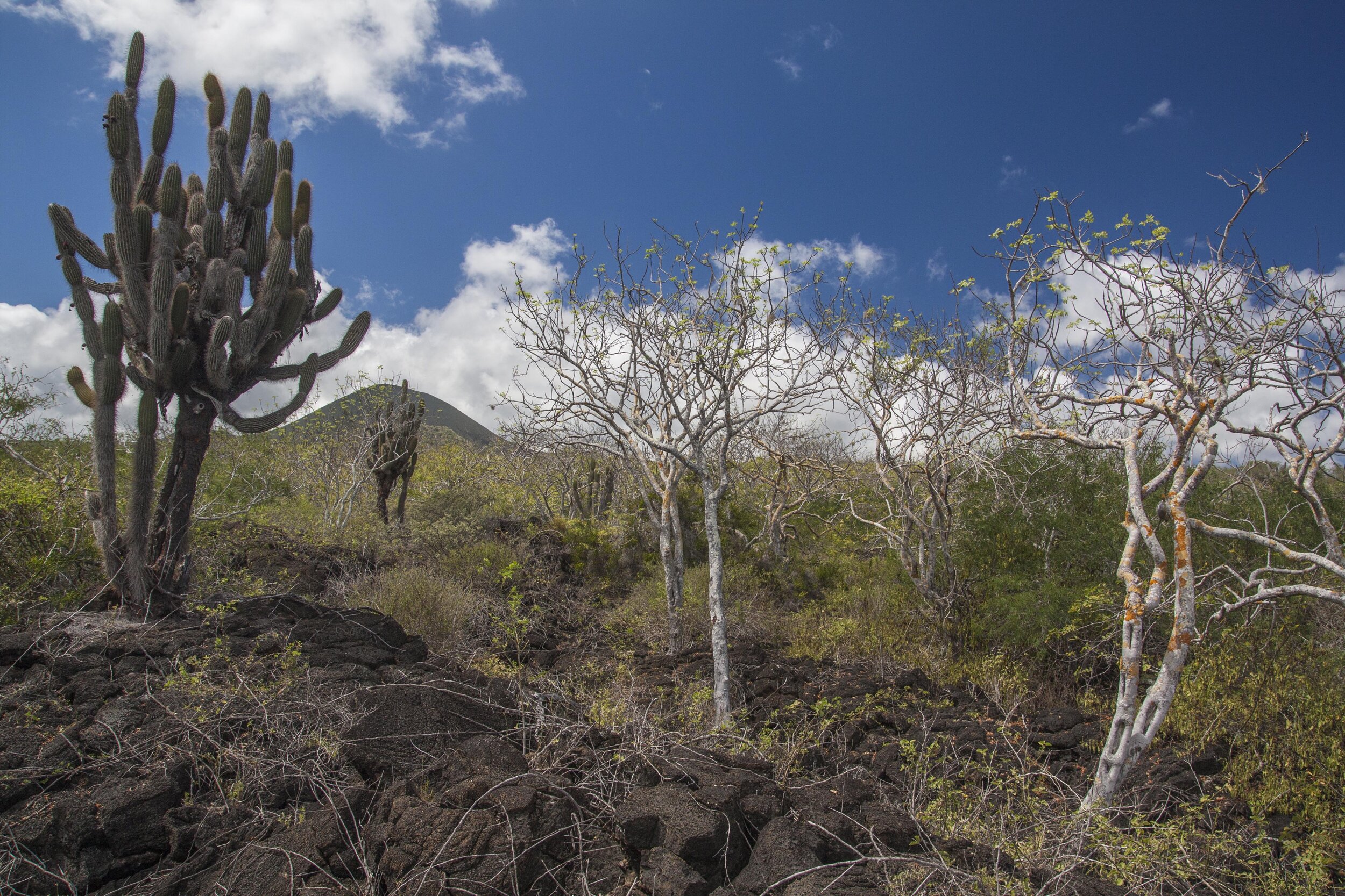
Giant Opuntia cacti and sea lions in the desert of Punta Loberia on Punta Loberia on Floreana Island in the Galapagos.

Giant Opuntia cacti at the tip of Punta Loberia, less than an hour’s walk south of the town (corresponding to #1 in the worldview below).

Columnar Jasminocereus cacti in the desert of Punta Loberia on Floreana Island in the Galapagos.

Columnar Jasminocereus cacti on Punta Loberia, looking back toward the main part of the island (Cerro Pajas is in the center).

Cacti and palo santo in the arid lowlands of Floreana Island in the Galapagos.

Arid zone vegetation, including ghostly, usually leafless palo santo trees.

There are two sites in the highlands that are easily visited from the coastal village of Puerto Velazco Ibarra; each of my two Floreana-inspired worldviews incorporates one of them. The first is Cerro Alieri, a semi-circular hill (half of a volcanic cone) situated right on the edge of the highland zone and reaching 340m. It’s covered by a transitional forest that I wouldn’t call lush, but particularly around the summit it’s packed with colorful bromeliads both on the ground and above.

Hiking trail to Cerro Alieri through the dry forest of Floreana Island in the Galapagos.

Beginning the walk up to Cerro Alieri from the main road.

View of Cerro Pajas from Cerro Alieri and the dry forest of Floreana Island in the Galapagos

Near the summit of the hill, looking back toward Cerro Pajas.

Lush bromeliads on Cerro Alieri on Floreana Island in the Galapagos

The trail runs a few minutes downill past the summit of Cerro Alieri through bromeliad-filled forest.

Lush bromeliads on Cerro Alieri on Floreana Island in the Galapagos

View from the end of the trail on the far side of the summit (corresponding to #10 below).

Floreana below depicts a journey between Punta Loberia, a peninsula on the west coast, and Cerro Alieri. Though I did do the roughly 3-hour walk between them (in pieces), the work focuses mostly on the two endpoints.

Abstracted watercolor painting inspired by Floreana Island in the Galapagos.

Floreana, watercolor on paper, 25”x21”.

 
The sequence of experiences along the “journey” between Punta Loberia and Cerro Alieri that inspired Floreana. The smaller arrows represent views off the main route of travel, near the summit. (#8 represents the summit itself, with views across the …

The sequence of experiences along the “journey” between Punta Loberia and Cerro Alieri that inspired Floreana. The smaller arrows represent views off the main route of travel, near the summit. (#8 represents the summit itself, with views across the eroded crater toward Cerro Pajas, the island’s highest point.)


The second highland site is Asilo de la Paz, location of one of the archipelago’s earliest settlements and now home to a breeding center for giant tortoises (though Floreana’s native tortoise species has long been extinct). The forest here was disappointing in that the Scalesias were mixed with what I assume were non-native trees, given that on Santa Cruz and other islands that elevation is typically characterized by pure Scalesia forest where it’s left. The highlight of the area was in fact a labyrinth-like trail with granite walls, topped with bromeliads.

Granite labyrinth and bromeliads near Asilo de la Paz in the highlands of Floreana Island in the Galapagos.

The granite labyrinth at Asilo de la Paz.

View of Cerro Pajas from Asilo de la Paz in the moist highlands of Floreana Island in the Galapagos.

View of Cerro Pajas from Asilo de la Paz, across highland vegetation (a mix of natives and non-natives).

Abstract watercolor painting inspired by the coast and highlands of Floreana Island in the Galapagos.

The Last Island, watercolor on aquabord, 20”x16”. (The title came from my aim to emphasize the conservation angle of the work for the 2019 SF Open Studios Exhibition.)

The green center of The Last Island, the second Floreana-based worldview, is inspired by this labyrinth and views from the vicinity. I’ve idealized the vegetation into lush, unbroken Scalesia forest, which even in areas that looked intact (visible from the road and in the distance on the slopes of Cerro Pajas) seemed for some reason less luxuriant than on Santa Cruz despite the comparable elevation.

The landscapes in the lower left are again based on Punta Loberia and vicinity. The views in the upper left are from Punta Cormorant on the island’s north coast, site of a flamingo-filled lagoon backed by an iconic triangular hill, which I visited on that family trip in 1994.

Darren

Islands | Santa Cruz, Galápagos

I’m back to work after six weeks gathering inspiration in Chile, Bolivia and Peru! You’ll hear plenty about the trip in this blog after I’ve begun putting it on paper (my Jan. 8 newsletter gave a visual overview). For now, I’ll pick up where I left off in October with representations of islands, specifically “actual” islands surrounded by water. As I described earlier, these can be thought of as only the clearest examples of the “islands” that essentially represent all of the natural world today, in that the pieces we have left are small, isolated, and rare.

Santa Cruz Island, showing the conversion of nearly the entire highland area to agriculture.

Santa Cruz Island, showing the conversion of nearly the entire highland area to agriculture.

Santa Cruz is the second-largest, and most populous, island in the Gálapagos, an archipelago best-known for its animal life but which is no less fascinating for its flora and ecology. From my own perspective its most entrancing characteristic (as you might guess) is its dramatic ecological contrasts, ranging from an arid zone at sea level to—at the highest elevations—an atmospheric, mist-fed “fern-sedge” zone too saturated to support native trees. This entire transition, originally encompassing around six habitat types, is compressed into an surprisingly small elevational range of only about 700m.

Beach, mangrove and opuntia cactus forest at Tortuga Bay on Santa Cruz Island, Galapagos

Mangroves and (in the distance on the right) Opuntia cactus forest at Tortuga Bay, Santa Cruz Island. (These photos are all from a trip in 2018, my second visit to the islands.)

Opuntia cactus forest along the coast at Tortuga Bay, Santa Cruz Island, Galapagos

The arid zone of Santa Cruz near Tortuga Bay, with giant Opuntia cactus.

Cloud forest of Scalesia pedunculata in the wet highlands of Santa Cruz Island, Galapagos

The highland Scalesia zone, with forest of Scalesia pedunculata (in the daisy family).

Fern-sedge zone below Media Luna in the wet highlands of Santa Cruz Island, Galapagos

Lower edge of the fern-sedge zone near the top of the island.

Santa Cruz, reaching 864m, incorporates this entire precipitation gradient, though as throughout the archipelago (especially on the other three populated islands) its native habitats have been heavily altered if not nearly obliterated. The arid zone is the most extensive and (being unsuitable for agriculture) the most intact, but goats and other invasive species have had significant impacts. The mid-elevation Scalesia forests have been nearly all replaced by farmland and exotic trees. And the fern-sedge zone, without native trees to compete with outsiders, has been largely taken over by forests of Cinchona pubescens (the red quinine tree).

Original (left) and current distribution of Scalesia forest, shown in red, on Santa Cruz. (From Mauchamp and Atkinson, “Rapid, recent and irreversible habitat loss: Scalesia forest on the Galapagos Islands,” Galapagos Report 2019-2010.)

Original (left) and current distribution of Scalesia forest, shown in red, on Santa Cruz. (From Mauchamp and Atkinson, “Rapid, recent and irreversible habitat loss: Scalesia forest on the Galapagos Islands,” Galapagos Report 2019-2010.)

Fern-sedge zone taken over by invasive Chinchona trees in the wet highlands of Santa Cruz Island, Galapagos

Stems of dead Cinchona trees in the fern-sedge zone, killed manually through chemical control (apparently effective, but costly).

The two worldviews below are based on visits to relatively intact remnants of these landscapes, arranged (and edited a bit) to create the impression that they still extend across the entire island.

Abstract watercolor painting inspired by the coastline and highlands of Santa Cruz Island in the Galapagos.

Ascent (watercolor on paper, 18”x18”), essentially an idealization of the now heavily-altered southern half of Santa Cruz.

Abstract watercolor painting inspired by the arid and highland zones of Santa Cruz Island in the Galapagos.

Up (watercolor on paper, 20x23”), an idealized “overview” of the entire island.


Because the island’s highland ecosystems only remain as isolated pockets if at all, it’s no longer possible to travel the complete dry-wet transition without passing through cultivated or heavily degraded landscapes. I find that jumping from one habitat to another, without transition, paradoxically waters down the experience of the contrasts between them—they might as well be on different islands. But in the generally intact northern half of the island (all National Park land unlike much of the populated southern half) the main north-south road does at least take in part of the gradient, from the arid zone into the Scalesia zone.

Years ago, before I began creating the worldviews, my obsession was to find a way of seamlessly (through still photography) capturing a precipitation gradient like the one that originally existed on Santa Cruz. I determined that the imagery would probably turn out to be cumbersome to display and not that engaging from an artistic standpoint, but I’d still been looking for an opportunity to get the idea out of my system. Below is the result: panoramics taken at about every 30m of a total 600m elevation gain, along a taxi ride from north to south (ordered from bottom to top along the route shown on the right side).

Photographic transect along a dry-wet gradient on Santa Cruz Island, Galapagos

A photographic transect across the generally intact northern half of Santa Cruz, from the arid zone into the Scalesia zone (traveling from bottom to top, north to south, sea level to highlands).

I think I was correct in expecting the product to be not particularly inspiring, particularly at this tiny scale, plus since the arid zone was relatively green at that time the contrast with the forested highlands doesn’t come across very well. (And, as you can see from the satellite view, the great majority of this half of the island is within the arid and transitional zones, while the southern half had a much greater extent and diversity of wet habitats before they were mostly cleared.) So think of it as an experiment.

On to another, nearby island in the next post!

Darren

Islands | La Gomera

maps.jpg
La Gomera, with points of interest along the north-south journey depicted in Divide. The dashed line roughly traces the wet-dry divide itself.

La Gomera, with points of interest along the north-south journey depicted in Divide. The dashed line roughly traces the wet-dry divide itself.

My last post focused on my impressions of Tenerife, the largest and tallest of the Canary Islands. Here I’ll move on to La Gomera—smaller, lower, and older with much more eroded topography overall. (You might compare Tenerife and La Gomera to the Big Island of Hawaii and Kauai, respectively.) Reaching only about 5000’ La Gomera lacks pine and alpine zones, but its contrasts between wet and dry are in fact even more dramatic than on Tenerife. The upper elevations of the northern half of La Gomera are mostly contained within Garajonay National Park, protecting the world’s largest remaining tract of laurisilva (a unique form of temperate cloud forest), while its southern half, particularly at lower elevations, is mostly semi-desert if not true desert.

So, while the lowlands are generally drier than the uplands throughout, there’s a clear and dramatic division between the northern and southern halves of the island. Hence the title of Divide, which depicts a sequence of experiences traveling across the island from north to south. (Unlike Great Walk, which represents a linear journey along a single defined route in New Zealand, Divide is more haphazard in that it combines travel along several different drives and hikes.)

Abstract watercolor painting inspired by La Gomera in the Canary Islands.

Divide, watercolor on paper, 20”x20”.

la gomera_ID2.jpg

The journey begins in the town of Hermigua (#1 on the annotated version) in an agricultural valley near the north coast with a more-or-less Mediterranean climate. Hiking up into the valley the climate gets wetter and the fields give way to laurisilva, at first scrubby with scattered date palms (#2) and then growing taller and more lush approaching the National Park. In the Park itself (#3-5), it towers in the river valleys but takes on a more windswept character along the ridges.

At the southern edge of the park comes the “divide” itself. Sadly the island’s highest point, Alto de Garajonay (#6), wasn’t also a figurative high point of the experience. In 2012 a fire ravaged the southwest corner of the National Park including the peak itself, leaving only bare trunks, and at the time I was there clouds obscured views of the arid southern half of the island. (I based the painted view on an image from one of the interpretive displays, rather than one of my own photos.) Yet the low stature of the trunks, plus a few small patches of scrubby but intact vegetation, did reveal a change from the much more luxuriant forest just a few meters to the north.

After driving east to escape the fire damage, I dropped below the divide and out from under the clouds, and found another intact patch of what looked like low transitional forest (#7) between the rainforest and semi-desert. It seemed to weirdly evade description—scrubby but not “dry” like a dry forest, yet also not “wet” like the stunted forest found along ridgetops in the National Park. It had been difficult for me to visualize what that transitional zone would look like, and it turned out to be similarly difficult even when I was there. Given the uniqueness of the locale, I think that’s exactly how it should’ve been.

From a point just south of that transitional forest was a view of the Roque de Agando (#8), a famous granite peak surrounded by bits of similar scrubby vegetation, and a glimpse of the drier valley beyond. From there I drove through a progressively more barren landscape to the town of Playa Santiago on the southern coast, from where a short hike led to views of desert gorges and coastline (#9).

Forest with date palms at the lower reaches of the misty cloud forest of Parque Nacional Garajonay on La Gomera, Canary Islands

Lower reaches of the laurisilva with scattered Phoenix canariensis.

Lush laurisilva (temperate cloud forest) with moss and ferns on La Gomera in the Canary Islands

Laurisilva in a stream valley, Garajonay National Park.

Scrubby transitional forest in the vicinity of Alto de Garajonay on La Gomera in the Canary Islands..

Scrubby transitional forest in the vicinity of Alto de Garajonay.

Scrubby transitional forest on La Gomera, Canary Islands

Transitional forest just below the divide.

Desert coastline near Playa Santiago on La Gomera in the Canary Islands.

Desert coastline near Playa Santiago.

The experience of the “divide” itself (the transitional forest) made the strongest impression on me, mostly because the wet-dry transition is so rapid as to make the transitional forest clearly an edge rather than a recognizable ecosystem in itself, creating that empowering feeling of straddling two environments typically many miles apart. It felt as if fire and other impacts had spared those few tiny patches just for me. Still, those patches are isolated, no longer connected to intact habitat on either side. Needless to say I was frustrated that I hadn’t somehow “known” to visit the island before the 2012 fire when such connections, with trail access, did exist in the vicinity of Alto de Garajonay. It underscores the delicacy of these island environments, and it’s thankful that the fire didn’t spread further into the National Park.

Alto de Garajonay, the highest point on the island of La Gomera, Canary Islands, with remnants of cloud forest devastated by a forest fire

Forest burnt in the 2012 fire, with Alto de Garajonay in the background.

And now I disappear to Chile for a month and a half (assuming the country doesn’t spin any more out of control before I leave in a week)—but first, for those of you in the Bay Area, a final reminder for my Open Studio this coming weekend! (Information below, and note that because it’s my birthday the day after, not to mention Halloween, I may up the ante on the goodies….come help me celebrate!)

Darren

POSTCARD.jpg

Islands | Tenerife

View of the island of Tenerife in the Canary Islands, from the summit of the volcanic Pico del Teide

View northeast across Tenerife, Canary Islands, from Pico del Teide.

In my last post I introduced the idea of nature as “island”—the pieces we have left are small, isolated, and rare. For better and worse they’re precious objects that, even if isolation once kept them safe from our impacts, we now “control.” They’re fully within our physical grasp (i.e. their fates are in our hands), but our perceptual grasp as well. The former is dispiriting yet I find the latter empowering; together they make up my “protective impulse” driving the worldviews.

(There is a negative aspect to that perceptual control too, however. The feeling of being dwarfed by nature’s scale and mystery, of being overpowered by it rather than it by us, puts our humanity in perspective and is one of the reasons we “need” a nature that exists apart from us. That feeling has become very difficult to experience today. It doesn’t factor much into the worldviews (though you can find it in the great majority of nature-themed art), but I should make it clear I wouldn’t think twice about giving up that feeling of control for getting those endless tracts of nature back if we could.)

There are many kinds of islands, but for now I’m going to spend some time on oceanic islands and their ecological “sub-islands.” As I’ve mentioned, oceanic islands as a whole tend to be biologically unique given their historical isolation, but often their height also give them a surprising internal diversity of climates and ecosystems. Experiencing the diversity of a continent compressed into a few square miles might be the ultimate example of the empowering feeling I’ve been talking about.

macaronesia-ID2.jpg

I’ll start with the Canary Islands (named for dogs, not birds), where in 2014 I visited the islands of Tenerife, La Gomera and Lanzarote. Located off the southern coast of Morocco, they incorporate seven main islands and make up two provinces of Spain. They’re part of the ecoregion known as Macaronesia (“Islands of the Fortunate”), encompassing the Azores, Madeira, the Canaries, and Cape Verde.

These four volcanic archipelagos share a number of biological characteristics that are unique to the region, most notably a form of temperate rainforest known as laurisilva because it’s dominated by species in the laurel family. This forest type was once widespread in the Mediterranean region but contracted to the Macaronesian islands during an earlier period of drying climate. Today it’s found in upland parts of the higher, wetter islands, in small pockets where agriculture hasn’t replaced it. Toward the southern part of the region, desert or semi-desert is more dominant. The Canaries, located at roughly the latitudinal midpoint of the ecoregion and with the greatest ranges in elevation, feature a mix of both in addition to alpine landscapes.

Canary Island date palms on the La Gomera in a terraced agricultural valley

A number of horticultural staples (especially in California) are Canary Island endemics or natives. Here is the endemic Phoenix canariensis (Canary Island date palm) on the island of La Gomera.

Grove of Canary Island date palms on La Gomera with mist and cliffs beyond

Wild grove of date palms, La Gomera.

Aeoniums in a rocky rainforest area on the island of La Gomera in the Canary Island

Most species of aeonium are endemic to the Canaries, especially rocky areas at wetter elevations.

An ancient dragon tree in the town of Icod de los Vinos on the island of Tenerife, Canary Islands

A famous dragon tree (Dracaena draco) specimen on Tenerife. Native to the Canaries and Morocco, most exist today only in settled areas.

tenerife_ID2.jpg

Tenerife is the largest and tallest of the Canary Islands, containing Spain’s highest peak and the world’s third-largest volcano—12000’ Volcan Teide. The island’s elevational range has also created the archipelago’s most diverse assemblage of ecosystems, including desert along the southern coast, laurisilva on the northern slopes of the volcano and of the northeastern peninsula, forests of Canary Island pine (Pinus canariensis) on the volcano’s southern slopes and upper northern slopes, and alpine desert in the Caldera de las Cañadas at the top of the island. The native vegetation that remains is reasonably well-protected, but much if not most of it has already been lost to agriculture and coastal development, and the laurisilva in particular will be threatened by a newly warming and drying climate.

Euphorbia plants in the volcanic desert landscape of the Malpais de Guimar on Tenerife, Canary Islands

Euphorbia canariensis in the Malpaís de Guïmar, a lava field on the dry south coast.

Lush laurisilva ecosystem (temperate cloud forest) on the Anaga Peninsula of Tenerife in the Canary Islands

Laurisilva on the northeastern peninsula.

Canary Island pines and lava fields on the slopes of Volcan Teide on the island of Tenerife in the Canary Islands

Pinus canariensis and lava field, approaching the Caldera de las Cañadas.

Approaching the summit of volcanic Pico del Teide on the island of Tenerife in the Canary Islands

Just below the summit of Pico del Teide, rising out of the Caldera. A gondola takes you most of the way up from the Caldera floor, but visitor access to the very top is limited.

Panoramic view of the volcanic caldera of Tenerife, Canary Islands, from the summit crater of Volcan Teide

View across the summit crater of Pico del Teide and the Caldera below (the far edge of the Caldera is the chain of mountains in front of the clouds). For scale, you can see a group of geologists working inside the crater, just left of center.

Airplane sunset view of snow-covered Volcan Teide on Tenerife, Canary Islands

Pico del Teide from the plane at sunset. (My visit to the top came before the snow.)

Reveal, completed this past spring, captures my experience of Tenerife’s diverse environments, with a focus on sightlines between the summit and lowlands. I was on the island for about a week with very changeable weather and the high elevations often hidden in clouds; this particular work depicts a “version” of the island when those sightlines were clear (hence the title), providing that world-shrinking experience that I find so moving. Given that the crater of Pico del Teide is relatively tiny—only about 300’ across—that experience included a sense that the entire mass of the island was being “gathered” up into that tiny point. (That feeling would’ve been much weaker had the peak been simply a summit without a crater. I think that’s because the shrinking sense is more empowering with clear evidence of volcanism—the landmass involved isn’t simply an entire island, but one created by forces that are powerful and dangerous rather than empowering. Until the next eruption at least, they feel “tamed.”)

Abstract watercolor painting inspired by Tenerife in the Canary Islands.

Reveal (watercolor on paper, 30”x50”).

The plan is to at some point create another work, maybe entitled Concealed, in which cloud cover instead masks these landscapes from one another. This was more often than not the case during my visit, and the resulting experience was empowering in a different way that I’ll get into after that work comes into being. Mostly likely that’ll be after I manage to make another trip to the islands to fill in some gaps with the photography, and to add another island or two….

Darren

Separate | Small | Singular

Drawing Boundaries

Before moving on from the stream-of-consciousness theorizing of my last few posts as I promised, I think it could use a quick recap. (Skip past the six bullet points if you’ve already had your fill! But it does lead in to what follows.)

  • The concept of nature apart from humanity has more reality in the mind than on the ground, given 1) how thoroughly we’ve transformed the planet, and 2) that arguably we can’t be separate from nature if we came from it in the first place. Taken to their extremes, these would mean respectively that “nothing is natural” and “everything is natural”—functionally the same thing.

  • These two claims are often used to portray pristine nature as having limited value and relevance.

Dense rainforest canopy in Tijuca National Park in Rio de Janeiro, Brazil

Rainforest of Tijuca National Park, Rio de Janeiro. Protected and experienced as a “wilderness” area despite having been re-planted 150 years ago and today facing numerous pressures from the surrounding city.

BUT:

  • The “nothing is natural” claim would require an impossible-to-define point in human history when nature suddenly disappeared.  (When exactly did humans technically start changing the climate?) Naturalness is a matter of degree.

  • And—even if “nothing is natural” and non-human nature is purely a cultural construct, cultural constructs by definition have cultural importance. The importance of the image of nature to our well-being has been widely demonstrated.

  • And—even if the idea weren’t important, the second, “everything is natural” argument can be turned around to show that the idea doesn’t even have to be important:  it’s as “natural” and justifiable as anything else.  

SO:

  • Ultimately it doesn’t really matter whether nature is part of us, we’re part of it, or some degree of either one. We can justify preserving what we perceive as pristine if we decide it’s the right thing to do—for us, for other species, or both. It’s a matter of values, reinforcing innate biophilic tendencies, not of philosophy or fact; even if the facts are clear to everyone (far from the case), the bigger challenge is getting enough of us to agree on what that “right thing” is.

Needless to say I believe that right thing to be some degree of separation, and from here on I’ll use “nature” and “natural” to mean “relatively free from obvious human impacts.” (Still loaded terms, but for those who don’t believe in using them without scare quotes, hopefully less loaded than before.) That separation obviously has a built-in spatial component—it requires clear physical boundaries—and that’s my segue back to the worldviews.

From Edges to Islands

All of the worldviews deal with edges, not just in terms of the fractured representational style but the places they represent. I led into the human-nature relationships discussion with depictions of sharp contrasts between nature and civilization (Hidden Valley, Páramo and Lagoon), and that type of edge is the most directly relevant to that discussion. But edges are tied to the preservation theme even when civilization’s out of the picture. Nowadays, whether or not they’re human-created, they almost certainly define endangered “islands” of nature. Edges imply not only separation but relative smallness and isolation.

Parallel vegetation zones of alpine grassland, rainforest and agricultural landscapes on the slopes of the volcano Mount Taranaki, New Zealand

Edges on the slopes of Mt. Taranaki, New Zealand—nature-meets-agriculture and nature-meets-nature.

Abstract watercolor painting inspired by Rangitoto island and Auckland, New Zealand.

Harbour Island (watercolor on paper, 18”x18”). Inspired by Rangitoto Island, Auckland, New Zealand—a city-nature edge overlaying a natural land-water edge.

The shrinking extent of the earth’s remaining natural areas enters both sides of the human-nature debate: on one hand it compels us to draw boundaries around what’s left, but on the other it’s used to justify the futility of obsessing over those remnants. Though I don’t subscribe to the second perspective, both of them actually correspond somewhat to my two aforementioned motivations for creating the worldviews:

  1. concern over the fragility of natural remnants, and

  2. the empowering sense of control I feel in experiencing a given natural environment from edge to edge, in other words the very smallness and fragility of those remnants.  

I say “somewhat” because #2 doesn’t mean at all that I’m advocating further shrinking of those remnants (or would oppose enlarging them)—quite the contrary—but rather that I experience a small and strange silver lining in the currently precarious state of things. So those motivations may seem contradictory in terms of how I feel about that current state of the environment, but not in terms of what I think we should do about it.  

I think of my “protective impulse” as resolving the contradiction between the desire to preserve nature and the desire to feel a sense of control over it because protectiveness is a form of control. (Similar to the way trying to keep a place untouched by humans is itself a human act.) Yes it’s treating nature like a precious object, more valuable than ever for the very reason that there’s so little of it left, which can distract us from other crucial environmental issues and has troubling social parallels. But I think it gives me a small glimmer of pleasure and hope—as precious objects can do—within a more general feeling of despair.

This could well be just my personal worldview in the wider sense of the term. But I wonder if it could also help inform a larger environmental ethic of concern (if not alarm) tempered by a conviction that the flip side of our domination of the planet is that we do still have some control over its fate (and ours). For a short time at least.

The Nature of Islands

More to come later on how attitudes toward the human-nature relationship relate to ideas about space and scale. For now though, I’ll keep the focus on islands—specifically in the traditional sense of being defined by water. Island nature tends to be rare and endangered not only because of islands’ relative smalless: particularly in the case of distant volcanic islands, eons of isolation have produced high levels of endemism, and topographic relief has created dramatic variety of environments and their associated species within islands (ecological “sub-islands”) as well as between islands and other landmasses.

Lava and cinder cones in the alpine volcanic landscape of Haleakala Crater, Maui, Hawaii

Harsh but delicate volcanic alpine landscape of Haleakala Crater, Maui.

Lush cloud forest relict in the clouds in Haleakala Crater on Maui, Hawaii

Remnant patch of Maui’s little-remaining native cloud forest at the other side of Haleakala Crater.

Both despite and because of geographical isolation, the natural rarity of these species and ecosystems has been magnified many-fold by human pressures: not used to outsiders, island species are particularly susceptible to invaders (human and non-human). And on top of that threat, as on continental mountains, the finely-tuned climatic conditions of islands will be hit particularly hard by global warming.

The worldviews I’ll describe in the next few posts capture the precious yet precarious nature of islands—special and distinct yet no longer protected by expanses of water. Some of the islands are real, but idealized in order to emphasize what’s still left and reflect some of what’s already been lost; others are imaginary but inspired by real places. Here I’m introducing a few of those real-life islands, some that have already inspired worldviews and some that soon will. Enjoy!

Darren

View across the coral lagoon to Mount Gower and Mount Lidgbird, Lord Howe Island, Australia

Low, scrubby lowlands of Lord Howe Island, Australia, with Mt. Gower (far right) in the distance across the lagoon.

Lush mist forest with ferns at the summit of Mount Gower on Lord Howe Island, Australia

Mist forest at the top of Mt. Gower, an ecosystem unique to Lord Howe. Well-protected and mostly intact, but it won’t survive a drying climate.

Arid desert landscape with cacti with lava rock on San Cristobal Island in the Galapagos Islands, Ecuador

Semiarid lowlands of San Cristóbal Island, Galápagos.

Trail through the lush fern-sedge zone in the highlands of San Cristobal Island, Galapagos

Saturated treeless highlands of San Cristóbal. The habitat type is rare to begin with, and the few bits that have escaped cultivation are highly degraded.

Dry, arid landscape with euphorbia on the leeward side of La Gomera in the Canary Islands

Semiarid coastline of La Gomera, Canary Islands.

Lush laurisilva (temperate cloud forest) with ferns and moss on La Gomera in the Canary Islands

Rare and endangered laurisilva (temperate cloud forest) in the La Gomera highlands.

Realities of Nature | "Just" an Idea?

My last post dealt with reasons the image of pristine nature or wilderness, regardless of its basis in reality, is essential to our well-being (and why even determining its “basis in reality” is problematic). Here I’ll wrap up this particular set of foundational ideas, at least for now.

Lush Scalesia cloud forest in the highlands of the island of Santa Cruz in the Galapagos

Cloud forest of Scalesia pedunculata in the highlands of Santa Cruz Island, Galápagos. Only miniscule bits of this habitat remain. If any place on earth deserves to be preserved as a “living museum,” the Galápagos would be it.

Giant Groundsell, Senecio kilimanjari, in the mist on the mountain slopes of Kilimanjaro in Tanzania

Giant groundsels (Senecio kilimanjari) on the slopes of Mt. Kilimanjaro. Rare montane species like this one will be severely threatened by climate change—to what degree is it worth trying to soften the impacts, if it’s possible at all?

As I brought up before, a number of writers and designers see wilderness as having limited value and interest because it’s only an idea. At best it’s boring and simplistic, not worthy of our intellectual or aesthetic attention. At worst it misleads people into thinking that “real” wilderness completely apart from humanity actually exists, moving them to treat it as an exotic “other” to be either defeated and exploited as the enemy (as has generally been the case historically) or idolized as a collection of increasingly small and precious objects at the expense of the much more needy remainder of the planet. It’s true that this concept of the exotic other has unfortunate cultural parallels, driving the double-edged sword of colonization and (think “the noble savage”) glorification. And it’s a valid concern that heavily-impacted environments, like agricultural areas and urban ecosystems, are undervalued or written off. Yet focusing on the heavily-impacted at the expense of the least-impacted is like letting our museums deteriorate while we devote attention to troubled neighborhoods; I doubt anyone would argue with humanity’s entire tradition of venerating objects, or that we can’t value the museum and the neighborhood at the same time. Yes there are very valid arguments over degrees of preservation and the best allocation of resources: we may decide that saving a rainforest from invasive species (let alone a drying climate) isn’t worth the economic cost compared to restoring an artwork or a monument. But, that still reflects a weighing of cultural values. The view that wilderness as a cultural construct isn’t worth valuing or thinking about at all seems to ignore, a bit ridiculously, the fact that a cultural construct by definition has cultural meaning.

Lava and cinder cone, among the many volcanoes in Timanfaya National Park on the volcanic island of Lanzarote in the Canary Islands

Timanfaya National Park on Lanzarote in the Canary Islands. This entire volcanic landscape essentially came into being with eruptions in the early 1700s, and the activity continues to this day. We generally aren’t under the illusion that places we consider “wild” or “untouched” didn’t and won’t always exist as we know them now.

Note that I don’t advocate freezing a natural environment in time, like a painting, against non-human changes and cycles (where it would even be possible). Ecological and geological change is actually used to illustrate the artificiality and superficiality of the wilderness image, and yes that image usually doesn’t include something like hurricane devastation (setting aside for now the issue of climate change’s role in hurricanes). But, though catastrophic change does happen, the contemporary understanding that environments are always in flux (as opposed to older conceptions of stable “climax communities”) doesn’t imply that nature is always unpredictable, never reaching states of equilibrium or exhibiting cyclical patterns. And as with the decaying hut that doesn’t destroy the image of the primeval forest, the idea of wilderness isn’t so fragile as not to survive some degree of physical variability. If a natural fire regime were (re-)introduced into a western national park, and people were educated about its importance to the ecosystem, the environment’s existence wouldn’t lose its value even though it might get fewer visitors. Nature’s dynamism isn’t an earth-shattering idea to anyone who knows that trees sometimes fall and leaves move in the wind, and it doesn’t make nature not worth preserving in its own dynamic state. (Plus again, even without the image, the physical reality matters too. Just because a forest goes through processes of death and regeneration doesn’t mean we’re automatically justified in inserting our own processes, as if the very changeabilty of both nature and culture supported their inseparability. Yet I have seen that argument made.)

Tree fern and other tropical foliage in a light gap in lush cloud forest, Los Cedros Reserve, Ecuador

A light gap, probably caused by a tree fall, in the cloud forest of Reserva Los Cedros in Ecuador. I doubt such changeabillity would threaten most people’s image of a rainforest, if it isn’t already part of that image.

Red and orange hues of Uluru, or Ayers Rock, in the Northern Territory, Australia,during sunset

Uluru in central Australia is sacred to the region’s Aboriginal inhabitants, and any landscape architect would take an interest in that significance (let alone respect it). Why not the same for the Western veneration of “pristine” nature? Because it’s more recent or fickle? The two cultural meanings may not carry equal weight, but the latter shouldn’t be just brushed aside as superficial. (Drawing on Mick Abbott, “Practices of the Wild: A Rewilding of Landscape Architecture,” in LA+ )

Getting back to my assertion that cultural meaning has meaning—in other words, that it should have a say in how we treat the environment—I shouldn’t have to argue that it’s common sense. But since there are those who don’t seem to think it is (or to be more generous, who don’t seem to have given it much thought), I’ll go ahead and do so based on one of their own arguments. If our inseparability from nature is in part based on the fact that nature produced us, then cultural meaning and values—and our ability to make conscious decisions about our future based on them—must themselves (as products of evolution) be “natural.” And that includes how we choose to define or treat nature, even if it’s as a wide and diverse continuum of human impacts, with little basis in physical reality, that incorporates places we view as sufficiently untouched that we try to keep them that way. In other words, if that continuum is in fact mostly in our heads, then the wide and diverse continuum between us and microbes also collapses—everything we are and do is just as natural as they are. Either neither continuum is real, or they both are.

Ultimately it doesn’t really matter. As you can see, the debate over whether or not we’re part of nature becomes tedious, and in fact we don’t really need to resolve it in order to demonstrate that cultural meaning means something. Either culture is part of nature and therefore deciding to protect nature is at least as natural and justifiable as impacting it, or it isn’t part of nature and so we can preserve nature as something separate from us. It’s really all semantics—what does “separate” actually mean?

Hiking trail through lush rainforest in Tijuca National Park, Rio de Janeiro, Brazil

Replanted rainforest in Tijuca National Park, Rio de Janeiro. Despite it’s human history, the park feels as natural as any—and that’s what should matter.

Again, it depends on whether we’re talking about physical reality or mental reality—I won’t rehash all of that mostly because honestly by now I’ve gotten myself a little confused about the whole thing. But, I’ll bring in McKibbin’s view (in The End of Nature) that collapsing the human-nature continuum into an everything-is-natural perspective just seems intuitively wrong. True, no one can argue that we and everything we do and make don’t operate within the same natural rules of physics and chemistry as everything else, but how many of us would actually consider that relevant to our day-to-day lives? Maybe some would (and again I’m egregiously ignoring what many traditional societies believe regarding these issues), but I’d predict that more likely they say it to justify some destructive action rather than feeling it. I think the point here is that denying the value of that mental reality—what “separate” feels like to us—is denying that humanity means anything at all.

In one sense at least, though, I’d agree that we can’t separate ourselves from the rest of the planet: all of “us” now share a common fate. It’s less a philosophical human-nature relationship than a functional one, and Nash (Wilderness and the American Mind) asserts that it’s this realization that has recently convinced us (though not enough of us apparently) to think of nature as something separate, or in fact something that we need to now think of as separate if it and its psychological benefits are to be kept anything close to intact on any meaningful scale. The desire for separation is as functional as the current planetary situation driving it. It doesn’t grow out of a particular belief in the naturalness of that separation due a belief in the naturalness of everything; it’s just what we feel we need to do. In any case, though, we’re just back again to the recognition that all this philosophizing isn’t very useful in guiding our ideas and actions on conservation or preservation: we should do what we decide is best for humanity, and hopefully the people making the decisions are the ones who agree with you (or me) about what that best thing is.

So, I may have just succeeded in showing that most of this and the last two posts just went in a big circle. But I think that turned out to be the point: arguments that humans aren’t somehow special (and that nature isn’t therefore distinct and special too) won’t lead us anywhere useful or good.

I will be doing some more philosophizing later on, but it’ll be more spatially grounded—to the worldviews on paper and to patterns of design and development in the real world. First though, back to imaginary islands for a little while, since I need a break too.

Darren

Giant Opuntia (prickly pear) cacti and walking trail at Tortuga Bay on the island of Santa Cruz in the Galapagos

Another scene from the Galápagos—forest of Opuntia echios var. gigantea at Tortuga Bay, Santa Cruz Island. “Museum-quality”?

Realities of Nature | Continuums of Pristine

Dramatic peaks and rainforest in Tijuca National Park, Rio de Janeiro, Brazil

Parque Nacional da Tijuca with Rio de Janeiro in the distance—the world’s largest replanted tropical rainforest (and largest urban park). I’ll have a lot to say about this park in future posts, as in many ways it gets to the heart of what “natural” and “wild” mean to us today.

This post will go into more depth on the topics I introduced last time dealing with “nature” or “wilderness” as an idea vs. a reality—or more accurately I’d say, different types of realities. I realize that this gets far into the weeds, but more than anything else it’s a way to help me get some foundational ideas (mine and others’) organized and in writing before I move into more spatially-oriented thoughts on human-nature relationships in the worldviews and in real life. Thanks as always for coming along for the ride, and a reminder that comments are welcome!

Also, a note that these ideas reflect a mostly Western, if not American, perspective. Global attitudes toward nature might be converging in some ways, but the reality is complex, and ethnicity and socio-economics certainly factor in as well. While I have some general knowledge of this diversity, currently I’m not in a position to go into any depth. At some point I may, but for now the Western perspective is most relevant to my own experiences out in the world and to creating the worldviews, so it’ll remain my focus.

Is “pristine” nature as a physical reality truly gone? Did it ever exist? Does it matter?

Sand dunes and vegetation in Mo'omomi Preserve on the coast of Molokai, Hawaii, run by the Nature Conservancy

Mo’omomi Preserve (foreground) on Molokai. It’s relatively intact, but with a few exceptions the rest of island’s native vegetation has been replaced by exotics. The Reserve boundary is marked by the fence in the upper right corner; is this place “pristine”? Maybe it depends on which direction you’re looking.

As I introduced in the last post, nature apart from humanity has more reality today as an idea than as a physical state given the degree to which we’ve transformed the planet. My take (not original, but far from universally held) is that this doesn’t make it any less “real,” or any less worthy of attention and at least some degree of protection.

Before I get into the reasons why pristine nature has value as an idea, I’m going to argue that even if it didn’t, in fact it isn’t only “in our heads.” To claim that it’s gone from the physical world isn’t technically in dispute, but only if we use an all-or-nothing concept of “pristine” that could never have any practical meaning as long as humans have existed. By any definition the earth before humans was pristine (if we’d been around to call it such), but after that, where did pristine end and not-pristine begin, in both space and time? What about when the very first humans started breathing and changing the composition of the atmosphere, on a level that was obviously negligible but also not zero? (And which primates do we even count as being the “very first humans”?) What about the Americas, or even the other side of Africa, when those early humans were hunting and gathering? What about Hawaii when it was first discovered by the Polynesians but not settled? The rest of Hawaii when part of it was settled? Mt. Everest right after it was first climbed? After the first hundred people climbed it? After the first discarded oxygen tank, but from a spot where it wasn’t visible? Mt. Everest today?

Tree with buttress roots in primary rainforest on the Caribbean island of Dominica

Me in primary (never cut) rainforest on the island of Dominica. Hurricane Maria probably did significant damage here a few years later; is the likelihood that it was made worse by climate change high enough that “pristine for most practical purposes” no longer applies?

The point is that either all of these places were still pristine (and all places now still are too), none of them were, or there’s a continuum of meaning. Neither of the first two options makes any intuitive sense—there’s little or nothing pristine about Manhattan (unless it’s just all natural; more on that later), and the entire world wasn’t suddenly human-dominated at the dawn of our species. So that leaves the continuum option: there’s no such thing as pristine or not-pristine, only more or less so. Pristine nature today may indeed be a cultural construct—even just by virtue of our delineating it—but to say that construct is never coupled with any degree of physical reality, and therefore deserves no special status, is using a meaningless definition of “pristine.”

Of course climate change sheds a new light on this continuum. I’d argue that it doesn’t change it qualitatively in the physical sense; Bill McKibben in The End of Nature claims that it does, given that until now our impacts always had a boundary of sorts, but I’ve tried to show that the physical reality of that boundary was itself always a matter of degree. (The psychological boundary is a different story, and I’ll get to that below.) But there’s no question that the quantitative change in the definition of pristine will be profound, if it isn’t already in certain places. If a purist definition doesn’t make sense given that it’s impossible to say where it begins and ends in time and space, it’s quickly becoming much easier to say where it ends, and so that purist definition is no longer quite as useless. From a strictly ecological perspective, protecting let alone talking about nature apart from humanity is still a matter of degree, but those degrees are dropping away as they climb on the thermometer.

The psychological continuum

Bumpass Hell, an area of bubbling hot springs with boardwalk in Lassen National Park.

Hot springs area in Lassen National Park. I’d guess that for most visitors, the boardwalk doesn’t destroy the image of nature operating on its own terms.

Lush temperate rainforest with tree ferns along the Milford Track in New Zealand.

Temperate rainforest along the Milford Track in New Zealand. Introduced mammals have had significant ecological effects here and throughout the country, but the untrained eye wouldn’t know it. How meaningful is that knowledge to the experience of the landscape?

Regardless of how we interpret the range of real human impacts on the environment, needless to say they aren’t all perceptually the same. Plenty of altered or even entirely artificial landscapes and ecosystems are considered untouched, either because we think they actually are (like in a remote and mature second-growth forest) or because we want to overlook the knowledge that they aren’t (as might be the case with invasive species). “Pristine” exists on a continuum in our minds just like it does on the ground, but it also incorporates the literal meaning of the word that most of us can envision for certain places. McKibben notes that our image of untouched is “durable”—a boardwalk or an abandoned, decaying hut might not ruin that image (though interestingly a discarded coke bottle might. Maybe this is because the hut symbolizes nature “prevailing” but the bottle is a harbinger of the opposite?)

There are a number of reasons the image itself, whether based on something close to or not so close to physical reality, is worth our consideration. In Wilderness and the American Mind, Roderick Frazier Nash discusses the importance of just knowing something out there exists that’s “not us”—whether or not we’re actually there. E.O. Wilson’s concept of biophilia suggests that our connection to the biological component of that something is innate, evolved, and essential to our well-being. Even more broadly Nash writes that nature perceptually apart from us, as the source of humanity and the “baseline” for evaluating it, gives meaning to civilization as a whole. Just as wilderness has no meaning outside of us (as no “idea” can), civilization would have none without the continuing existence of “pre-civilization.” Nature isn’t just beyond us but also bigger than us. Above all, even though it makes us feel small and precarious, it also gives us consolation to know that we’re not “on our own”—and if this sounds akin to religion, McKibben does make that analogy.

Again, climate change distorts all of this, or at least it will. In terms of nature’s meaning and relation to us, I agree with McKibben’s claim that there’s been a qualitative shift. We could always at least imagine somewhere completely beyond human influence, regardless of how small or how far away, but now we can’t. Since the purist definition of “pristine” does have some psychological reality, that realization doesn’t just knock a few degrees off the continuum—now everything is human, and we are on our own. Only denial in some form (whether it’s “climate change doesn’t exist” or “it does exist but I can’t come to terms with it yet”) is keeping that realization from dawning on all of us; I’m still somewhat guilty of the second type of denial but that’s quickly changing. As that happens, I’m not sure how much and how fast it’ll change my own views on what I consider natural and worth preserving—honestly I prefer not to give it much thought yet. Hopefully the relevance of the ideas I’m exploring here won’t be completely obliterated.

It looks like I’ll need one more post to wrap up this set of background concepts, so stay tuned. After that, I’ll return to the worldviews for a bit before spending some time connecting them to these larger ideas.

Darren

“Fern-sedge” zone in the wet highlands of Santa Cruz Island in the Gálapagos, with invasive quinine (cinchona) trees

The “fern-sedge” zone atop Santa Cruz Island in the Gálapagos—too wet for native trees to have evolved, but not for invasive quinine trees (standing dead in the middle ground, killed by chemical control) that are transforming this landscape into forest. Preventing or reversing such impacts is difficult and expensive, and climate change will make it all but impossible. But, scientific losses aside, how much of a psychological blow would it be if these islands ceased to be special?

Realities of Nature | First Thoughts

Secondary rainforest on the island of Dominica in the Caribbean

Rainforest on the island of Dominica—secondary (previously cut), but most wouldn’t know it without first visiting a primary forest. In fact the secondary forest, with a lusher understory, looks more quintessentially “jungle-like.”

I mentioned in an earlier post that in this blog I won’t stay away from loaded terms like “nature,” “natural” and “wilderness” (for now I’ll use them interchangeably). They’re often considered simplistic and misleading because they suggest something fully apart from humanity, despite the fact that we’re inextricably linked with it physically and psychologically. It’s true that pristine nature is no longer an ecological reality, and that even when it was, our very act of protecting and even defining it as something outside of humanity made it “human” in a sense. But as you’ll see, it isn’t so simple to say (as many do) that the concept of wilderness has no use or meaning—if it’s all in our heads, that’s simply a different kind of reality, and one that fills a crucial psychological role.

In the worldviews I think about and depict nature as special and distinct, which means intact at the small scale (e.g. no invasive species or cut trees) but not necessarily at the larger scale (e.g. when it’s isolated by or juxtaposed with “civilization”). And, by portraying it in the first place, let alone idealizing it in these ways, it’s become something more than just a physical thing out in the world. So while these issues have been on my radar for years, I’ve recently been giving a lot more thought to the question of what “natural” really means to me and to humanity, especially given how quickly the answer is changing given today’s environmental realities.

Abstract watercolor painting inspired by the Heaphy Track in Kahurangi National Park in New Zealand.

New Zealand’s Kahurangi National Park (depicted here in Great Walk) has experienced relatively minimal human impacts over the centuries, notably having avoid a proposed scenic road in the 1970’s. But is it less “natural” now just because we’re deliberately keeping it that way?

This is the first in a series of posts (not necessarily consecutive) that’ll look at this bigger question—they’ll be a little more “academic” than those focusing specifically on the worldviews, but I find that my motivations for the works don’t have much substance without a larger theoretical context. (It’s part of the reason I find the term “artwork” too reductive.) Recently a few people have told me—and I agree—that the future writing projects that this blog is intended to jump-start should take the form of a memoir, which I plan to use as a way to personalize my more academic interests (essentially, what plants and ecosystems mean to us symbolically and the ways those meanings are revealed). So as always, especially those of you in the design/environmental fields who might think about these topics more than most, I’d love to hear your impressions. (And don’t forget that you can leave comments below—these days I’m longing to get into some in-depth discussions that aren’t political arguments on Facebook!)

Sahara sand dunes at Erg Chebbi, Morocco

Erg Chebbi in Morocco. The Sahara was once lush, likely desertified in part by overgrazing. How “wild” does that make it?

Physical vs. Cultural Reality

Tree with large buttress roots in the Amazon rainforest in Tambopata-Candomo Reserve, Peru

The Peruvian Amazon. It’s becoming increasingly clear that traditional land use has had widespread effects on forest structure and composition.

It was while studying ecological anthropology in college that I first realized the range and extent of historical human influence on the planet. Nearly all of it has been impacted to varying degrees by habitation, cultivation, hunting and gathering, fire management, or some combination of those, if not by development and urbanization. Until recently there were certainly places—Antarctica, high mountain peaks, uncolonized/undiscovered islands—where those impacts were absent or negligible, but with the accelerating effects of climate change there’s no part of the earth that can any longer be considered untouched. At least in the sense that humans have been “created” and shaped by nature, and have in turn shaped it from the very beginning, it’s true that we’re just as much a part of it as every other species.

Tents in campground near the summit of Mt. Kilimanjaro, Tanzania

Approaching the summit of Mt. Kilimanjaro. Places like this have stayed essentially free from human impacts until recently, but the glaciers are fast disappearing. How long can the wilderness image survive this (not to mention the hordes of climbers)?

Despite all this, as I first explored in depth in an environmental philosophy class, Western culture has always had some concept of a “pristine,” non-human nature, which over time has alternated between hostile and benevolent, corrupting and redeeming, worthless and precious. This idea of wilderness has persisted even though it’s become less and less of a physical reality, because we’ve been able to convince ourselves that somewhere out there (whether or not we’ll ever see it) that reality still exists.

The fact that climate change is now destroying that reality completely, as Bill McKibben describes in The End of Nature, will have profound implications for wilderness as an idea; how quickly that happens will probably depend on how quickly the effects become widely perceptible. For now I think it’s fair to say that even for those of us who don’t deny that climate change is happening, enough (myself included) are in emotional denial to keep idea of a pristine nature hanging by a thread. Regardless, both because and in spite of the disappearing physical reality of that nature, and the fact that it’s no longer our mortal enemy except when it fights back, the idea has become all the more essential to our psychology—now in the most benevolent, redeeming, and precious sense. Nature may be a cultural reality and not a natural one given that there’s no longer anything truly apart from us, but it’s also a manifestation of that inseparability—nature is now as much a part of us as we’re a part of it.

How Inseparable?

Colorful native vegetation in the bushland of Bluff Knoll, Stirling Range National Park in Western Australia

Bluff Knoll in Stirling Range National Park, Western Australia. It was established to protect one of the last remnants of a global biodiversity hotspot, but given its long history of Aboriginal use plus the current spread of fungal die-back (mostly by shoes) and difficulty of replicating the natural fire regime, it’s far from pristine.

In graduate school for landscape architecture fifteen years ago, these topics all came up again but with a particular and (as I saw it) concerning angle, if not agenda: if humans are inseparable from nature, meaning pristine nature is just a cultural construct, then there’s nothing to stop us from continuing to erase the distinctions that still remain. Back then landscape architectural practitioners and theorists, increasingly in my program at Harvard but also notably at Penn, inspired by environmental writers like William Cronon (“The Trouble with Wilderness; or, Getting Back to the Wrong Nature”), latched on to this attitude to justify a focus on natural process rather than form or image. If nature’s always in flux, the argument went, and cultural processes are part of that flux, our (or the designer’s) job is to encourage natural and cultural processes to work together for the benefit of both.

The spatial mixing and merging that would result from such functional integration was considered not only “natural” but good, “interesting” and “honest.” It would create a non-idealized representation of humans’ “real” place in the environment, unlike somewhere like Yosemite that’s artificially and misleadingly frozen into a static, romanticized image. As for the few places that are truly close to untouched by humanity and everyone agrees we should leave alone: they were seen as out of sight and out of mind, not worthy of our interest in why they’re important to us or why we might like to design things next to them.

I should stress that this viewpoint was particular to a few academic programs focused on being cutting-edge, and probably not shared with equal enthusiasm by everyone within them. Also, in landscape architecture at least it seems to have lost traction (or at least the discussion fell off) around 2013, replaced by concerns related to social justice. But these issues aren’t going away, and given that pristine nature is now truly only in the mind, the view that any sort of physical separation between civilization and perceived wilderness should be created or maintained will likely continue to face opposition. Maybe in some cases it should. But going to grad school after being immersed in deep and nuanced college discussions of these topics, and with more of an interest in the non-human environment than most of my colleagues, I found these arguments for further “merging” over-simplified and even lazy. “Separate” in this context has many meanings and degrees which have changed over time and are changing even faster as we speak. Much more to come on this!

Darren

Luxuriant primary cloud forest at Los Cedros, northwest Ecuador.

Primary (never cut) cloud forest at Los Cedros, northwest Ecuador. It’s pretty close to “pristine,” but given the forest’s reliance on mist and rain, climate change will surely change that. Psychologically, when and how will that start to matter?

Relict Nature | Lagoon

At the risk of frailejone overload (can there be such a thing?), I’m devoting another post to my experience in Ecuador’s El Angel Ecological Reserve. The previous post dealt with one of the two zones of the Reserve that I visited; this one will deal with the second, Voladero Lagoon.

Espeletia pycnophylla, or frailejones, in windswept paramo overlooking Voladero Lagoon in El Angel Preserve in Ecuador.

Frailejones overlooking the lagoon.

Espeletia pycnophylla, or frailejones, at Voldero Lagoon in the paramo of El Angel Ecological Reserve, Ecuador

The lagoon, surrounded by frailejone-studded slopes, is accessed by an hour-long loop hike from the road. Here the plants are taller and more numerous than in the area around Polylepis Lodge, giving the place a particularly otherworldly atmosphere.

In the resulting watercolor Lagoon, I depict this piece of páramo as a true wilderness relict although (as with Polylepis Lodge) it’s situated close to one edge of the Reserve with “civilization” visible only on two sides. For some reason, when I was there I pictured the hills enclosing the lagoon to be surrounded on all sides by cultivation. This could’ve been because that ring of hills prevented distant views beyond the far side of the basin and I could imagine fields on the other side.

Espeletia pycnophylla, or frailejones, in paramo overlooking farmland in El Angel Ecological Preserve in Ecuador.

Páramo meets civilization.

Abstract watercolor painting inspired by farmland, village, and paramo with frailejones at El Angel, Ecuador

Lagoon, watercolor on paper, 36”x36.”

Another factor giving a more “tamed” feel to the landscape, at least on the day that I happened to visit, was the less gloomy weather compared to the first zone. That the sun was often out, and nothing was hidden in clouds, made the landscape seem less foreboding and more accessible. (On paper I take some liberties with this, adding mist in some areas for variety, but still keep most of the views sunny.) Paradoxically though this meteorological softening of the wild-cultivated boundary also sharpens it. The strikingly surreal vegetation, juxtaposed with agricultural fields, seems all the more surprising when not overlaid with the meteorological conditions that maintain its harsh boggy habitat.

Espeletia pycnophylla, or frailejones, in windswept paramo on a sunny day overlooking Voladero Lagoon in El Angel Preserve in Ecuador.
Espeletia pycnophylla, or frailejones, in windswept paramo on a sunny day overlooking Voladero Lagoon in El Angel Reserve in Ecuador.

In other ways too, the fact that aside from the frailejones the overall look of the páramo isn’t dramatically different from the surrounding environment lessens the contrast while also intensifying it. The topography of the Reserve is more rugged than that outside it, but not compared to the rock formations of Hidden Valley. And, away from the tiny areas of remaining polylepis forest and patches of introduced trees between the fields, the contrasting landscapes are both non-forested. So the páramo felt relatively approachable and “knowable” in a way that at the same time made it seem even more wild, surreal and remote. In turn this gave me a greater sense of empowerment, in the way that taming a lion would feel more gratifying than taming a squirrel. (I don’t love this “taming” analogy but it pretty well describes “Motivation #2” for the worldviews—making wild places more comprehensible by isolating and compressing them.)

Darren

Frailejone (Espeletia pycnophylla), member of the sunflower family, in flower, El Angel Ecological Preserve, Ecuador

Frailejone (in the sunflower family) in flower.

Relict Nature | Páramo

Picking up on my last post on remnant natural environments surrounded (perceptually or in reality) by human-dominated landscapes, this one will look at another example—from the páramo of Northern Ecuador, where I spent a few days in June 2018.

Windswept, boggy páramo landscape with Espeletia pycnophylla, or frailejones, in El Angel Ecological Reserve in Ecuador.

Typical páramo landscape with frailejones.

Espeletia pynophylla, or frailejone, with bromeliad (Puya sp.) in the paramo of El Angel Ecological Reserve in Ecuador.

Frailejone with bromeliad to the left. The bromeliads (genus Puya) have bright blue flowers, though I was too late in the season to catch them.

Páramo is a type of alpine moorland—cold, wet and windy—concentrated in the northern Andes above the treeline from Venezuela through Northern Peru. In parts of it the most distinguishing feature are the stands of frailejones (“friar’s ears”), tree-like members of the genus Espeletia reaching 20’ in height. Looking from a distance like giant succulents but in fact members of the sunflower family with spongy stems and soft, fuzzy leaves, these plants give the landscape a surreal and oddly animated look. (I find unbranching “trees” like these with a tuft of leaves at the top to be endearingly human-like, probably part of the reason I’m drawn to them.)

Historically the extent of the páramo ecosystem, and particularly frailejone habitat, was limited given its narrow temperature and precipitation tolerances. But today that habitat has been further reduced, and will be increasingly so, by the spread of agriculture and global warming-induced changes in temperature, rainfall and susceptibility to disease. The area that I visited, El Angel Ecological Reserve, lies between 11,950 and 15,640’ above sea level and is one of the few remaining accessible zones of frailejones in Ecuador (though there are others in Colombia and Venezuela).

Satellite view of El Angel Ecological Reserve, Ecuador
Windswept, boggy páramo and forested streambed with Espeletia pycnophylla, or frailejones, in El Angel Ecological Reserve in Ecuador.

View into the Reserve, overlooking the forested valley.

Lush mossy Polylepis cloudforest along a stream in El Angel Ecological Reserve in Ecuador..

Inside the Polylepis forest.

I was fortunate to visit two parts of the Reserve. The first, in the area of Polylepis Lodge where I spent two nights, includes one of the last relicts of another type of ecosystem, a unique cloud forest dominated by a gnarled, orange-barked tree in the genus Polylepis. This forest filters into stream valleys like the one where the Lodge is situated, just below the páramo.

Despite the Reserve’s relatively small area, the experience of the El Angel from this accessible part at its very edge was more of butting up against civilization (in this case agriculture) rather than being surrounded by it. So the empowering feeling of being in a wilderness relict wasn’t dominant here, but the sense of the páramo rippling endlessly into the distance did reinforce the contrast between its “wildness” and the adjacent fields.

Espeletia pycnophylla, or frailejones, in the paramo of El Angel Ecological Reserve overlooking farmland in Ecuador.

Páramo meets civilization.

The contrast was accentuated also by the mysterious and even mystical atmosphere of the landscape (which has inspired some creepy legends in local folklore), created by the shifting mists and the surreal forms and ghostly white of the vegetation. That the area supposedly also has a real element of danger—the State Department had posted an oddly specific warning about visiting the Reserve due to its proximity to the Colombian border—contributed to the slightly sinister feel, even though literally no one in the country, major tour agencies included, knew what that was about. Back home, putting the experience on paper around Halloween while listening to a “real-life” ghost stories podcast probably had a compounding effect on these impressions.

Windswept, boggy páramo with Espeletia pycnophylla, or frailejones, overlooking valley in El Angel Ecological Reserve in Ecuador.
Misty windswept paramo above forested streambed in El Angel Ecological Reserve in Ecuador.
Espeletia pycnophylla, or frailejones, overlooking forested streambed in the paramo of El Angel Ecological Reserve in Ecuador.

The worldview based on this part of the Reserve (entitled simply Páramo) focuses on the meeting of these wild and domesticated landscapes; I accentuate the contrast by bringing the town of El Angel right up against the Reserve despite its being some distance away by car. I also incorporate the internal contrast between the páramo and cloud forest landscapes.

Abstract watercolor painting inspired by paramo, polylepis forest, village, and farmland at El Angel in Ecuador.

Páramo, watercolor on paper, 32”x40.”

In a later post I’ll talk about the second zone that I visited (Voldero Lagoon) and the worldview it inspired, in addition to more general impressions from the trip. Even though I don’t like to focus on the “tourist” component of these experiences, I’ll end here with some tidbits about my lodging in the Reserve because it was an unexpected highlight. As the name suggests, Polylepis Lodge is nestled into the edge of the cloud forest, in the stream valley at the foot of frailejone-covered hillsides. It’s rustic yet has some touches of luxury and creative design.

Darren

Courtyard with water feature in the paramo of El Angel Preserve in Ecuador.

The Lodge’s rustic “courtyard” with polylepis forest and páramo beyond. It has its own mini-museum of Pre-Polumbian artifacts; that’s one specimen in the center of the pool.

I was the only guest at the time (contributing to the “weirdness” factor), which meant I got a free upgrade to one of the jacuzzi rooms. The brownish stream-fed water took some getting used to.

I was the only guest at the time (contributing to the “weirdness” factor), which meant I got a free upgrade to one of the jacuzzi rooms. The brownish stream-fed water took some getting used to.

The restaurant’s built over a canal that channels a natural stream, hence the partial glass floor.

The restaurant’s built over a canal that channels a natural stream, hence the partial glass floor.

Relict Nature | Hidden Valley

View from rocky summit of Strzelecki Peak on Flinders Island, Tasmania, Australia.

Looking north across cultivated land on Flinders Island from Strzelecki Peak.

In my recent post on Sanctuary, inspired by Strzelecki National Park on Flinders Island, Tasmania, I brought up the tension between two factors motivating my interest in relicts of native ecosystems surrounded by human-dominated landscapes:

  1. These ecological remnants are becoming smaller and rarer due to habitat destruction, invasive species and climate change, driving me to depict and “preserve” them on paper.

  2. On the other hand I also find these isolated pieces of nature exciting, similar to the way I’m generally drawn to environmental edges, contrasts and “islands” (whether encircled by water or by something else). A natural environment is easier for me to comprehend and appreciate when I can experience it in opposition to a contrasting one, creating a feeling of empowerment. In the case of nature surrounded by human-dominated landscapes, that sense of control takes on a “taming” aspect—not very consistent with the conservation angle of #1.

Applying these contradictory reactions to design or conservation in the real world would at the very least require more justification. In fact they tie into a few competing (sometimes heatedly so) contemporary approaches to design and planning, relating to a wider philosophical debate on the relationship between nature and culture—including what “nature” and “natural” actually mean. These are issues that I’ve had an interest in since I was in design school. While the worldviews grow more out of an emotional response to the nature-culture relationship than my intellectual take on it, creating them has led me to dive more deeply into those interests. I’ll be writing a lot more about them in later posts, as one purpose of this blog is to put the worldviews in a wider, more interdisciplinary context. For now I’ll add one more thing—words like “nature” and “wilderness” are highly loaded but I’ll be using them freely, without the scare quotes (even though some of my professors would be shaking their heads). My reasons for doing so go beyond just a lack of better terms. More explanation to come.

Abstract watercolor painting inspired by Hidden Valley, or Mirima, National Park and Kununurra, Australia.

Hidden Valley, watercolor on paper, 24”x18.”

The town of Kununurra with the western half of Hidden Valley National Park (outlined in dark green), and the accessible portion around the actual “hidden valley” (in lighter green) that inspired the worldview.

The town of Kununurra with the western half of Hidden Valley National Park (outlined in dark green), and the accessible portion around the actual “hidden valley” (in lighter green) that inspired the worldview.

Unlike in the real world, in the worldviews themselves I consider the tension between #1 and #2 to be inspirational in itself rather than a potential problem. In real life the natural environment depicted in Hidden Valley is far from encircled by development, but the “insular” feel of the place led me to imagine it simultaneously from both the “conservation” and “control” perspectives.

The work is inspired by the national park of the same name (alternatively called Mirima, in the Aboriginal language) in the far northeast corner of Western Australia,. The park features an “island” of dramatic sandstone formations right adjacent to the town of Kununurra; the accessible part of those formations is cut by a valley that contains the park’s entry road. But as much as the geology, for me what defined the wild character of the park was its baobab trees (Adansonia gregorii), the only species of the genus outside of Africa/Madagascar. There were in fact many baobabs planted in the town itself—an empowering juxtaposition too, if you consider each tree to be its own bit of wilderness “tamed” by sidewalks and parking lots. But despite this intermingling, walking among the baobabs and colorfully banded cliffs in the park I felt much more than a few hundred feet from the city streets.

Hidden Valley is highly idealized in order to accentuate nature/non-nature contrasts. The park is actually bordered by development only on one side and extends far beyond the “hidden valley” itself (the only part of the park interior accessible or visible by road and trail) in every other direction. But, given that the valley zone is the part that I could experience, the park felt like a much smaller, isolated piece of wild nature and I imagined development surrounding it on all sides. So on paper I shrunk the park down to just the valley zone, densified parts of the town, and surrounded the rest of the park with agriculture. Other artistic liberties included borrowing a palm-filled valley from another nearby site with similar geology (Keep River National Park)—I wanted to dial up the internal, natural contrasts a bit too—and adding more baobabs to the valley interior.

The park-town relationship can be experienced in multiple ways. From inside the “hidden valley” itself the town might as well be miles away, and yet because you know it’s there just beyond the wall of rock formations, the contrast is still felt. From observation points atop the rocks overlooking the town, and looking at the rocks from points within the town itself, the park feels a little less wild and isolated but the contrast is right there to see. Hidden Valley incorporates all three of these vantage points. This idea of “revealed vs. concealed” contrasts and the resulting impacts on feelings of insularity and empowerment are more just introduced here than explored, but later works and posts will go deeper.

Baobab (Adansonia gregorii) lit at night with purple light outside a restaurant in Kununurra, Australia.

Night-lit baobab outside a restaurant in Kununurra.

Sandstone landforms in Hidden Valley, or Mirima, National Park in Kununurra, Australia.

Overlooking the “hidden valley.”

One note on the “design” of the town, which is partly real and partly meant to match the part that is. Like most urban/suburban environments, from above and from within, it’s pretty banal (car-oriented, disorganized and scrappy). But I would strive for this effect even if I were designing the town from scratch, which I plan to do in some future worldviews. The reason I’m not inclined to represent avant-garde, master-planned cities alongside wilderness might have something to do with motivation #1 above—I see these constructed environments in a somewhat sinister light, and their being chaotic and lacking clear intentionality of design could reinforce the vulnerability of the relict environments they surround.

View of baobabs on the edge of Hidden Valley, or Mirima, National Park in Kununurra, Australia.

View of the park from the eastern edge of town, with young baobabs (the white sticks) on the slopes.

View of baobabs on the edge of Hidden Valley, or Mirima, National Park in Kununurra, Australia.

Natural relicts tend to have both an ecological and geological component—vegetation as well as landform —so the edge created by agricultural or urbanization coincides to some degree with a topographical edge that would’ve been there anyways, heightening the contrast. (Of course geology usually explains in part why these particular places have been preserved in the first place—rocks, slopes and cliffs will discourage development more readily than plants.) In Hidden Valley both components are significant; in the next post vegetation will play a more important role. Usually landform alone isn’t enough to draw me in, but later on I’ll have a lot to say and show about one important exception—volcanic cones.

Darren

Sandstone landforms in Hidden Valley, or Mirima, National Park in Kununurra, Australia.

Inside the “hidden valley.”

Great Walk | Worldview

This post picks up on the last one, describing my experience hiking the 78-km Heaphy Track, one of New Zealand’s seven “Great Walks.”

Great Walk, the work inspired by the trek, depicts a more purely linear journey than other worldviews to date, the main reason for the long and narrow format. As such it’s brought up considerations that haven’t come up in previous works, like endpoints, relative emphasis/salience of experiences along the way, and direction of “travel” and of the individual perspectives. (The orientation of the perspectives was determined mostly by compositional considerations, but I think whether the viewer is looking “ahead” or “backward” does matter to overall experience of the journey.) This approach is most applicable to places I’ve experienced on a single long hike rather than just wandering around without a single destination in mind. None of the other multi-day hikes I’ve done that don’t form a complete loop (the nearby Milford Track, Iceland’s Laugavegur trek, Mt. Kilimanjaro, the Inca Trail) have ended up on paper yet, but they will.

Abstract watercolor painting inspired by the Nikau palms, coastline, rainforest, and grassland along the Heaphy Track in Kahurangi National Park in New Zealand.

Great Walk, watercolor on paper, 25”x50”.

In sketching out composition options for Great Walk, I discovered that integrating moments covering the entire trek start to finish would result in an overly busy layout. I decided to leave out Day 4, downhill from the highest point of the trek to the finish, which I generally found to be less evocative and distinctive than the rest of the trip. Having already hiked uphill through the rainforest on the windward side of the route, the species were familiar and the overall feel of the forest was less luxuriant, particularly toward the end. Or, maybe I was just exhausted, kept awake all night worrying that my phone would die before the alarm went off at 5am, or I was just ready to return to civilization. In any case, I didn’t take many photos during those last few hours despite the sunniest weather of the trek.

Great Walk with a very rough overlay of the walking route. The numbers on the perspective views correspond to their locations on the satellite view below and the images representative of each experience.

Northeast corner of the South Island of New Zealand with the “painted” portion of the Heaphy Track in red. (The remainder of the trail, mostly the descent on Day 4, is in black.) The numbers correspond to the scenes depicted in Great Walk above and …

Northeast corner of the South Island of New Zealand with the “painted” portion of the Heaphy Track in red. (The remainder of the trail, mostly the descent on Day 4, is in black.) The numbers correspond to the scenes depicted in Great Walk above and in the images below.

Nikau palms in lush rainforest behind the beach on the Heaphy Track in Kahurangi National Park, New Zealand.

1. A dramatic beginning—Nikau palms along the beach.

Dry riverbed in lush rainforest along the Heaphy Track in Kahurangi National Park, New Zealand.

2. Dry Riverbed behind the beach.

Nikau palms in lush rainforest along the Heaphy Track in Kahurangi National Park, New Zealand.

3. Rainforest behind the beach, with nikau palms.

Pedestrian suspension bridge in lush rainforest along the Heaphy Track in Kahurangi National Park, New Zealand.

4. Crossing a larger riverbed near the beginning of the ascent.

Lush rainforest overlooking river valley along the Heaphy Track in Kahurangi National Park, New Zealand.

5. Climbing higher—view of a river valley below.

Lush montane rainforest along the Heaphy Track in Kahurangi National Park, New Zealand.

6. Montane rainforest—no more palms.

Montane forest along the Heaphy Track in Kahurangi National Park, New Zealand.

7. Climbing higher through “drier” forest.

Lush grassland and stream in the Gouland Downs along the Heaphy Track in Kahurangi National Park, New Zealand.

8. Crossing the Gouland Downs.

Lush grassland along stream in the Gouland Downs along the Heaphy Track in Kahurangi National Park, New Zealand.

9. The Gouland Downs.

Lush grassland and stream in the Gouland Downs along the Heaphy Track in Kahurangi National Park, New Zealand.

10. Nearing the edge of the grassland.

Forest and hills along the Heaphy Track in Kahurangi National Park, New Zealand.

11. Entering the forest again.

Forest along the Heaphy Track in Kahurangi National Park, New Zealand.

12. An understated end to the story (but not the walk).

Lush vegetation and view of mountains at the highest point of the Heaphy Track in Kahurangi National Park, New Zealand.

13. View from the highest point of the trek, beginning of Day 4.

The big exception to this relative lack of drama/novelty on the last day was the view, from the exact high point of the trail just as the sun was coming up, of snowy mountains framed by tropical-looking heaths encrusted with ice. But I left that landscape out of the composition too, because I decided that the clearest “ecological narrative” from the uphill part of the trip was moving from the exotic and luxuriant to the familiar and subdued—the progression from “tropical” palm-fringed beaches to grassland and forest that at times looked not just “New Zealand temperate” but “Northern Hemisphere temperate,” seemingly a world away. As I wrote in the last post, this narrative might’ve felt more natural and dramatic in reverse, but in fact I like the subdued way that the journey in Great Walk ends, even if it’s a bit open-ended. Finishing with the sunrise vista would’ve been a return to the drama and novelty of the beach.

Having just written that though, I’m thinking that that alternative idea—bookending the journey with equally dramatic jungly beach and snowy mountain scenes—is also worth trying out. I might also work in an image or two from the downhill portion at the expense of a few from the uphill, but de-emphasized in relation to the mountain scene so that the work still “ends” (literally) on a high note. The descent would be treated as an afterthought, with the mountain view simultaneously representing the elevational climax of the journey announcing the beginning of that descent and what I experienced to be the end of the trip.

Darren

Great Walk | The Heaphy Track, New Zealand

Abstract watercolor painting of palms, rainforest and grassland inspired by the Heaphy Track in Kahurangi National park in New Zealand.

Great Walk, watercolor on paper, 25”x50” (now with a proud new owner, my friend Richard Ervais!).

In fall 2017 I spent about three weeks traveling around the North and South Islands of New Zealand. Four worldviews have come out of that experience—there will be more!—including the recently completed Great Walk, inspired by the Heaphy Track in the northwest corner of the South Island.

The Heaphy Track is one of seven “Great Walks” throughout the country—multi-day treks of exceptional environmental interest maintained to a certain standard including electrified huts. The most famous of these is the Milford Track, which I did also, and you’ll definitely hear about that one too later on. But while the scenery was less dramatic, the Heaphy Track made a greater impression on me in terms of its diversity of species and ecosystems.

New Zealand with the Heaphy Track location in red.

New Zealand with the Heaphy Track location in red.

The Heaphy Track (from the New Zealand Department of Conservation).

The Heaphy Track (from the New Zealand Department of Conservation).

The 4-day “walk” (I love how the Kiwis call them “walks,” as if they’re everyday activities, and in fact they’re much more ingrained in the culture than something comparable in the USA) runs about 50 miles through Kahurangi National Park, taking in subtropical coastline, varied forest types, and high-altitude grasslands. It can be done in either direction; most walk east-west, beginning at the foot of the mountains and ending at the coast, though for logistical reasons I did it in reverse. As I’ll talk more about below, I was reminded that if such environmental journeys are experienced as narratives (which for me they always are), directionality matters as much as it would for a novel or symphony with its structure read or heard backwards.

Beach on a cloudy day with rainforest and nikau palms along the Heaphy Coast, New Zealand

Nikau palms along the coast, a few hours into the trek.

Rainforest with nikau palms behind the beach along the Heaphy Track, New Zealand

Rainforest with nikau palms behind the beach.

Day 1 began in the early afternoon in a light rain (actually much better weather than predicted), on a trail hugging the coastline just a few meters back from a string of beaches. Occasionally the sand is interrupted by rocky outcroppings lifting the trail upward for dramatic views along the coast, or by streams crossed by narrow suspension bridges. (Until a few years ago these stream crossings were done on foot, requiring close attention to weather and tides and resulting in more than a few tragedies.)

The most striking thing about this part of the South Island coast should be obvious from the photographs. Though at a latitude roughly equivalent to that of New York, thanks to a warm ocean current this coastline is home to the world’s southernmost naturally-occuring palm, the nikau (Rhopalostylis sapida), which is the dominant canopy species in the rainforest fringing these beaches. The nikau is noteworthy not just because palms in general are unexpected this far south, but because such a tropical-looking palm is even more surprising. Most of the world’s other hardiest palms—the Mediterranean fan palm, the needle palm, the dwarf palmetto—look decidedly non-tropical, with their shrubby forms and fan-shaped leaves. This is considered subtropical rainforest (or even temperate by some measures), but aside from the pleasant temperatures it feels as tropical as any in the quintessential “South Pacific.”

At the start of Day 2, the trail turned inland and began to climb. The palms became sparser and eventually disappeared, the exotic look of the rainforest sustained by tree ferns and giant heaths (genus Dracophyllum—in the same family as azaleas but looking deceptively like tropical houseplants). It was at this point that I started wishing I had done the walk in the more popular direction. Most people choose to end at the coast, because of the dramatic ocean views that open up on the last day plus the fact that the beach always feels like an appropriate place to end a long hike. For me though, given my obsession with palms, the reason had more to do with wishing I could have experienced the transition from temperate to tropical-like, seeing the palms slowly appear and then overwhelm. It seemed like a more natural progression, maybe because traveling from the more-familiar to the less-familiar is a storyline that tends to leave us with the strongest impressions. Briefly I decided that one day I would come back and do the walk again “properly”—though that conviction faded as I gradually realized the current progression was in fact creating its own unique narrative. More on that later.

Rainforest with nikau palms along the Heaphy Track, New Zealand

Rainforest at a slightly higher elevation as the trail turns inland.

Rata tree and tree fern in lush rainforest along the Heaphy Track, New Zealand

A gigantic southern rata, Metrosideros umbellata, with my hiking poles (bottom center with white handles) for scale.

Giant rata tree with epiphytes in rainforest along the Heaphy Track, New Zealand

Looking up toward the canopy of the tree in the previous image.

Heath (Dracophyllum) in rainforest along the Heaphy Track, New Zealand

Giant heath (Dracophyllum sp.).

As the trail climbed higher and slowly began to level out, the character of forest became coarser, shorter, and “drier” (probably because of a change in soil type rather than precipitation), with decreasing species diversity. The tree ferns disappeared, though the occasional tropical-looking heath still stood out sharply against the tiny leaves of the surrounding foliage.

Rainforest along the Heaphy Track, New Zealand
Rainforest with tree ferns along the Heaphy Track, New Zealand
Forest along the Heaphy Track in New Zealand.

This and previous 3 images—the changing look of the forest as the trail climbs.

Boggy tussock grassland in the Gouland Downs along the Heaphy Track, New Zealand

A boggy area of the Gouland Downs (the white on the trees in the background is a trick of the morning light, not snow).

Early on Day 3, the scrub gave way to a boggy, moody tussock grassland (the sky was mostly overcast with off-and-on rain) known as the Gouland Downs. While the landscape does look alpine in some ways, the absence of trees is due to the poor, wet soil rather than low temperatures—the elevation is only around 800m/2,600’—and in fact the grasslands are surrounded and broken up by forested hills, mountains, and rocky karst zones. Given the overall temperate look of the vegetation, I actually found the place vaguely reminiscent of a field-and-forest matrix in Europe or the Eastern USA, as English settlers apparently did too when they tried and failed to graze sheep there in the 1800’s. In any case the tropical-looking nikau forest felt a whole lot farther away than a day’s walk, a sense of separation amplified by the self-contained feel of the Downs—a special world unto itself. The forested mountains blocked any views or reminders of the more luxuriant environments below.

Tussock grassland in the Gouland Downs along the Heaphy Track, New Zealand

Looking across the Gouland Downs.

Toward the end of the day, the trail left the Downs and passed into the forest again—one very different from any of the previous types. Those were either scrubby or rainforest-y depending on the substrate; the higher-elevation ones certainly felt temperate, but still like Southern Hemisphere forests because of the unfamiliar species. This one felt like a typical forest in the northeastern USA—I think it was some combination of the spindly trees and light, ash-like foliage. It certainly seemed like I had temporarily left New Zealand.

The Enchanted Forest, mossy beech forest in a karst area along the Heaphy Track, New Zealand

The Enchanted Forest—mossy, gnarled beech forest in a karst (limestone) area within the Downs.

Forest along the Heaphy Track in New Zealand.

“Non New Zealand-like” forest on the other side of the Downs.

Day 4 began just before sunrise in a driving wet snowstorm. Reaching the highest point of the trip, first light revealed tropical-looking heaths with a light covering of ice, framing a view of snowy mountains across the valley that I would be following for the remainder of the walk. The weather improved, soon becoming sunny, as I descended again into ferny temperate rainforest. About 4 hours later I began to catch glimpses of an agricultural valley through the trees, the topography leveled out, and the trail exited the forest.

Giant heath at the highest point of the Heaphy Track in New Zealand, with snowy mountains beyond.

Sunrise vista from the highest point of the walk, with giant heaths in the foreground.

Rainforest along the Heaphy Track, New Zealand

Heading downhill and back into the rainforest on the last segment of the hike.

Looking back toward the mountains across rainforest at the end of the Heaphy Track, New Zealand

The end of the trail, looking back toward the mountains.

In the next post I’ll describe how I distilled my experience of the Heaphy Track into Great Walk—stay tuned!

Darren