Tongariro Alpine Crossing

The snowcapped volcano Ngauruhoe with clouds and alpine landscape in Tongariro National Park in New Zealand

Mt. Ngauruhoe is Tongariro’s most iconic volcano and was the stand-in for Mt. Doom in Lord of the Rings. It last erupted in 1975. (The Alpine Crossing winds around the base of the volcano on the opposite side, at a much higher elevation.)

My previous post on San Francisco will be the last one for a while about “urban wilds,” but this one will still deal partly with a human element. Tongariro National Park, in the volcanic central highlands of New Zealand’s North Island, ranges from temperate rainforest to alpine shrubland to barren mountains and lava flows, all mostly surrounded by agricultural land. The full-day Tongariro Alpine Crossing, one of the country’s most popular hikes, passes through the vicinity of recent eruptions (the latest in 2012) and through some of the park’s most dramatic landscapes.

Boardwalk through alpine volcanic landscape along Tongariro Alpine Crossing in New Zealand at sunrise.

Near the start of the Tongariro Alpine Crossing, just after sunrise.

Darren Sears artist selfie at summit of snowcapped volcano Mt. Ngauruhoe along the Tongariro Alpine Crossing in New Zealand.

Reaching the crater rim of Mt. Ngauruhoe (about a one-hour climb, not officially part of the Crossing).

View of the Blue Lake from the summit of the volcano Ngauruhoe along the Tongariro Alpine Crossing in New Zealand.

View of the Blue Lake from the summit of Mt. Ngauruhoe.

The Red Crater along the Tongariro Alpine crossing in New Zealand.

The Red Crater, at the midpoint of the hike.

Surreal landscape and turquoise waters of the volcanic Emerald Lakes along the Tongariro Alpine crossing in New Zealand.

The Emerald Lakes. Without the Ngauruhoe side trip I would’ve beat the crowds, but I was actually a little inspired by the way they created their own jarring human-wild juxtapositionthe pedestrian (literally) in the presence of the surreal. The lakes felt “domesticated” in a way that, as I’ve gone into before, I find empowering despite the negative impacts.

Close-up of surreal turquoise water of the Emerald Lakes along the Tongariro Alpine Crossing in New Zealand.

In places along the edges of the lakes, the water resembles turquoise smoke.

Snowcapped volcano Mt. Ngauruhoe and the Red Crater, volcanoes along the Tongariro Alpine Crossing in New Zealand.

View back toward the Red Crater and, behind it, Mt. Ngauruhoe.

Alpine grassland along the Tongariro Alpine Crossing in New Zealand and distant view of Lake Taupo.

Beginning the descent toward the end of the hike, from alpine grassland below the lava fields down to forest and farmland.

Hiking the Alpine Crossing and driving along much of the park’s perimeter to and from the trail, I was struck by two contradictory impressions. On one hand was the sharp juxtaposition of the temperate, managed landscape of the park’s surroundings with the wild, inhospitable environment (in both the ecological and geological sense) of the interior. I remember in certain places alpine shrubland on one side of the perimeter road and farmland (presumably former forest) on the other side—it’s very possible I’ve played it up in my mind, but it was as if the transition didn’t even require a perceptible change in elevation. On the other hand, while the beginning and end of the trail do afford views of the park’s exterior (reinforcing the impression of contrast), for most of the hike the place felt like another planet—an exotic, self-contained world. In a sense the second impression reinforced the first by contradicting it, in that my memories of the landscape’s otherworldliness heightened the contrast with its more mundane surroundings when latter came into view again. But in any case the work that resulted from my Tongariro visit—Alpine Crossing—was an initial effort to capture the complexity of how I experienced these relationships between interior and exterior. (I have in mind a second, larger work that would explore this even more deeply.)

Abstract watercolor painting of alpine volcanic landscape of Tongariro Alpine Crossing and surrounding agricultural fields, New Zealand.

Alpine Crossing, watercolor on paper, 23”x20.”

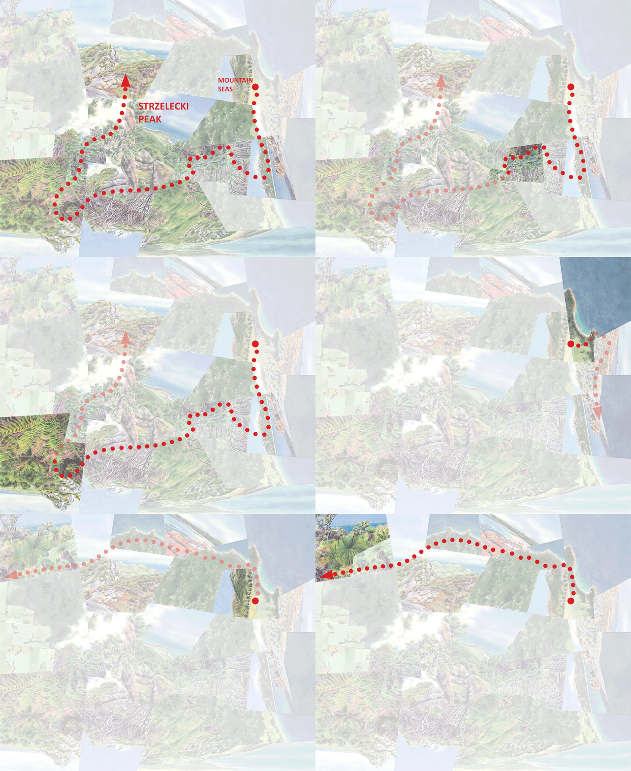
Abstracted route of the day-long Tongariro Alpine Crossing, with each segment described below.

Abstracted route of the day-long Tongariro Alpine Crossing, with each segment described below.

1. Beginning the hike at sunrise in alpine shrubland/grassland that soon gives way to bare gravel and rock.

1. Beginning the hike at sunrise in alpine shrubland/grassland that soon gives way to bare gravel and rock.

2. Continuing through the volcanic landscape, approaching Mt. Ngauruhoe.

2. Continuing through the volcanic landscape, approaching Mt. Ngauruhoe.

3. Reaching the summit and snow-filled crater of Mt. Ngaurauhoe, an hour-long climb off the main trail.

3. Reaching the summit and snow-filled crater of Mt. Ngaurauhoe, an hour-long climb off the main trail.

4. Descending the mountain again and continuing around the other side.

4. Descending the mountain again and continuing around the other side.

5. Overlooking and then weaving between the Emerald Lakes.

5. Overlooking and then weaving between the Emerald Lakes.

6. Passing by the Blue Lake.

6. Passing by the Blue Lake.

7. And finally, re-entering the grassland and overlooking the final descent. The last hour or so of the hike passes through rainforest.

7. And finally, re-entering the grassland and overlooking the final descent. The last hour or so of the hike passes through rainforest.

This work is conceptually most similar to Andes-inspired Lagoon, even though the latter doesn’t depict a volcano, in that both capture otherworldly islands of nature floating in agricultural landscapes. But while in both cases these ecological/geological islands have been drastically downsized in my mind and on paper—the Alpine Crossing in reality traverses only a small corner of Tongariro—Alpine Crossing reflects my perception of having actually crossed this island from one end to the other. It’s one of my earliest works, but it fits in with my recent emphasis on representing discrete journeys across landscape boundaries and transitions rather than what I call wanderings, or less directed and directional impressions.

Darren

Snowcapped volcano Mt. Ngauruhoe in Tongariro National Park in New Zealand with a pink and purple sky at sunrise.

Mt. Ngauruhoe again from the other side, peeking through the clouds at sunrise.

Urban Wilds | San Francisco

To finish up this “Urban Wilds” series as I began it (with a concrete example, in that case Rio de Janeiro), I’ll dive into a recent work, Peaks, inspired by my current home city of San Francisco.

Abstract cartographic watercolor painting inspired by Twin Peaks and the city of San Francisco.

Peaks, watercolor on paper, 42”x37.” The north peaknear the center of the composition, with the upside-down steps—is meant to be the focal point.

This worldview focuses on Twin Peaks—at around 900’ San Francisco’s second-highest point, consisting of two peaks (north and south) that give the place its name. The site is one of the city’s few open spaces that still retains the structure and character of the area’s original landscape—mostly grassland and shrubland particularly in exposed, elevated areas. Most of the city’s other parks have been forested or otherwise completely transformed. Species-wise Twin Peaks has been largely taken over by invasives, but that isn’t obvious to the untrained eye, and restoration efforts are ongoing.

The site’s elevation and its location near the city’s geographical center have made it an iconic landmark and a popular destination. As I’ve suggested in an earlier post its windswept, treeless landscape (in addition to affording 360-degree views) probably has some role in preserving a semblance of coastal California identity that has been otherwise obscured by artificial forests. But I think it has an even greater prominence in my personal experience of the city. First, I live close to the base of the slope—it takes less than 40 minutes to walk to the tops of the peaks. And second, as you’d expect, I gravitate toward it as a relict of a native local ecosystem.

City street in Noe Valley in San Francisco, with Twin Peaks in the distance.

The streets of San Francisco, with Twin Peaks in the distance.

A street in Liberty Hill in San Francisco, with Twin Peaks in the distance.

The site’s prominence is one reason why in Peaks I’ve given it a particularly outsized place in the composition. But that emphasis, as well as my decision to feature it in the first place, of course also has a lot to do with my interest in the dramatic urban-wild contrast. Throughout this “Urban Wilds” series I haven’t said much about what type of landscape the “wild” part refers to except that for me it means an environment in a relatively natural state—not unimpacted by human activity (because there’s no longer such a place) but maintaining enough of the structure and composition of the original ecosystem for it to feel that way. To achieve what I’ve written about as the psychological and cultural benefits of bringing some amount of nature into the city, it doesn’t really matter what that ecosystem is. But to satisfy my own idiosyncratic fascination with the urban-wild contrast, which I explore in many of the worldviews, it does make a difference.

Residential city street with parked cars in San Francisco with Twin Peaks in the distance.

View of the park from the streets climbing the lower slopes.

A street in San Francisco approaching Twin Peaks.

The more unexpected the juxtaposition—the more “wild” the natural half—the more inspiring it is for me. My “Urban Volcanoes” series delves into my favorite example, which I experience as tamed geological power. Another example, ecological in this case, is the saturated, windswept páramo of Andes, juxtaposed with village and agriculture. As ecological examples go, for reasons that are hard to articulate, it’s these high, exposed, damp, and misty places that I find so entrancing when juxtaposed with civilization. (More so than, say, deserts, which are at least as inhospitable. It might be that páramo and other similar environments tend to be topographically isolated and inaccessible, and so I find it particularly exciting when they instead appear right at your doorstep.) But why am I talking about this in reference to a hilltop in the middle of San Francisco, treeless but not particularly high, cold, or wet? I think the answer is that the city’s famous foggy, blustery weather—not as perpetual as many people think, but definitely pronounced in elevated and exposed places—has inspired me to imagine Twin Peaks as more forbidding, exotic, and atmospheric than its physical reality would suggest. That imagined version seems to persist in my mind even when it’s sunny, and so I didn’t feel the need to alter the weather in the worldview (though someday I might create a foggy version).

Street in San Francisco with cars and apartment buildings next to Twin Peaks.

A tiny glimpse of the park between buildings a few streets away.

Street in San Francisco with red apartment building next to Twin Peaks and Sutro Tower.

Reaching the urban-wild edge.

The urban-wild contrast at Twin Peaks is sharp in the sense that generally the urban fabric does suddenly give way to the barren slopes. Even though much of the adjacent development is made up of detached houses, the edge is compressed enough that there’s no petering out into rustic buildings and dirt roads. And, some parts of the boundary are hardened by medium-rise apartment blocks. But on the other hand the shape of the edge is convoluted, with fingers of park and city intermingling, and the two landscapes aren’t topographically distinct—city streets climb far up the base of the landform. Also, though from adjacent streets the peaks do tend to suddenly reveal themselves between buildings or when rounding a corner, from farther away they’re more a fixture of the landscape. So the urban-wild edge here is complex: it separates two distinct environments, but at the same time it represents an interplay between the two that changes as you approach the edge and then cross it. It’s this complexity that I’ve aimed to capture in Peaks, as well as in other works inspired by similar contrasts.

Darren

View of city and downtown of San Francisco from the urban park of Twin Peaks, with windy road.

City vista from below the north peak.

Top of urban park of Twin Peaks in San Francisco with rustic steps.

View of the south peak from the summit of the north peak.

Urban Wilds | Wilds Gradient

In my last post I presented the ecocity vision, conceived by Richard Register, as one model for sharpening the urban-nature separation while embracing a degree of natural “infiltration” into the city that could avoid reinforcing the historically oppositional relationship between “nature” and “civilization.” The concept can be applied to population centers of any size, producing ecocities, ecotowns, and ecovillages. With larger population centers, the idea is that individual neighborhoods within a city could be densified to open up agricultural land and natural habitat in-between, resulting in a sort of archipelago of urban islands forming a larger metro area. Richard’s “Bigger Bay” scheme for the San Francisco Bay Area is an example.

In this post I’ll share some of my own initial thoughts on a possible second, complementary approach to densifying large metro areas while allowing that same infiltration of natural elements. I’ll call it the “wilds gradient” model, illustrated generically in the diagram below. It could incorporate most or all ecocity principles, though it’s more hierarchical than the archipelago approach in that it’s structured by a series of concentric zones ranging from the highest percentage of urbanized space in the center to the lowest at the edges. In that sense it’s superficially similar to the geography of today’s (mostly dysfunctional) cities that typically grade from more dense at the center to less dense at the outskirts. The crucial difference is that the density transition within the wilds gradient is much less granular: it only shows up looking at the city as a whole. All pieces of urban fabric (the white areas in the diagram) in-between the bits of green, if you zoomed in on them, would appear to have nearly the same, very high density, resulting in a much smaller total urban area than today’s typical metropolis (whether or not you include the green parts).

The wilds gradient model shown diagrammatically, with the three concentric zones described below. White areas represent urbanization.

The wilds gradient model shown diagrammatically, with the three concentric zones described below. White areas represent urbanization.

The wilds gradient model divides a metro area into three concentric zones as shown in the diagram above, each named after the shape or character of the “nature” preserved or created within:

  1. Fingers. The natural environment surrounding the city would extend as fingers into the outermost zone of the city, each the size of many city blocks up to that of an entire neighborhood. Their shape and location would be determined by topography, hydrology, or other environmental factors, functional and/or aesthetic. The urban zones in-between (again, just or nearly as dense as the center city) might be considered “ecovillages” similar to the neighborhood islands in the archipelago approach, but they’d be more like urban peninsulas than urban islands. In this zone, the area of undeveloped land would be roughly equal to, or a bit less than, the area of developed land.

  2. Islands. Natural spaces in this zone would still be relatively large (say, several city blocks) and would have a character as natural as the “fingers” in Zone 1, but they would be generally isolated within the urban fabric. These natural islands best fit what I’ve been referring to as urban wilds.

  3. Elements. These natural elements would represent forms rather than spaces—they could be structures like vegetated walls and roofs, or individual plants, in any configuration but importantly part of the urban fabric (or forming a layer overlaid upon it) rather than outside of it. These elements could be situated within “green spaces” like tree planting strips or parks. But these spaces themselves wouldn’t be “natural” in the sense that the configurations of natural elements within wouldn’t re-create a natural environment either aesthetically or functionally. In fact, those configurations could tend toward geometric— clearly of the city—rather than naturalistic.

The configurations of all of these components could and would be much more varied and irregular than shown in the diagrams above. For example, depending on what existing natural features are being preserved (especially waterways), the shapes might tend more toward linear, continuous corridors, varying in width. The second set of diagrams, below, shows how the same zones might look overlaid on a real city, one with a configuration shaped by a real environmental context (in this case a linear system of ridges and valleys).

The wilds gradient model as applied to a hypothetical “real” city, overlaid with the same zones.

The wilds gradient model as applied to a hypothetical “real” city, overlaid with the same zones.

Note that I’m oversimplifying in referring to the entire non-urbanized area (the green area in all the diagrams) as “natural” in the sense of being unmanaged natural ecosystems. The majority of it would be, particularly the green area in-between cities outside the three zones. But the green area would also include some percentage of agricultural land and active recreational space (as in more traditional urban parks).

Fitting the wilds gradient into the “island civilization” approach to planning on a more regional scale.

Fitting the wilds gradient into the “island civilization” approach to planning on a more regional scale.

Zoomed out to the regional scale, cities structured on this transition from fully “wild nature” beyond the city to fully “urbanized nature” in the city center would still appear as compact, isolated urban islands floating in a sea of preserved and restored natural ecosystems, not too different from a pure application of the “island civilization” concept. But zooming in to the city itself, from outer edge to center, that oppositional relationship between nature and city—where nature is seen as something alternately noble and threatening—is softened and inverted. Moving inward from Zones 1 to 3, nature is first intermingled with city, then surrounded by it, then fully “diluted” by it—a reflection and reminder of what our modern relationship with the natural environment has generally looked like. On the level of the entire city this could be considered a “mixing” of urban and natural along the lines of what the Landscape Urbanists propose. But as I said above, this is a matter of scale and perspective: zooming in, the contrast between urban and natural spaces is still enforced. My argument has been that keeping the two spatially separate is crucial from a conservation perspective and perfectly justifiable from a cultural one, but that in order to 1) maintain a sense of ecological identity and 2) to prevent this separation from devolving into the demonization or glorification of one side, we need to think about that condition of separation with more nuance. I think this wilds gradient model could be a way to achieve an environmental version of “separate but equal.”

Like the archipelago approach of fitting large metro areas to ecocity principles of density, compactness and three-dimensionality, the wilds gradient model would take on different forms depending on the particular urban and natural geography in question. Applied to the real world the two models would probably grade into each other, and they could probably even both apply to the same place at the same time at different scales. Regardless of the formal details, though, it’s important to recognize that the overall idea of compressing and densifying cities, while idealistic, can’t just be aspirational. I’ve been focusing on the less tangible benefits of doing so—namely reinforcing the separate yet linked identities of both urban and natural environments—but of course there are much more practical and consequential reasons that are becoming more apparent every day. There are certain to be heated arguments over the degree to which existing population centers can be reconfigured. But there’s no question that the future is going to bring a lot of building and re-building, and we can’t afford to do so the same way that we have been—with low-density sprawl.

Darren

Urban Wilds | Ecocities

Last time I contrasted two approaches to “designing” the human-nature relationship that are, essentially, diametrically opposed. The first is concentrating and/or contracting development into dense urban centers surrounded by nature—Roderick Fraser Nash’s “island civilization” model that I’d brought up earlier, and also embodied to some degree in the New Urbanism movement originating in the 1980’s. The second is dispersing development to create a relatively undifferentiated mix of urban and natural such that both terms essentially lose their meaning—the Landscape Urbanism movement from a decade later—supposedly a more honest representation of contemporary human-nature relationships that in theory inspires us to address environmental issues in a more productive way. I explained why Landscape Urbanism goes too far, but I’ve also talked about why the first approach is also too extreme, or at least an over-simplification—it pushes the natural environment too far beyond our daily experience. For the rest of this “Urban Wilds” series I’ll go into a few ways that the “island civilization” model could be tweaked or enhanced to bring nature (including urban wilds) into cities while maintaining the distinct identities of both.

The complex three-dimensionality of the ecocity vision takes some inspiration from European hill towns, like this one on Italy’s Amalfi Coast. (Photo by me.)

The complex three-dimensionality of the ecocity vision takes some inspiration from European hill towns, like this one on Italy’s Amalfi Coast. (Photo by me.)

The approach I’ll describe in this post is the ecocity vision, developed by artist, writer and theorist Richard Register. The concept has some commonalities with New Urbanism, namely a focus on urban density and walkability, but it also has a number of distinguishing features. One is a focus on “organism-like” complexity and three-dimensionality in urban structure. Obviously a dense, compact city relies on a strong vertical element, but the ecocity goes a step further in its focus on multi-level connectivity through tunnels and elevated walkways. For example a sea of skyscrapers may be the ultimate in vertical design but, as Richard puts it, it’s essentially a two-dimensional city turned on its edge—in a social wellness sense not necessarily an improvement on typical suburban sprawl (we know the fate of many inner-city developments modeled on Le Corbusier’s “towers in a park” concept).

Ecocity concepts, developed by Richard Register, applied to the San Francisco Bay Area. At lower left, densifying the city of Berkeley into distinct ecovillages, with agriculture and natural habitat in-between. At right, a similar approach to the wi…

Ecocity concepts, developed by Richard Register, applied to the San Francisco Bay Area. At lower left, densifying the city of Berkeley into distinct ecovillages, with agriculture and natural habitat in-between. At right, a similar approach to the wider region—withdrawing from zones prone to flooding from rising sea levels—in a poster entry (called “Bigger Bay Ecotropolis”) for the 2009 Rising Tides competition sponsored by the San Francisco Bay Conservation and Development Commission (BCDC). At upper left, an ecocity vision for downtown San Francisco. (Drawings by Richard Register.)

“Keyhole plazas” are an ecocity design feature meant to draw in views of the natural landscape beyond. (Drawing by Richard Register.)

“Keyhole plazas” are an ecocity design feature meant to draw in views of the natural landscape beyond. (Drawing by Richard Register.)

Another feature, particularly relevant to the topic at hand, is the vision’s holistic emphasis on planetary health, giving cities and nature equal and shared value. Unlike Nash’s “island civilization” it obviously thinks of cities as more than a necessary evil or an afterthought, and unlike New Urbanism it treats the natural environment as more than a background or blank slate. This attention to the natural world takes two general forms. First, the environment beyond the city is incorporated into the urban experience though an emphasis on opening and framing views—views that exist in the first place because ecocities (and ecotowns and ecovillages) are sited and shaped in order to preserve and enhance them. And second, natural elements are more literally drawn into the city in the form of day-lit streams, ecological corridors, topographical features, or other spaces that could fit into my “urban wilds” category, plus on a more granular level as plantings of various kinds. Note that “drawing nature into the city” isn’t the same thing as “drawing the city out into nature.” Spatially these two moves may grade into each other, but while “drawing nature in” makes the urban edge a bit softer or more jagged, “drawing the city out” obliterates it (as with the Landscape Urbanism model). The ecocity model is one way to soften the “separate” in “separate but equal” just enough to maintain distinct, mutually beneficial urban and natural identities while avoiding the dangers of pitting one against the other.

Before and after: densifying a downtown and at the same time drawing in (or restoring) natural elements. (Drawings by Richard Register).

Before and after: densifying a downtown and at the same time drawing in (or restoring) natural elements. (Drawings by Richard Register).

A major component of the Galápagos Evolution and Ecocites conference was to be a design workshop for an actual ecovillage in one of two locations in the Islands. Richard developed this concept for one such project on the outskirts of Puerto Baqueriz…

A major component of the Galápagos Evolution and Ecocites conference was to be a design workshop for an actual ecovillage in one of two locations in the Islands. Richard developed this concept for one such project on the outskirts of Puerto Baquerizo Moreno on San Cristóbal Island, with organism-like complexity and three-dimensionality providing ample shade and connectivity. (Drawing by Richard Register.)

I should add that Richard is a friend and collaborator of mine. I mentioned some time ago a project that he and I were working on together—an Evolution and Ecocities conference in the Galápagos Islands focusing on the interrelationships between biological and cultural evolution and ecocity design (particularly in terms of the “organism analogy” I mentioned earlier) in the archipelago and worldwide. The event didn’t end up materializing due to lack of funding, but hopefully the idea will be revisited in some form at some point in the near future. As Richard would emphasize, giving traction to these ideas is no small feat, but it’s becoming more and more critical every day for the future of the planet. (And for the Galápagos in particular, the pressures of development have become a much more serious issue for the Islands than most people realize.) He recently finished a book, The Gálapagos Islands: Evolution’s Lessons for Cities of the Future, covering many of the ideas that were going to be featured in the conference.

Richard is the founder of the International Ecocity Conference series, now having hosted a dozen summits around the world, as well as Berkeley-based Ecocity Builders and a new organization Ecocity World. He has written and illustrated 9 books and given talks in over 30 countries. If you’d like to learn more about the Galápagos project, the ecocity concept or Richard himself, please check out www.ecocityworld.org.

Darren

Urban Wilds | Extremes

First, an update on this fall’s virtual SF Open Studios! I’ll be participating in the Rose Event on Saturday, September 26th from 10am-2pm PDT, one of four live events together featuring 250+ artists. Anyone anywhere can join for free–click here to join/register as a guest (you’ll get email reminders if you register ahead of time). Drop by for some conversation and virtual visits to places that have inspired me.

In the meantime, please check out my new promo video! (You can find it here if nothing happens when you click on the image below.)


In my last few posts I went into two possible benefits of bringing pieces of native ecosystems into cities, softening a little the “island civilization” model of a complete separation between urban “islands” and surrounding nature. The first is strengthening urban “ecological sense of place,” and the second is countering (symbolically at least) the oppositional relationship between city and nature that has led to such disastrous consequences for the latter—if not ultimately for both.  

Here and in the next few posts I’ll move toward describing what an approach that’s similar to “island civilization” in spirit but more nuanced in form might look like. To illustrate the danger of going too far in the opposite direction, but also because parts of deserve consideration, I’ll start by introducing a model from the design world called Landscape Urbanism which proposes essentially the polar opposite of “island civilization.” (Fellow designers might find this discussion a bit dated, since it’s mostly based on recollections from grad school two decades ago filled in by some more recent reading. Please feel free to correct or add anything you’d like to in the comments section of this post on the website—one of my reasons for this blog is to encourage these conversations!)

Honxing Community, Dalian, China, 2009, by Sasaki. A number of Landscape Urbanist tropes are visible here; even in cases where they’re more convincing than this, they need to be weighed against the costs of urban expansion. The arrangement of the bu…

Honxing Community, Dalian, China, 2009, by Sasaki. A number of Landscape Urbanist tropes are visible here; even in cases where they’re more convincing than this, they need to be weighed against the costs of urban expansion. The arrangement of the buildings is inspired by ecological forms of the valley site, though in the ultimate example of aesthetics over ecological function, that ecology has been built over. The green roofs and interstitial ground plantings, even if they looked anything like the original vegetation, would obviously be no replacement for it. (Andrés Duany, “An Album of Images,” in Landscape Urbanism and its Discontents. Original image source: Sasaki & Associates, Intersection & Convergence.)

Landscape Urbanism, originating in the 1990’s, advocates for upgrading rather than halting or reversing the current trend of spatially blending nature and city (i.e. sprawl), as a way of both acknowledging and reinforcing the fact that our activities can’t be separated from natural processes, physically or conceptually. Being dishonest about this reality of inseparability, it claims, is actually detrimental to environmental health. Putting nature and civilization on opposing sides creates either outright hostility toward the environment or objectification and idolization of small parts of it that we consider “pure.” The latter results in neglect of other parts that are less intact or pleasing despite their still having ecological value. (And idolization itself can have its own harmful effects, as in “loving to death” our national parks.) In theory, spatially mixing the two extremes leads to a heightened, inescapable awareness of how we and our environment depend on each other for a healthy existence.

So rather than restoring ecological—and human—health through urban densification, Landscape Urbanism proposes that environmental patterns and processes act as the structuring element for a generally horizontal, dispersed “urban” landscape such that either everything or nothing is urban depending on how you look at it. In projects and proposals following this model, urban infrastructure is everywhere, but so is “nature”—from stream and wildlife corridors down to greenery on seemingly every built surface, with a focus on native species and “ecologies.” (The pluralizing makes me roll my eyes; in fact it’s a tame example of Landscape Urbanists’ often ridiculously impenetrable writing style—check out the now-famous Landscape Urbanism Bullshit Generator—which along with fancy graphics has been accused of compensating for lazy science. )

Plan of Charleston, SC. On the left, the compact, high-density city as it is, analogous to “island civilization” (in this case, nearly a literal island). On the right, a re-thinking of the city along Landscape Urbanist lines, with natural elements (…

Plan of Charleston, SC. On the left, the compact, high-density city as it is, analogous to “island civilization” (in this case, nearly a literal island). On the right, a re-thinking of the city along Landscape Urbanist lines, with natural elements (waterways in this case) rather than streets as structuring elements. The latter is one-quarter as dense, with the other three-quarters forced to go somewhere else—say, to a nearby undisturbed wetland. Charleston wouldn’t be Charleston in the right-hand version, and those strips of coastal habitat would also be better off preserved in that other wetland than mixed with streets and buildings. On the other hand—no, it wouldn’t be Charleston, but it could be some other community that you know and find inspiring. Its environmental deficiencies are real, but it would go to far to say it has no value from a human, experiential standpoint. In designing new cities, it isn’t necessarily either-or. (Duany, “An Album of Images,” in Discontents. Original image source: Duany Plater-Zyberk.)

There are plenty of issues with this “blending” approach, stemming from what’s essentially an erasing of boundaries between humans and nature in the spatial sense but also between the needs of both. It seems to assume that merging the extremes of city and nature into various forms of garden (with native plantings in configurations that are difficult and expensive to maintain, and often too small or superficial to have much ecological function) will keep everyone and everything happy at the same time. This downplays the social and cultural benefits of dense, walkable, human-scaled urban fabric on one hand and the environmental benefits of extensive, unbroken natural habitat on the other. And those downplayed benefits are in fact mutual—dense cities mean less habitat fragmentation, as well as lower carbon emissions that are good for everyone and everything.

I also have problems with the more symbolic justification for erasing boundaries. As my earlier “Realities of Nature” series of posts concludes, our current condition of inseparability from the natural world (whether or not you believe it’s always been our condition) need not be a self-fulfilling prophecy—in fact that inseparability can be the very justification we need for choosing physical separation. And treating parts of the natural world as precious objects isn’t qualitatively much different than, say, preserving archaeological artifacts; we just need to make decisions about what’s feasible and worthwhile using the resources we have.

But I do think certain elements of Landscape Urbanism’s landscape-based approach can have a positive influence on more architecture-focused planning—such as The New Urbanism, considered LU’s competitor, which advocates for traditional dense cities organized around spaces framed by buildings and tends to see natural elements as less relevant in shaping design. (The sometimes-heated debate—see Landscape Urbanism and its Discontents, eds. Andrés Duany and Emily Talen—between the two movements seems to have fizzled early this decade, apparently because it came to be seen as largely theoretical and beside the point given that neither model is mutually exclusive and different contexts call for different approaches.) I don’t think there’s much of an argument that using locally-distinctive natural elements to shape the character of a city and to make nature a larger part of people’s day-to-day experience isn’t a worthy goal—even when those elements are primarily aesthetic, or “visual biophilia” as Duany calls it in Discontents. As I’ve said before, even if it’s hard to quantify, I’d say it’s undeniable that such visuals have an important effect on the urban experience. Biophilia is a real thing, and by definition it’s largely or entirely visual.

The Highline in New York City—one of the best-known examples of Landscape Urbanist-inspired design. It’s limited in scope, more purely landscape architecture than urban design, like the majority of such projects that have gotten built, but it’s shap…

The Highline in New York City—one of the best-known examples of Landscape Urbanist-inspired design. It’s limited in scope, more purely landscape architecture than urban design, like the majority of such projects that have gotten built, but it’s shaped urban character through a decidedly landscape-based move. There have been the unsurprising issues with maintenance and installation—vegetation has been planted rather than “colonizing” on its own as planned—but the project illustrates how an urban space conceived as much as an ecological showcase as a recreational space can be successful (not to mention profitable from a real-estate perspective). (High Line, New York by Mike Peel licensed under CC BY-SA 4.0.)

But bringing natural elements into urban areas—creating “biophilic cites” as Timothy Beatley calls it in his book of that title—needn’t and shouldn’t mean that city and nature lose their individual identities. Landscape Urbanism aims to correct what it considers the fundamental problem with “island civilization”- like approaches to design—a paradoxical devaluing of the environment as the result of over-valuing it as an exotic “other” that we try to preserve but then forget about. But taking the opposite approach ultimately leads to the same problem of devaluation: nature can’t be valued as nature if it’s become indistinguishable from everything else. (You might say that in so strongly giving identity to cities, it gives up its own.) And whether we view nature as “everywhere” or “elsewhere,” we lose sight of the fact that its continued survival relies on our restraint. The solution is treating nature as something in-between, or as multiple things at once. More thoughts on this to come!

Darren

Urban Wilds | Sacred and Profane

Before I get back to the topic at hand—for those of you who might’ve missed my Newsletter sent out on Aug. 11th, take a 12-minute escape from the chaos of the world and check out my latest project, an original composition for 2 pianos evoking the ascent of a fictional, endangered tropical island from sea to summit. It accompanies a sequence of snapshots cropped from my various worldviews depicting idealized and imagined islands and mountains. (I can tell that not many people clicked on it :-D.)

This blog is intended to be more about places than about me, and that’s true for this project as well. But I think it’s fair to say that more than anything else I’ve created so far, this video shows what I’m really about.

(Start with your volume way up and be patient—it begins very minimally at 0:26 and slowly builds. If you’re on my mailing list, go to the Aug. 11th Newsletter for more background on the music itself.)

Now, returning to the subject of urban wilds….

In my last post I wrote about identity, specifically an “ecological sense of place,” as one benefit of preserving islands of natural habitat in urban areas. This time I’ll lead into another potential benefit that’s even more abstract in that I doubt it would be possible to measure or isolate: such islands can act as a reminder that no matter how successful we end up being at pulling back from our current trajectory of destroying the planet, we’ll always be in control of its fate (at least as long as that fate doesn’t include our own destruction).

Though a broad generalization, it’s fair to say that throughout human history (especially in the West) civilization and the natural world have been trapped in an oscillating oppositional relationship, with one viewed “sacred” and the other “profane.” (Michael Dennis and Alistair McIntosh expand on this idea in “Landscape and the City,” Landscape Urbanism and its Discontents.) Cities were first glorified as tiny islands of virtue and security in a sea of mystery and hostility, but later came to be seen as zones of moral decay as urban life began deteriorating and technology began to render nature less threatening. Today, remnants of both these attitudes seem to coexist and compete. Power through growth and technology has produced in many minds a perception of human invincibility, translating into a feeling of superiority over a natural world seen as not necessarily hostile but still something to be subdued, with little to offer us. For others, that strength has created the sense that we’re destroying ourselves and taking nature down with us, an attitude driving us to place extraordinary value (arguably not always justified) on the pieces of it that we’ve spared. In both of these cases nature is seen as something “other,” to be either conquered or idolized depending on how much we fear it relative to ourselves.

View of New York City skyscrapers across a lake from the Ramble in Central Park

New York City skyscrapers viewed from Central Park. Frederick Law Olmsted designed the park as an antidote to the ills of urban life.

Path through forest and boulders in the Ramble in Central Park in New York City.

The Ramble in Central Park, a “wild” landscape intended to impart what were seen as some of nature’s beneficial qualities: complexity and intrigue. It’s largely artificial, having been planted from scratch with largely non-native species, but has transplanting what would’ve been experienced as “wild nature” into the city had any effect on how the urban-nature relationship is viewed? More thoughts on that later.

Roderick Fraser Nash’s “island civilization” concept (Wilderness in the American Mind) essentially proposes that we level the playing field, viewing neither side as the aggressor or the victim. This “separate but equal” relationship—islands of urbanization and cultivation surrounded by preserved and restored ecosystems—would give meaning and context to both nature and humanity. For humanity, it would preserve a “baseline” reminding us of our origins, against which we can measure our progress and to which we can return for inspiration and rejuvenation.

Yet we know how “separate but equal” tends to work out, at least when dealing specifically with people (and it’s not irrelevant that our alternating views of nature as sacred and profane have often included its “exotic” and “uncivilized” inhabitants, encapsulated by the idea of the “noble savage”). Fully realized, the “island civilization” model would restore the world to a spatial condition that originally led to, or at least reinforced, the development of that oppositional relationship. How might that spatial model be modified to embody a more productive relationship between nature and civilization while still keeping them spatially distinct? More to come on that soon.

Darren

Puerto Ayora, the largest population center in the Galápagos lslands. For the most part the town is compact and its boundary sharp (at least on the east side; the western half is a failed, partially-built lower-density development that should never …

Puerto Ayora, the largest population center in the Galápagos lslands. For the most part the town is compact and its boundary sharp (at least on the east side; the western half is a failed, partially-built lower-density development that should never have been approved).

City street in Puerto Ayora on Santa Cruz Island in the Galapagos, with Opuntia cactus trees.

Civilization meets nature at the edge of Puerto Ayora. The sharp edge feels like a dramatic threshold, underscoring the fact that you’re about to enter something different and special. Those adjectives are truly understatements in the case of the Galápagos environment—if there’s any place where the “island civilization” concept should be strictly applied, it’s here. But these islands haven’t avoided the image of an unequal “other,” whether that means inferior to us or superior; both attitudes exist and have brought their own problems. While something as straightforward and tangible as the form of the urban perimeter can’t be held responsible for reinforcing these attitudes, let alone generating them, there is value in thinking about how it might symbolize a more cooperative relationship. And if not here, than for larger urban areas in other places.

Urban Wilds | Identity

My last post on Parque Nacional da Tijuca, Rio de Janeiro’s urban rainforest, alluded to some of the social and psychological benefits of “urban wilds,” defined here as islands of native ecosystems in cities. In that case the city didn’t really have an option other than to restore and preserve the forest, given the importance of the watershed and the impracticality of urban expansion into the Massif (and presumably it was assumed that native plants would result in the healthiest forest possible). But in places where the direct practical benefits of preservation are less clear-cut, what is the actual value of carving out these relatively small islands of nature at the expense of preserving much larger tracts beyond urbanized areas? The wellness benefits of generic green spaces—from parks and gardens down to planted medians—are common-sense and have been well-documented. But to what extent should they at least partially exhibit the region’s ecology as it was before urbanization, anything from forest down to desert, though they might be considered less useful or ornamental?

Parque Nacional da Tijuca again, rising dramatically from the center of Rio.

Parque Nacional da Tijuca again, rising dramatically from the center of Rio.

As I explained in my Realities of Nature posts (long and involved, but here’s a summary), if we start from a common understanding that human and environmental health are inextricably linked, can be objectively measured, and are good things to begin with, then we can agree that sharpening the edges between nature and civilization by contracting our physical ecological footprint, creating a “divided canvas” as Roderick Fraser Nash calls it in Wilderness and the American Mind, is justifiable in an ideal world. That would mean, most importantly, densifying our cities into a series of well-defined urban islands surrounded by preserved and restored ecosystems. While we’re still far from that common understanding, and it’s arguable how achievable that ideal world is, among well-informed people with their values in the right place I don’t think it’s reasonably debatable as a goal.

If “island civilization,” as Nash calls this idea of boundaries around cities rather than boundaries around nature, is taken to its extreme, then technically it precludes preserving or restoring natural areas surrounded by urban development. In terms of direct environmental benefits, it’s generally true that a small piece of native nature has more value beyond the city—less exposed to human impacts, contiguous with much more extensive areas of habitat, and permitting increased urban density with lower auto emissions—than isolated within it. I think, though, that Nash would agree that this extreme version of separation would never be desirable let alone realized, at least for large metropolises. As Tijuca illustrates, most urban wilds exist partly if not mainly for practical reasons, but they may also have benefits that are less tangible—for city dwellers but also (indirectly) for the environment in terms of increased awareness and appreciation. The next few posts will look at these more abstract benefits of intermingling city and surrounding nature to some degree through the preservation or restoration of urban wilds—relatively small and accessible—versus a stricter separation between the two that concentrates all natural areas into much larger and more continuous tracts further afield.

I’ve said a lot about the feeling of empowerment that attracts me to edges and islands, particularly pronounced in the case of urban wilds. That’ll become relevant to the discussion a bit later on. But since I’ve never assumed that many others share that impression (though I’m always waiting to learn otherwise) let alone that it would ever drive planning or conservation policy, here I’ll focus on impressions that are likely much more widespread. These ideas will be speculative and broad-brush, given not only the intangibility of the benefits themselves but the fact that defining what is “inside” vs. “outside” the city, and what is “native,” can be complicated. In the latter case, “nativeness” depends on how large of an area, and on what time scale, we’re talking about. But even on an abstract level these thoughts can provide a framework for thinking about what the urban-nature divide actually means.

Rustic steps and shrubland on Twin Peaks, an urban park in San Francisco.

Twin Peaks, an iconic landform near the geographical center of San Francisco. The ecosystem is threatened by invasive species and foot traffic, but it represents a relatively intact remnant of native California grassland and shrubland.

The first benefit I’ll go into relates to “bioregional identity” or “ecological sense of place”—emotional connection to a certain region based on its native species and ecology. (I’m focusing on the “bio” here because I think talking about the “geo” is less illuminating and less useful—I doubt the positive influences of urban mountain scenery would come as a surprise, and in any case eliminating it isn’t usually an option. It would be interesting to determine how much of Tijuca’s iconic status has to do with its rainforest versus its topography.) There’s been a lot said and written about the concept of bioregionalism and especially the importance of regional and local identity more generally: our physical environments are important in creating a sense of belonging, and that sense of belonging is important to our well-being. The concept of biophilia, explained and popularized by E.O. Wilson’s book of the same name, isn’t explicitly about identity, but its claim that we have an innate, evolved connection to other living things would suggest that other species do have some role in creating a shared sense of place.

View of Twin Peaks from the city streets of San Francisco.

As the city’s second-highest point, visible from many neighborhoods, how important is the landscape of Twin Peaks to the city’s identity?

View of Buena Vista Park from city streets of San Francisco.

Buena Vista Park is another of San Francisco’s hilltop open spaces. Unlike Twin Peaks, and the majority of the city’s parkland not used for active recreation, it’s been converted to forest. It’s cooler, less windy, and arguably more interesting, but what has it lost as a result? Throughout the city there are controversial plans to return pieces of parkland back to their original open landscapes.

But so far I haven’t come across anything attempting to quantify how strong, prevalent or important that biological sense of place is, particularly with respect to cities. A few years ago I had some correspondence on this topic with U. of Illinois professor Frances Kuo, who studies the psychological and health benefits of urban greenery; she said that “everyone more or less prefers the landscapes in which they grew up, and savanna,” but that “I don’t know if that entails a preference for native plants, so much as for familiar plants.” She also noted that “preference is not necessarily the same thing as psychological benefits. So, for example, people may not like walking in an arboretum in the dead of winter, but they still derive psychological benefits from it, according to measures of cognitive function. So, while we have plenty of research on which landscapes people like, we can’t confidently predict psychological benefits from that research, and unfortunately, at this point we haven’t really conducted research on which landscapes people benefit most from.”

So apparently it’s a tough subject to study, and I would add that trying to distinguish a preference for familiar vs. native plants would probably be complicated by the likelihood that many of us without botanical interests or expertise assume that familiar plants are native. And, again, does “native” refer to just that particular urban region or to a wider area that might encompass multiple ecological conditions? And does it include species that have been there for centuries but were brought by humans? Results would vary a great deal depending on whom you ask, and how you ask the question. And it’s probably even more difficult to determine which concrete conservation measures accrue directly from these attitudes.

But I think it’s reasonable to assume that at least for some of us, and to some extent, an urban ecological sense of place is (or could be) real and important—we’d prefer that our natural surroundings, even specifically urban, not be homogeneous. It would be nice if we had some evidence beyond the anecdotal.

Darren

Urban Wilds | Rio de Janeiro

My latest “Urban Volcanoes” series of posts looked at islands of nature in cities through a mainly geological/topographical lens (with the exception of Rangitoto Island, which also has ecological significance). The next few will take a more ecological angle on natural relics in urban areas, though topography often has a lot to do with why they’ve been preserved.

In this post I’ll share an article, “The Other Urban Jungle,” that I wrote for the July/September 2018 issue of My Liveable City magazine. It’s an abridged and updated version of a much more in-depth case study I did on Parque Nacional da Tijuca in Rio de Janeiro, both the world’s largest urban park and largest replanted tropical rainforest, for the Large Parks: New Perspectives conference and exhibition at Harvard’s Graduate School of Design in 2003. You probably already know about this park through images of its most iconic attraction—the Christ the Redeemer (Cristo Redentor) statue.

My study of Tijuca grew out of a primarily design and academic interest in city-nature juxtapositions rather than an artistic one, and I haven’t yet created a worldview based it. But the park is highly relevant to my current pursuits not only because the contrast between dense metropolis and critical conservation area is so stark, in a way that’s significant from both cultural and environmental perspectives, but because its importance is so strongly tied in to the question of what “nature” and “wilderness” actually mean today (see my Realities of Nature posts for a lot more on that topic!).

Below is the full text of the article, along with some of my photography and a few archival images from a thee-week research trip to Rio in 2002.

Darren

Illustrative drawing of Parque National da Tijuca in Rio de Janeiro.

The four sectors of Parque Nacional da Tijuca (my drawing superimposed on Google Earth).

View of Rio de Janeiro, urban forest and dramatic granite peaks from stone steps approaching Tijuca Peak in urban rainforest park.

View from near the summit of Pico da Tijuca, the park’s highest point.

Parque Nacional da Tijuca, sprawling over 3,953 mountainous hectares in the heart of Rio de Janeiro, contains arguably the largest urban forest and the largest replanted tropical forest in the world. Formally declared in 1961, the park is a unique and fascinating synthesis of culture and nature. Not only are playgrounds, ornamental sculptures and fountains, and picnic areas backed by rock faces rising five hundred feet above one of the world’s most endangered ecosystems; the forest itself is a human creation that, when set against the teeming metropolis encroaching on its boundaries, could not appear more “natural.” But Tijuca is noteworthy not only as an island of native forest in an increasingly dense and challenging urban setting; the well-being of the city itself has always been intimately associated with the fortunes of the environment that the park now struggles to preserve.

Tijuca rises from 80 to 1,021m in two ranges running parallel to the coast and together referred to as the Tijuca Massif—a dramatic landscape of isolated peaks, deep valleys, and vertical rock faces punctuated by numerous caves and waterfalls. The park’s four sectors of forest are relics of a rainforest that once extended from the Uruguayan border to the northeastern tip of Brazil. Known as the Mata Atlântica, this ecoregion is older and more diverse than its Amazonian counterpart and has been nearly eliminated due to its location in the most densely populated part of the country. 

Building ruin in urban rainforest of Parque National da Tijuca in Rio de Janeiro.

Remnants of infrastructure from Tijuca’s coffee-growing era.

By 1840, most of Tijuca’s original rainforest, with trees reaching heights of 45m and diameters of more than 2m, had been cleared for coffee cultivation. Yet the Massif represented a valuable resource for the city not only because its cooler, wetter climate provided ideal growing conditions: its streams represented Rio’s only source of fresh water. With diminishing forest cover the watercourses began to vanish during the dry season and flood during the wet, and between 1824 and 1844 a series of droughts had made the situation critical enough to endanger the city’s growth. In 1861, a radical governmental decree called for the restoration of the watershed. The slopes were to be reforested with indigenous trees—a degree of farsightedness that is surprising and refreshing to discover existed at that time, given that a monoculture of fast-growing exotics would have provided more immediate results and would have been more efficient to plant. By 1871, 60,000 trees had been planted, with a survival rate of about 80%. In 1877, an unofficial decision was made to transform the Tijuca Forest, the most level and formerly most devastated sector, into a public park—an escape from the heat and congestion below incorporating plazas, roads, trails, bridges, fountains, and ponds in the style of Paris’ Bois du Boulogne. Also included, for the first time, were numerous exotic and ornamental plants in the vicinity of these features.

Photograph and archival drawing of Cascatinha Taunay in urban rainforest of Parque Nacional da Tijuca, Rio de Janeiro.

Cascatinha Taunay, one of the park’s main attractions, now and in the early 1800’s. (Engraving: Johann Moritz Rugendas, Cascatinha da Tijuca, 1822.)

Urban rainforest paths in current and archival photographs of Parque National da Tijuca, Rio de Janeiro.

Forest paths (not the same path, but in the same general area)—now, and in the late 1800’s soon after replanting. (Left photograph: Marc Ferrez, Pico do Papagaio, c. 1880?.)

Stone picnic table and giant granite boulders in urban rainforest of Parque Nacional da Tijuca, Rio de Janeiro.

Public amenities are well-integrated into Tijuca’s dramatic landscape.

Ornamental garden with waterfall and lush tropical foliage in urban rainforest of Parque Nacional da Tijuca, Rio de Janeiro.

One of the park’s small ornamental gardens (this one built around part of the original hydrological infrastructure).

View of Cristo Redentor on a peak from formal walkway and hedges in the urban rainforest of Parque Nacional da Tijuca, Rio de Janeiro.

View of Cristo Redentor in the distance from another ornamental area of the park.

Tree canopy in lush restored urban rainforest of Parque Nacional da Tijuca in Rio de Janeiro.

Since the park’s creation, the forest itself has generally been left in a state of natural regeneration and is today overwhelmingly the dominant experience of the park, with designed spaces and structures covering less than 5% of its area. The replanted zones form a nearly continuous canopy and have regained a diversity and luxuriance that amazes many visitors (and even scientists) familiar with the site’s tumultuous history. Despite compositional and structural differences from the original forest cover, the present-day forest has been found to contain over 1500 species of mostly native plants, about 400 of which are considered rare or endangered. In 1990, the park was recognized by the United Nations as part of Brazil’s Atlantic Forest Biosphere Preserve. 

As the city has expanded and densified, civilization is once again exerting serious pressures on the park as an ecological system, including pollution, human-caused forest fires, illegal plant extraction, invasive species, and the overall strain of about 1.5 million annual visitors. Even more dramatic is the proliferation of shantytowns, or favelas, as rural poor and displaced urban residents have migrated to occupy Rio’s last affordable enclaves—erosion-prone ridges and slopes. Today there are close to fifty favelas situated on the perimeter of the Tijuca Massif, home to one-third of the city’s total favelado population. The resulting deforestation threatens not only the forest itself: every rainy season, the Massif unleashes several football stadiums’ full of silt and boulders onto the city below, often with significant losses of life and property.

Shantytown or favela on slopes of urban rainforest of Parque Nacional da Tijuca in Rio de Janeiro.

A favela climbing the slopes of the Tijuca Massif.

The relationship between Tijuca and Rio de Janeiro merits special attention because of more than its complex history. It is likely that the encroachment of the city has, in tandem with the re-establishment of the forest, in fact conferred upon the park an even greater physical and psychological importance to the city’s residents. Today, passing within minutes from Rio’s dense neighborhoods and slums into the Massif’s luxuriantly green (and noticeably cooler) landscape, it is clear that the original importance of the park as a retreat from the city has not diminished. Even from miles away, Tijuca’s lush and evocative terrain seems to breathe life into this metropolis of over twelve million people, boasting more trees per person than any other city despite an overall scarcity of open spaces. The Massif’s ruggedly picturesque profile is visible from nearly every point and often dominates the urban landscape, contributing to Rio’s identity as one of the world’s most beautiful cities. Such natural beauty even compensates in part for the city’s harsh social realities, and raises quality of life to an extent that could attract forms of economic development—namely, clean and technology-oriented industries—with the capacity to improve the very social and environmental conditions that threaten a peaceful coexistence between park and city. Rio thus provides a particularly dramatic example of a city where growth and prosperity can be driven rather than impeded by protection of its ecological assets, protection that is potentially self-reinforcing in that its social and economic benefits may in turn facilitate stewardship of those very assets. 

View of Sugarloaf and Rio de Janeiro from the replanted urban rainforest of Tijuca National Park.
Religious offering with fruit and candle on rocky ledge in urban rainforest of Tijuca National Park, Rio de Janeiro.

Religious offering, technically prohibited but unofficially tolerated in deference to Tijuca’s multi-faceted cultural significance.

Outdoor massage tables along road through urban rainforest of Tijuca National Park, Rio de Janeiro.

Massages right along the main park road.

Dramatic cliff face below Tijuca Peak in the urban rainforest of Tijuca National Park in Rio de Janeiro.

Looking up at Pico da Tijuca from the city streets.

Tijuca, today managed jointly by the Chico Mendes Institute for Biodiversity Conservation (part of the Ministry of Environment) and the municipal government, is perhaps unique among urban parks in that the maintenance of its public image as both a pleasant and “natural” alternative to the city is mainly accomplished through the park’s embracing of the natural reconstitution and maturation of the forest, rather than more typical park maintenance practices. Ornamental garden areas are comparatively tiny, and there is no aesthetic “enhancement” of the forest itself. Despite the 2008 Management Plan’s comprehensive detailing of conservation, research, and educational needs and goals, however, resources are not adequate to support significant efforts to adequately combat ongoing threats to forest health and cover that are once more, within a century, expected to reach levels disastrous for the surrounding city.

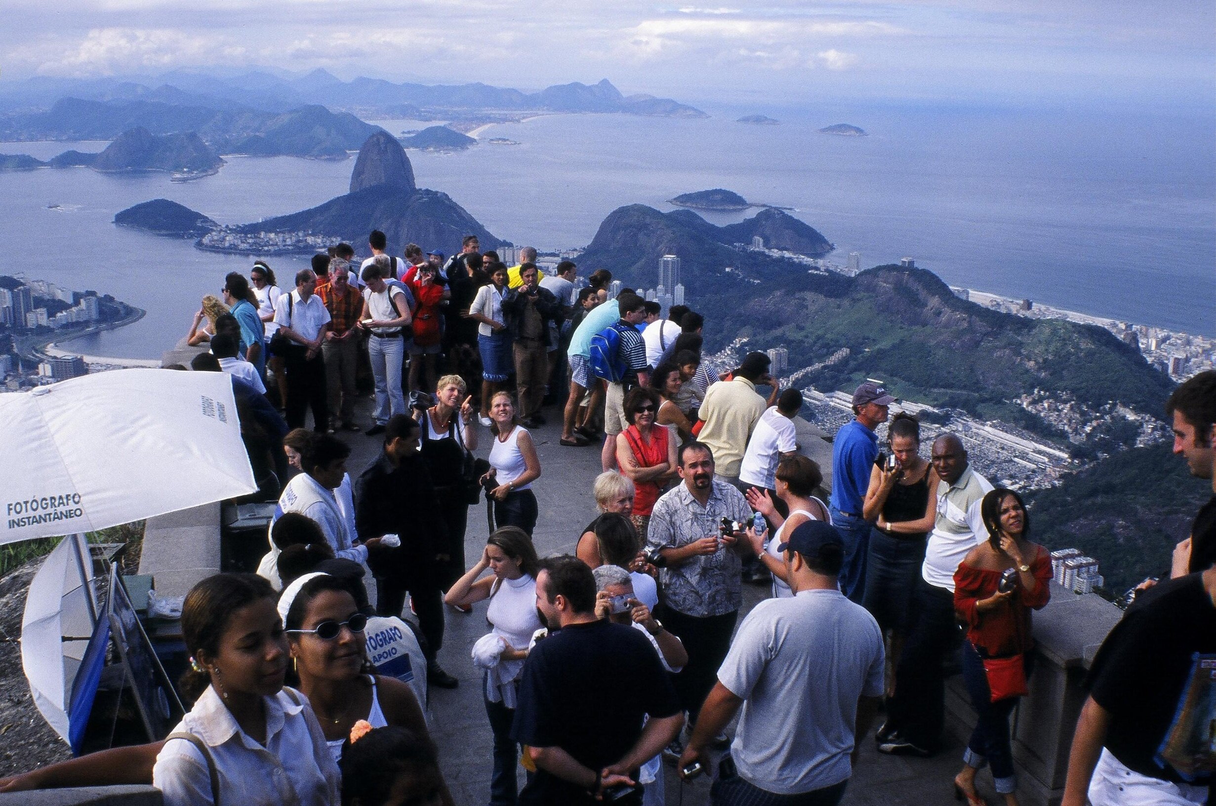
Crowd of visitors at statue of Cristo Redentor in Tijuca National Park in Rio de Janeiro.

Visitors at the Cristo Redentor.

Likely no other urban park in the world has had, over its history, a more diverse set of impacts and meanings than Parque Nacional da Tijuca. But despite past and present challenges, the contemporary visitor’s immediate impression of its landscape is not one of historical upheaval nor of current threats to its integrity. Rather, the unexpectedly lush and mature forest, on weekends teeming with generally respectful visitors truly relishing their surroundings, provides evidence that the perception of “wilderness” can still have a physical and psychological place in contemporary society, even (and especially) within an urban jungle of the more usual kind.  

Green mountains and replanted tropical rainforest in Tijuca National Park in Rio de Janeiro.

Urban Volcanoes | Dreamworlds

Sometime during my 2017 travels around Iceland I had a dream about a cluster of volcanic cones and craters in an urban park. It was after my visit to Vestmannaeyjar (see my previous post) so was likely influenced by the volcanoes there, but these imaginary ones were closely hemmed in by city streets and set among manicured lawns.

Watercolor painting with contour lines on laser-etched plexiglass overlay, depicting surreal dream-inspired landscape of volcanoes and craters in volcanic urban park.

Community Crater Cluster, watercolor on paper and oil pen on plexiglass, 15”x20.”

Community Crater Cluster, one of the works I began during my Iceland artist residency in the period when I’d started working in watercolor but not yet in the fractured style, grew out of that dream. I had to extrapolate a great deal and solidify what had been only very vague impressions—my geography-themed dreams can be really thorough but in this one I remember standing in only one spot, in the lower left corner of the park looking up toward the summit of the cone with the path crossing over it. The larger, “half volcano” at the far right is the only piece I borrowed directly from reality, specifically Vestmannaeyar, rather than some combination of the dream and later imagination. The baseball diamond, though, replaced what’s actually a golf course, being a better fit for the radial form of the crater.

Bicycle path through volcanic crater on the island of Heimaey in Vestmannaeyjar, Iceland.

Entering the “half volcano” on Vestmannaeyjar.

This work was the basis for a newer one, Community Crater Cluster II, which intersperses landscape views with bird’s-eye fragments as in all my recent worldviews. Except for the volcano taken from Vestmannaeyjar, obviously I didn’t have any of my own photography to work from, but luckily I could overlay my mental images on some photos of my hilly San Francisco neighborhood to set up somewhat realistic perspectives. (Though given that it’s all based on a dream, I still allowed myself some liberties there.) The central fragment, with the wrought-iron fence and the long stairway up to the crater, represents the view I remember from the dream—from what might’ve been a cemetery at the base of the volcano. The overall composition, made up of fragments that are more triangular than I typically use, was inspired by the volcanic cones as well as the concept of “view cones” (representing the direction and extent of views from particular vantage points on a map.)

Abstract cartographic watercolor painting depicting surreal dream-inspired landscape of volcanoes and craters in volcanic urban park.

Community Crater Cluster II, watercolor on paper, 36”x45.”

Village Volcano is another work, on a similar urban park theme, that was inspired by a dream—this one a few weeks before leaving on the Iceland trip when I must’ve already had volcanoes in my head. I did a lot more exploration in this dream, to the extent that I had a nearly complete park designed in my mind when I went to put in on paper (also during the residency). In contrast to the first dream, in this case I remember the single crater being hard to find, surrounded by relatively gentle slopes (nearly flat on the left side) rather than situated at the top of a cone, and competing in prominence with a dry, rocky canyon that must’ve been more influenced by California scenery. And, not only is the crater juxtaposed with urban elements, like sports fields, as in other examples I’ve talked about; there’s even architecture built right into the crater walls, as mundane as a food court/shopping center if I remembered it right. So the urban-wild interface in this case is accentuated less by a striking overall contrast between urban and volcanic landscapes than by the element of surprise created by intermingled elements of both.

Watercolor painting with contour lines on laser-etched plexiglass overlay, depicting surreal dream-inspired landscape of volcanic urban park.

Village Volcano, watercolor on paper and oil pen on plexiglass, 15”x20.”

As with Community Crater Cluster my plan is to re-interpret Village Volcano in the fractured style. But I’m thinking that, for the first time since leaving the plexiglass overlays behind, I might experiment with incorporating the topographical lines (with pen directly on paper). Given the gentle slopes, it would otherwise be too hard to read the radial form of the volcano. Stay tuned!

Darren

Urban Volcanoes | Vestmannaeyjar

A few weeks before my July 2017 artist residency in Laugarvatn, Iceland, I spent a few days on the offshore island of Heimaey in the mini-archipelago of Vestmannaeyjar (also known as the Westmann Islands) southeast of Reykjavik and a short ferry ride from the mainland. Vestmannaeyjar is one of the country’s many active volcanic zones; it includes the island of Surtsey, formed only in 1963, and on Heimaey the volcanoes Eldfell and Helgafell which have inspired two recent worldviews. (Incidentally the double “l” in Icelandic is usually pronounced “tl.”)

Village and red volcanic cones of Eldfell and Helgafell on the island of Heimaey in Vestmannaeyjar in Iceland.

Eldfell (left) and Helgafell in the background, looming over the village.

Craggy volcanic topography of the island of Heimaey in Vestmannaeyjar, seen from the Ring Road in Iceland.

Jagged profile of Heimaey in the distance, seen from the Ring Road near the southern coast of the mainland. (The island has a lot of dramatic topography aside from the volcanoes.)

Reddish volcanic cone of Eldfell, seen from adjacent volcano of Helgafell, on the island of Heimaey in Vestmannaeyjar in Iceland.

Eldfell seen from the summit of Helgafell. Located on the outskirts of a village rather than a major city, these volcanoes are less strictly “urban” than those in Auckland, but they don’t feel at all remote.

I rarely buy souvenirs anymore, but I was tempted by these volcano hats….

I rarely buy souvenirs anymore, but I was tempted by these volcano hats….

Heimaey is the largest and only inhabited island in the archipelago, with a population of about 4,000. On January 23, 1973, the volcanic vent that was to soon to become Eldfell (“Fire Hill”) without warning began erupting fountains of lava in a resident’s backyard. The entire population of the island was safely evacuated and the lava flows were slowed by water hoses, but a large portion of the village was buried in lava and ash, and at the end of the five-month eruption about a square mile (a quarter of the island’s area at the time) of new land had been added. Today, the majority of Heimaey’s population has returned, and Eldfell is a dark 200m-high cinder cone looming over the village.

For reasons I went into in my last post on volcanoes in the city of Auckland, small volcanic cones in human settings fascinate me; I was particularly drawn to the tension between Eldfell’s “domesticated” quality (its accessibility plus its backyard origins) and such recent evidence of its destructive power. Home Island below, named for the English translation of Heimaey (there’s something inspiring about the island’s population returning home to a place now so strongly defined by an active volcano), captures this strange and slightly ominous juxtaposition of volcano and village. The work includes one small fragment, near the center, recalling the eruption itself—the first instance that I’ve played with fracturing time in addition to space.

Abstract cartographic watercolor painting on aquabord of the active volcano Eldfell on the Island of Heimaey in Vestmannaeyjar, Iceland.

Home Island, watercolor on aquabord, 24”x36,” inspired by Eldfell.

Abstract cartographic watercolor painting on aquabord of the volcano Helgafell on the Island of Heimaey in Vestmannaeyjar, Iceland.

Sacred Hill, watercolor on aquabord, 30”x22,” inspired by Helgafell. The triangle of brown in the lower left is the summit of Eldfell.

Heimaey’s second volcano, Helgafell (“Sacred Hill”), is located a short walk away from Eldfell and rises to about the same height. It formed about 5000 years ago and is dormant, but its juxtaposition with the village is still striking—seen from town its profile is more perfectly conical than Eldfell, the top few meters are still bare gravel and boulders, and the trail to the summit begins randomly between a farmhouse and a soccer field. The sensation of the island spiraling around the volcano in the worldview wasn’t planned, and in real life Eldfell is much more the center of attention because of its newness to the scene. But I found Helgafell at last equally alluring, probably because it’s been pushed into the background by its more famous neighbor and yet could one day erupt again.

Darren

Urban Volcanoes | Auckland Volcanic Field

My last series of posts focused on how islands are particularly good subjects for the worldviews because their smallness, boundedness, and isolation make them easy-to-grasp, empowering microcosms of the wider world. The islands I described are all surrounded by water, but islands in the less literal sense—surrounded and defined by any type of contrasting environment—can have the same effect, and I can’t think of any place I’ve depicted that doesn’t involve some form of island.

This next set of posts will go back to a topic I’ve dealt with before, another type of island—“wild” places surrounded by “civilization.” Without re-hashing my rabbit hole of a discussion on what I mean by those terms (my Realities of Nature posts), I think anyone would agree that the “inhuman-ness” of natural environments often goes beyond simply lacking a human presence to having a mysterious, sinister or even subtly hostile quality. In my Páramo post I make specific reference to it, but any time I depict or talk about surreal plants or landscapes there’s probably an element of threat that helps to set that place apart. That many of us are attracted to such places relates to the concept of the sublime—a library’s worth of landscape and art historical theory that I won’t get into, but basically it’s the idea that we find it invigorating to be in the presence of danger that can’t actually harm us.

Standing on the edge of the Grand Canyon (behind a guardrail) or below Half Dome would be an example of a sublime experience. But also part of this aesthetic tradition, as it’s been applied to landscape architecture, is the shrinking and encircling of landscapes otherwise truly threatening in their boundlessness in order to reduce that hostility to something more superficial and poetic. (Think the Ramble in Central Park—a zone of unmaintained, unrestrained forested hills and cliffs surrounded by a more manicured, urban landscape. It carries wilderness associations for sure, but the only real dangers are of the urban kind.) I think my own impulse to shrink and encircle nature in two dimensions could be interpreted along the same lines.

Volcanoes are probably the best examples of threatening natural features or phenomena that many find fascinating both because of and in spite of their destructive power. It’s the miniature ones that I’m most drawn to, whether in real life or ones that I’ve imagined, because while that power is still evidenced by the volcanic form, it feels “tamed” or “humanized.” And I find this humanization to be strongest and most empowering when surrounded by human-dominated landscapes, especially urban.

Auckland, New Zealand. Many of the scattered green patches are remnants of volcanic cones, now mostly public parks.

Auckland, New Zealand. Many of the scattered green patches are remnants of volcanic cones, now mostly public parks.

Here I’ll get into two real-world urban volcanoes that have inspired worldviews in which I’ve accentuated the urban-volcanic interface. Both are in Auckland, New Zealand, among the fifty or so making up the Auckland Volcanic Field. Many have been quarried away but they include a number of cones and lakes, some still active, and most now public open spaces. The most recent eruption was Rangitoto, an island a short boat ride from downtown, that rose from the gulf (to 260m) just 600 years ago (sorry, I guess I wasn’t fully done yet with islands in water as I promised last time).

Rangitoto has the added interest of being very intact and diverse ecologically, with the world’s largest pohutukawa forest (a common street tree and a relative of Hawaii’s ohi’a) covering the rocky lower slopes and more rainforest-like vegetation on the upper slopes and in the crater. Its wildness in the geological as well as ecological sense, contrasted with its manageable scale (the easy hike to the crater takes less than an hour) and proximity to the city made Rangitoto one of the highlights of my 2017 trip to New Zealand, even on par with the multi-day wilderness treks.

Pōhutukawa forest on the volcanic island of Rangitoto in Hauraki Gulf near Auckland, New Zealand.

Looking toward the summit of Rangitoto from the lower slopes.

View of Auckland, New Zealand, from the summit of the volcanic island of Rangitoto in Hauraki Gulf.

View toward downtown Auckland from the crater rim.

View of the volcanic island of Rangitoto in Hauraki Gulf from Devonport in Auckland, New Zealand.

Rangitoto seen from the northern suburbs of Auckland.

Some tourist information on Rangitoto hikes and natural history.

Some tourist information on Rangitoto hikes and natural history.

Harbour Island, abstract watercolor painting of the volcanic island of Rangitoto in Hauraki Gulf in Auckland, New Zealand.

Harbour Island, watercolor on paper, 18”x18,” inspired by Rangitoto. To accentuate the urban-wild contrast I’ve relocated the island closer to the center of the city.


The second Auckland volcano that has so far inspired a worldview (I visited about 8 in total) is Mt. Wellington—a typical grassy urban park, with picnic tables and athletic field, except for the deep crater in the middle. My guess is that it was once shrub-covered, and that the grasses are all European invasives, so I’ve learned that for me the presence of a crater can make up for the absence of ecological interest. (Normally, unless there’s design interest or a unique urban context, open spaces without relict or restored native vegetation don’t excite me much.)

Darren

Grassy volcanic crater of Mt. Wellington, an urban park in Auckland, New Zealand, on a foggy, rainy day.

View across the crater of Mt. Wellington on an icky day.

Picnic tables by the grassy volcanic crater of Mt. Wellington, an urban park in Auckland, New Zealand, on a foggy, rainy day

View across Mt. Wellington from the opposite side (the crater is in front of the hills in the background, obscured from this perspective).

Domain, an abstract cartographic watercolor painting inspired by Mt. Wellington, a volcanic crater in an urban park in Auckland, New Zealand.

Domain, watercolor on paper, 20”x20,” inspired by Mt. Wellington. The tree ferns are idealizations, reflecting some of what I imagine to be the original vegetation. The title comes from the fact that public parks in Auckland are known as “domains” (maybe a reference to how the land was set aside), a term that also brought to mind the quiet but still dominant presence of the volcano.


Islands | The Jewel Series

Two of my recent posts dealt with imaginary islands made up of pieces of real places. This post will be a sort of coda to those discussions, wrapping up the invented island theme (for now at least) by sharing a few more worldviews based on some of those same locales.

One of the works in those earlier posts was Pearl Islands, inspired by coastal northwest Australia and so titled because the pristine, precious quality of the islands it depicts (with glimmering white sands) was reminiscent of the pearls that the region is known for. That got me thinking more generally about portraying priceless, endangered islands like gemstones, each with a particular dominant hue, maybe even incorporating materials that I’d never otherwise consider using like gold leaf and ornate metallic frames. That last part fell by the wayside, but the gemstone idea did produce three worldviews that I informally call my “Jewel Series.” All are only 10” square in order to underscore the themes of preciousness and vulnerability.

Below are those three islands, each one following some additional photos from the real-world places that inspired them. For more detail on those places and how I re-imagined them, check out my earlier posts on Ecuador and the Kimberley region of Northwest Australia.

Darren

Mangroves, red rocks and earth, tidal flats, and turquoise sea near Broome, northwest Australia

Mangroves and tidal flats south of Broome, Western Australia.

Dramatic color contrast of red rocks and earth against turquoise sea, coast of northwest Australia near Broome

Coastal hues north of Broome.

Darren Sears artist selfie with white baobab tree (Adansonia gregorii) in Keep River National Park in the Kimberley region of Western Australia.

Baobab (Adansonia gregorii) in Keep River National Park, Northern Territory.

Pearl Isle, abstract miniature watercolor painting of baobab trees, pandanus and mangroves along the coast of the Kimberley region of Western Australia.

Pearl Isle, watercolor on paper, 10”x10.”

View from a scenic flight over colorful sandstone beehive landforms in the Bungle Bungles, or Purnululu National Park, in the Kimberley region of Australia

Sandstone “beehive” formations in the Bungle Bungles (Purnululu National Park), Western Australia.

Baobab tree, Adansonia gregorii, in golden grassland near Kununurria in the Kimberley region of Western Australia

Another baobab near Kununurra, Western Australia.

Towering Livistona victoriae fan palms and eroded red sandstone cliffs in Keep River National Park in the Kimberley region of Western Australia

Livistona victoriae palms in Keep River National Park, Northern Territory, Australia.

Amber Isle, abstract miniature watercolor painting of baobabs, surreal landforms, and palm oasis at sunset inspired by Kimberley region, Australia.

Amber Isle, watercolor on paper, 10”x10.”

Lush primary cloud forest in Los Cedros Reserve, northern Ecuador

Primary (virgin) cloud forest in Los Cedros Reserve, northwest Ecuador.

Flowering green tree, Ceiba trichastandra or ceibo, in dry forest along the coast of Ecuador

Floweringceibo” (Ceiba trichastandra) in dry forest along the central Ecuadorean coast.

Green tree, Ceiba trichastandra or ceibo, in the dry forest near the coast of Ecuador

Ceiba trichastandra—not quite as “emerald”-like as painted, but still strikingly green. Except for the buttress roots it looks a lot like a green baobab, and is in fact in the same family.

Emerald Isle, abstract miniature watercolor painting of imaginary Ecuador-inspired rainforest and dry forest landscapes on an island.

Emerald Isle, watercolor on paper, 10”x10.”

Shark Fin Island

This post will stay on the the topic of imaginary islands, but the island in question is different in two ways from those I’ve shared so far. First, not only is this island made up, but its components are too; it isn’t an idealization of a place I’ve visited or an aggregate of multiple real places. And second, I created it during the period when I was transitioning from oil to watercolor and hadn’t yet begun working with the fractured style in the latter, so it consists of a series of separate images rather than a single composition combining multiple views. But as you’ll see, in one sense it represents a worldview more than anything else I’ve created to date.

I invented Shark Fin Island for a competition in the LA+ Interdisciplinary Journal of Landscape Architecture (out of UPenn), calling for entrants to design their own islands. The narrative (italicized) and images below should be self-explanatory, but to summarize, Shark Fin is perfectly situated at the confluence of multiple biogeographic realms, and the island’s steep topography creates climatic conditions enabling species from each of them to coexist in an area of less than a square kilometer (the maximum size allowed by the competition brief).

Shark Fin Island.jpg

Shark Fin Island, named for its distinctive profile rising dramatically out of the mid-North Atlantic at the latitude of Nova Scotia, is the heavily-eroded product (along with surrounding seamounts) of a volcanic hotspot. Straddling climatic and biogeographic boundaries, sufficiently isolated to boast 95% plant endemism, ecologically diverse despite covering slightly less than a square kilometer, and essentially free from human impacts, many consider it to be the planet’s most unique assemblage of plants and ecosystems.

The warm waters of the Gulf Stream extend the subtropical zone northward to Shark Fin Island. This, combined with its location midway between North America and Europe, situates the island at the convergence of the Nearctic (northern New World), Palearctic (northern Old World), and Neotropical (tropical New World) Realms, each contributing evolutionary raw material transported by birds. Furthermore a striking precipitation gradient, produced by steep topography that intercepts the prevailing westerlies, has enabled colonization by plant species from a variety of climates. The lowland forest, receiving 1200mm of rainfall annually at sea level, is dominated by species with origins in Bermuda, along with contributions from subtropical North America. The montane forest, with an annual rainfall of up to 2100mm, resembles the cloud forests of the Azores and is composed primarily of species originating there (with additions from Europe, temperate North America, and Caribbean cloud forests).

Isolation, topography and a paucity of edible fauna have protected the island from exploration, settlement, and invasive species; today, access is restricted to researchers. But its environment, created by a delicate balance of topographic, oceanic and atmospheric factors, is highly vulnerable to climate change. Overall precipitation is predicted to decrease, resulting in eventual disappearance of the already restricted montane forest, along with significant impacts at lower elevations. Accelerated efforts are underway to catalogue the island’s biota while it remains intact.

Sketch 3D model of a steep, exotic imaginary island.

A few shots of a 3D model that I ended up not developing further for the competition, but it was useful as a starting point for the drawings below.

Shark Fin Island, an exotic imaginary island depicted in a watercolor painting.

Plan, Shark Fin Island, watercolor-on-paper original (22”x22”) with digital overlay.

Watercolor cross-section of imaginary Shark Fin Island.

Cross-section (location marked in red on the Plan above), watercolor-on-paper original (13”x22”) with digital overlay.

Shark Fin Island3a.jpg
Shark Fin Island3.jpg

I should emphasize that the idea of a subtropical island at the latitude of Nova Scotia isn’t at all fantastical given that it’s also the latitude of northern Spain. What seems unlikely is such an island existing as far west as I’ve located it, because no islands exist in that region to define the climatic boundary between temperate North America and Gulf Stream-moderated Europe. (Whether the latter is technically temperate or subtropical depends on how you define the terms.) But I’ve always wondered where that sweet spot is—just easterly enough to be strongly influenced by the Gulf Stream but still close enough to northern North America to be surprising. (Bermuda, in line with the Carolinas, could be considered the equivalent for a tropical island, though that “tropical” designation is borderline.)

Watercolor painting of lush cloud forest on the imaginary Shark Fin Island

Watercolor-on-paper original (14”x22),” with view location shown in red on the key plan in the upper left. Note that the plants in the description are invented as well.

Watercolor painting of dry forest on the imaginary Shark Fin Island.

Watercolor-on-paper original (14”x22)”.

As I’ve explained before, a primary motivation behind the worldviews is imparting a sense of control or omniscience over a place—like the empowering feeling of taking in the sweeping vista from a mountaintop—by merging multiple facets of that place into a single experience. All of the locales I depict are “world-shrinking” like this to varying degrees, but so far Shark Fin Island is the only one to draw in influences across a scale anything approaching the entire world. Merging elements of far-flung places into close proximity is something I’d like to investigate further though. That means representing Shark Fin Island in the fractured style at some point, but also depicting real places (islands or otherwise) where this type of integration happens.

In fact such places are common. Continent- or planet-scale transitions are never completely smooth—variety in local conditions means that at a finer-grain, these gradients are in fact made up of discrete, intermingling “patches” of contrasting environments. Enlarging small segments of a gradient reveals often-sharp boundaries between these patches, though zooming back out on a map or traveling along the gradient by car (or of course by plane) they disappear into a blur. I’ve visited a few good examples of such boundary zones, including the Big Thicket in southeast Texas, where elements of northeastern temperate forests, southeastern subtropical forests, and western deserts are juxtaposed; and Lamington National Park in Queensland, Australia with relict patches of southern temperate species isolated within subtropical rainforest.

A worldview depicting a boundary zone like this would ideally include its larger transitional context as well. I do find larger-scale gradients exciting in their own right if they can be experienced in an unbroken journey on the ground. Maybe it’s by virtue of the very fact that such transitions over hundreds or thousands of miles can actually be traveled in days rather than months, “world-shrinking” by compressing time rather than space (seeing it by air is exciting too, but you of course sacrifice depth of experience for additional speed).

Darren

Islands | Imagined (cont.)

In my last post I introduced a few worldviews depicting imaginary islands, as opposed to most of my more recent works that have focused in on real places. Here I’ll continue where I left off.

Though I’m always trying to draw attention to today’s environmental challenges by showing the types of places we have to lose, even if the specific locales don’t actually exist to begin with, at the same time I do try to offer at least some temporary escape from those realities through visual experiences of what’s left or what once was. (At least, I’d like to think that these two goals can coexist.) Given the added anxiety and uncertainty that’s suddenly descended upon us, hopefully these ideas and images can provide a refuge in more ways than one.

Flinders Island, Australia

One of my earliest posts delved into my 2017 artist residency on Flinders Island, off the northeast corner of Tasmania. My focus there was Strzelecki National Park, which incorporates a fascinating diversity of endangered coastal and mountain habitats that inspired Sanctuary, my very first fractured composition in watercolor.

Off the coast of Flinders are several much smaller islands including the 125-hectare Big Green Island—a nature preserve known for its nesting bird populations and where invasive rats were recently eradicated. The island’s vegetation, from what I can tell, is relatively uniform and likely very degraded. But, from my experiences in nearby Strzelecki National Park combined with my obsession with ecological zonation patterns, I re-imagined it as rising to higher elevations with arid lowlands and a wet ferny summit.

Big Green Island off the coast of Flinders Island, Tasmania

Big Green Island, off the southwest coast of Flinders, seen from the summit of Mt. Strzelecki. (I didn’t visit the island itself.)

Lush rainforest gully with tree ferns on the hike to Strzelecki Peak on Flinders Island, Tasmania.

Tree ferns, Dicksonia antarctica, on the hike up Mt. Strzelecki.

Grass tree, Xanthorrhea australis, near Strzelecki National Park on Flinders Island, Tasmania.

Grass tree, Xanthorrhea australis, along the southern coast of Flinders Island.

Islet, abstract watercolor painting of an imaginary island with desert and tree ferns.

Islet, watercolor on paper, 18”x24,” inspired by Big Green Island (its outline that is—everything else is invented)

Ecuador

A few of my earlier posts described the surreal páramo (alpine moorland) and polylepis forest of El Angel Reserve, Ecuador, and two works based on it (Páramo and Lagoon). On that trip on 2018 I also visited Machalilla National Park along the central coast of the country, protecting a piece of endangered dry forest transitioning between the rainforests to the north and the deserts to the south; and the primary (i.e. never cut) cloud forest of Los Cedros Reserve on the western slope of the Andes. (This trip also included the Gálapagos Islands, which I’ve posted on a few times as well.)

These semi-arid, rainforest and alpine environments are hundreds of kilometers apart, but Ghost Isle below incorporates them into a single imaginary island. (You could say that the island part brings the Gálapagos portion of the trip into the work as well.)

Blue columnar Pilosocereus cacti in the dry forest of Machalilla National Park, Ecuador

Pilosocereus cacti in Machalilla National Park along Ecuador’s central coast.

Lush streamside rainforest in Los Cedros Reserve in Ecuador

Rainforest in Los Cedros Reserve.

Waterfall at treeline in El Angel Ecological Reserve, Ecuador

Upper reaches of the forest at the edge of the páramo, El Angel Reserve.

Surreal landscape of frailejones (Espeletia pycnophylla) at Voladero Lagoon in the paramo of El Angel Ecological Reserve, Ecuado

Frailejones (Espeletia pycnophylla) above Voladero Lagoon, El Angel Reserve.

Ghost Isle, abstract watercolor painting of an imaginary island inspired by rainforest, paramo and dry forest in Ecuador

Ghost Isle, watercolor on paper, 15”x17.”


Stay healthy everyone, and take this opportunity to be mentally “present” or “far away” as you choose—I’m always much better at the latter! But I’ll end this post with the here-and-now: some shots from the March 7 Artist Reception for Fractal Plein. (It is still on the walls, though the “now” part is in name only given that everything non-essential in the Bay Area has closed for at least the next three weeks….)

Darren

Fog Meadows, watercolor on paper, inspired by the Lomas de Lachay in Peru. at the Artist Reception for an exhibition at Hang Art Gallery in San Francisco
Watercolor paintings inspired by Iceland and Peru at the Artist Reception for an exhibition at Hang Art Gallery in San Francisco
Watercolor painting inspired by the Canary Islands at the Artist Reception for an exhibition at Hang Art Gallery in San Francisco
Watercolor painting inspired by Iceland in the window of Hang Art Gallery in San Francisco

Islands | Imagined

My last few posts dealt with representations of real islands (two in the Galápagos and two in the Canaries) idealized to varying degrees; these next few will look at islands that are completely invented, based on pieces of real places. I’ve been creating fewer of these imaginary worldviews recently, partly because of an increased conservation-oriented message and partly because I find it a more exciting challenge to integrate a locale’s multiple facets in a way that corresponds to my actual experience of how they relate to one another. But my fractured style began (in photomontage) with imaginary places, and I expect I’ll cycle back there every so often.

Though the following works aren’t inspired by individual sites, they do each draw from particular regions or locales, and I’ve categorized them that way below.

The Kimberley, Australia

The first two worldviews are based on parts of the Kimberley region of northwest Australia that I didn’t visit but wish I had; so, the sites they depict are imaginary in that they’re cobbled together from my experiences of nearby places. But they’re also imaginary because the real places aren’t actually islands. As I’ve done in other instances, I’ve surrounded them by water in order to accentuate the sense of distinctiveness that I find empowering with all small islands, real or not.

The interior of The Kimberley is characterized by arid mountains and grasslands, broken by the occasional palm-filled gorge or oasis. The most iconic area is probably the Bungle Bungles (in Purnululu National Park)—sandstone formations described as “beehive” due to their weathered, rounded forms and colorful striations. I arrived in the area in mid-October just as tours were closing down due to the hot weather, but luckily I decided to splurge on a scenic flight.

Aerial view of sandstone beehive formations in the Bungle Bungles, or Purnululu National Park, Western Australia, from a scenic flight.

Airplane view of the Bungle Bungles.

Tiger Island integrates the beehive landforms with an interior palm oasis and “coastal” grasslands filled with baobabs. (Technically I’ve taken another liberty with the baobabs, since they don’t grow in the Bungles themselves.)

Baobabs, Adansonia gregorii, in grassland around sunset near Kununura, Western Australia.

Australia’s native baobab, Adansonia gregorii, near Kununurra, Western Australia.

Red cliffs and lush oasis of fan palms, Livistona victoriae, in El Questro Gorge near Kununurra, Western Australia.

Livistona victoriae in El Questro Gorge near Kununurra.

Tiger Island, abstract watercolor painting inspired by baobab trees, fan palms and geology of Kimberley, Western Australia.

Tiger Island, watercolor on paper, 16”x16.”


(You may remember an earlier work I’ve posted on, Hidden Valley, that was also inspired by the geology and botany of The Kimberley but with an urban adjacency. The landforms in Hidden Valley National Park, right next to the town of Kununurra, are reminiscent of the Bungle Bungles but their forms and colors don’t reach the same level of “refinement.”)

The coastline of The Kimberley, at least in the area that I visited around the town of Broome, incorporates mangroves and mudflats, sparkling white beaches, and a type of tropical dry forest known as pindan on intensely red clay. It’s also a prime area for pearl farming and processing, particularly around Cape Leveque a few hours north of Broome. I turned down the option of going there, since the tour seemed to focus on pearls rather than the natural environment, but later regretted it since the landscape I picture it having I wasn’t able to find anywhere else on my own. I could very well have been playing it up in my head, but in any case the watercolors later allowed me to “experience” an even more ideal version of what I imagine I missed in real life. The resulting Pearl Islands envisions the place with the qualities of a pearl—white (sand), pristine, precious. And baobabs can look a little glossy in the right light.

Mangrove in mudflats south of Broome, Western Australia. The red in the foreground is typical of the coastal regions’s soil.

Mangrove in mudflats south of Broome, Western Australia. The red in the foreground is typical of the coastal regions’s soil.

Pandanus in Keep River National Park in the Kimberley, Northern Territory, Australia

Pandanus, a genus only distantly related to palms, in Keep River National Park near Kununurra.

Pearl Islands, an abstract watercolor painting of an imaginary island of mangroves, baobabs, pandanus, beach, and red earth inspired by the coast of the Kimberley, Westerns Australia.

Pearl Islands, watercolor on paper, 15”x20.”

More of these to come! I’ll end this post with a reminder about Fractal Plein, the current Hang Art exhibition that I’m sharing with Debbie O’Brien showcasing our unique interpretations of place, space, and memory. It runs until March 22 with Artist Reception this coming Saturday. Details below!

Darren

Art Gallery Exhibition invitation
 

Islands | Floreana, Galápagos

Floreana Island, with the areas that I visited on this last trip in the arid and highland zones, connected by road and trail.

Floreana Island, with the areas that I visited on this last trip in the arid and highland zones, connected by road and trail.

Floreana, another of the Galápagos’ four inhabited islands, is the second of three that I visited in 2018 (in addition to a quick cruise ship stop on a family trip back in 1994). Floreana is only about one-sixth the size of Santa Cruz (see my last post) but it still rises high enough to support what was once an extensive Scalesia forest, almost all of which has been replaced by agriculture. The lowlands are arid, as on all the islands.

Small village of Puerto Velazco Ibarra on the coast of the island of Floreana in the Galapagos.

View of the “town” of Puerto Velazco Ibarra and in the distance Cerro Pajas, the island’s highest point at 640m.

Giant Opuntia cacti and sea lions in the desert of Punta Loberia on Punta Loberia on Floreana Island in the Galapagos.

Giant Opuntia cacti at the tip of Punta Loberia, less than an hour’s walk south of the town (corresponding to #1 in the worldview below).

Columnar Jasminocereus cacti in the desert of Punta Loberia on Floreana Island in the Galapagos.

Columnar Jasminocereus cacti on Punta Loberia, looking back toward the main part of the island (Cerro Pajas is in the center).

Cacti and palo santo in the arid lowlands of Floreana Island in the Galapagos.

Arid zone vegetation, including ghostly, usually leafless palo santo trees.

There are two sites in the highlands that are easily visited from the coastal village of Puerto Velazco Ibarra; each of my two Floreana-inspired worldviews incorporates one of them. The first is Cerro Alieri, a semi-circular hill (half of a volcanic cone) situated right on the edge of the highland zone and reaching 340m. It’s covered by a transitional forest that I wouldn’t call lush, but particularly around the summit it’s packed with colorful bromeliads both on the ground and above.

Hiking trail to Cerro Alieri through the dry forest of Floreana Island in the Galapagos.

Beginning the walk up to Cerro Alieri from the main road.

View of Cerro Pajas from Cerro Alieri and the dry forest of Floreana Island in the Galapagos

Near the summit of the hill, looking back toward Cerro Pajas.

Lush bromeliads on Cerro Alieri on Floreana Island in the Galapagos

The trail runs a few minutes downill past the summit of Cerro Alieri through bromeliad-filled forest.

Lush bromeliads on Cerro Alieri on Floreana Island in the Galapagos

View from the end of the trail on the far side of the summit (corresponding to #10 below).

Floreana below depicts a journey between Punta Loberia, a peninsula on the west coast, and Cerro Alieri. Though I did do the roughly 3-hour walk between them (in pieces), the work focuses mostly on the two endpoints.

Abstracted watercolor painting inspired by Floreana Island in the Galapagos.

Floreana, watercolor on paper, 25”x21”.

 
The sequence of experiences along the “journey” between Punta Loberia and Cerro Alieri that inspired Floreana. The smaller arrows represent views off the main route of travel, near the summit. (#8 represents the summit itself, with views across the …

The sequence of experiences along the “journey” between Punta Loberia and Cerro Alieri that inspired Floreana. The smaller arrows represent views off the main route of travel, near the summit. (#8 represents the summit itself, with views across the eroded crater toward Cerro Pajas, the island’s highest point.)


The second highland site is Asilo de la Paz, location of one of the archipelago’s earliest settlements and now home to a breeding center for giant tortoises (though Floreana’s native tortoise species has long been extinct). The forest here was disappointing in that the Scalesias were mixed with what I assume were non-native trees, given that on Santa Cruz and other islands that elevation is typically characterized by pure Scalesia forest where it’s left. The highlight of the area was in fact a labyrinth-like trail with granite walls, topped with bromeliads.

Granite labyrinth and bromeliads near Asilo de la Paz in the highlands of Floreana Island in the Galapagos.

The granite labyrinth at Asilo de la Paz.

View of Cerro Pajas from Asilo de la Paz in the moist highlands of Floreana Island in the Galapagos.

View of Cerro Pajas from Asilo de la Paz, across highland vegetation (a mix of natives and non-natives).

Abstract watercolor painting inspired by the coast and highlands of Floreana Island in the Galapagos.

The Last Island, watercolor on aquabord, 20”x16”. (The title came from my aim to emphasize the conservation angle of the work for the 2019 SF Open Studios Exhibition.)

The green center of The Last Island, the second Floreana-based worldview, is inspired by this labyrinth and views from the vicinity. I’ve idealized the vegetation into lush, unbroken Scalesia forest, which even in areas that looked intact (visible from the road and in the distance on the slopes of Cerro Pajas) seemed for some reason less luxuriant than on Santa Cruz despite the comparable elevation.

The landscapes in the lower left are again based on Punta Loberia and vicinity. The views in the upper left are from Punta Cormorant on the island’s north coast, site of a flamingo-filled lagoon backed by an iconic triangular hill, which I visited on that family trip in 1994.

Darren

Islands | Santa Cruz, Galápagos

I’m back to work after six weeks gathering inspiration in Chile, Bolivia and Peru! You’ll hear plenty about the trip in this blog after I’ve begun putting it on paper (my Jan. 8 newsletter gave a visual overview). For now, I’ll pick up where I left off in October with representations of islands, specifically “actual” islands surrounded by water. As I described earlier, these can be thought of as only the clearest examples of the “islands” that essentially represent all of the natural world today, in that the pieces we have left are small, isolated, and rare.

Santa Cruz Island, showing the conversion of nearly the entire highland area to agriculture.

Santa Cruz Island, showing the conversion of nearly the entire highland area to agriculture.

Santa Cruz is the second-largest, and most populous, island in the Gálapagos, an archipelago best-known for its animal life but which is no less fascinating for its flora and ecology. From my own perspective its most entrancing characteristic (as you might guess) is its dramatic ecological contrasts, ranging from an arid zone at sea level to—at the highest elevations—an atmospheric, mist-fed “fern-sedge” zone too saturated to support native trees. This entire transition, originally encompassing around six habitat types, is compressed into an surprisingly small elevational range of only about 700m.

Beach, mangrove and opuntia cactus forest at Tortuga Bay on Santa Cruz Island, Galapagos

Mangroves and (in the distance on the right) Opuntia cactus forest at Tortuga Bay, Santa Cruz Island. (These photos are all from a trip in 2018, my second visit to the islands.)

Opuntia cactus forest along the coast at Tortuga Bay, Santa Cruz Island, Galapagos

The arid zone of Santa Cruz near Tortuga Bay, with giant Opuntia cactus.

Cloud forest of Scalesia pedunculata in the wet highlands of Santa Cruz Island, Galapagos

The highland Scalesia zone, with forest of Scalesia pedunculata (in the daisy family).

Fern-sedge zone below Media Luna in the wet highlands of Santa Cruz Island, Galapagos

Lower edge of the fern-sedge zone near the top of the island.

Santa Cruz, reaching 864m, incorporates this entire precipitation gradient, though as throughout the archipelago (especially on the other three populated islands) its native habitats have been heavily altered if not nearly obliterated. The arid zone is the most extensive and (being unsuitable for agriculture) the most intact, but goats and other invasive species have had significant impacts. The mid-elevation Scalesia forests have been nearly all replaced by farmland and exotic trees. And the fern-sedge zone, without native trees to compete with outsiders, has been largely taken over by forests of Cinchona pubescens (the red quinine tree).

Original (left) and current distribution of Scalesia forest, shown in red, on Santa Cruz. (From Mauchamp and Atkinson, “Rapid, recent and irreversible habitat loss: Scalesia forest on the Galapagos Islands,” Galapagos Report 2019-2010.)

Original (left) and current distribution of Scalesia forest, shown in red, on Santa Cruz. (From Mauchamp and Atkinson, “Rapid, recent and irreversible habitat loss: Scalesia forest on the Galapagos Islands,” Galapagos Report 2019-2010.)

Fern-sedge zone taken over by invasive Chinchona trees in the wet highlands of Santa Cruz Island, Galapagos

Stems of dead Cinchona trees in the fern-sedge zone, killed manually through chemical control (apparently effective, but costly).

The two worldviews below are based on visits to relatively intact remnants of these landscapes, arranged (and edited a bit) to create the impression that they still extend across the entire island.

Abstract watercolor painting inspired by the coastline and highlands of Santa Cruz Island in the Galapagos.

Ascent (watercolor on paper, 18”x18”), essentially an idealization of the now heavily-altered southern half of Santa Cruz.

Abstract watercolor painting inspired by the arid and highland zones of Santa Cruz Island in the Galapagos.

Up (watercolor on paper, 20x23”), an idealized “overview” of the entire island.


Because the island’s highland ecosystems only remain as isolated pockets if at all, it’s no longer possible to travel the complete dry-wet transition without passing through cultivated or heavily degraded landscapes. I find that jumping from one habitat to another, without transition, paradoxically waters down the experience of the contrasts between them—they might as well be on different islands. But in the generally intact northern half of the island (all National Park land unlike much of the populated southern half) the main north-south road does at least take in part of the gradient, from the arid zone into the Scalesia zone.

Years ago, before I began creating the worldviews, my obsession was to find a way of seamlessly (through still photography) capturing a precipitation gradient like the one that originally existed on Santa Cruz. I determined that the imagery would probably turn out to be cumbersome to display and not that engaging from an artistic standpoint, but I’d still been looking for an opportunity to get the idea out of my system. Below is the result: panoramics taken at about every 30m of a total 600m elevation gain, along a taxi ride from north to south (ordered from bottom to top along the route shown on the right side).

Photographic transect along a dry-wet gradient on Santa Cruz Island, Galapagos

A photographic transect across the generally intact northern half of Santa Cruz, from the arid zone into the Scalesia zone (traveling from bottom to top, north to south, sea level to highlands).

I think I was correct in expecting the product to be not particularly inspiring, particularly at this tiny scale, plus since the arid zone was relatively green at that time the contrast with the forested highlands doesn’t come across very well. (And, as you can see from the satellite view, the great majority of this half of the island is within the arid and transitional zones, while the southern half had a much greater extent and diversity of wet habitats before they were mostly cleared.) So think of it as an experiment.

On to another, nearby island in the next post!

Darren