Perched

This post picks up where I left off in my introduction to Australia’s Lord Howe Island about a year ago, now that I’ve completed the watercolor map inspired by my visit there in 2010! This new work’s primary aim follows the “compression” theme of all the other worldviewsthe composition’s multifaceted structure heightens the striking amount of ecological and topographical diversity squeezed into the island’s tiny area of roughly 2x10km. Here’s a sample of that variety (more in the original post), not to mention some stunning scenery.

Lush kentia palm forest on Lord Howe Island, Australia.

Lowland rainforest, “dry” compared to the higher elevations, in many places dominated by the endemic kentia palm (Howea forstereana).

Stilt roots of Pandanus forsteri on Lord Howe Island, Australia.

Stands of the endemic stilt-rooted Pandanus forsteri line many of the island’s streams.

Lush mist forest near the summit of Mt. Gower on Lord Howe Island, Australia.

Stunted, fairy tale-like “mist forest” blanketing the two peaks (Mt. Gower and Mt. Lidgbird) at the island’s southern end, featuring two other endemic palm species each in its own genus.

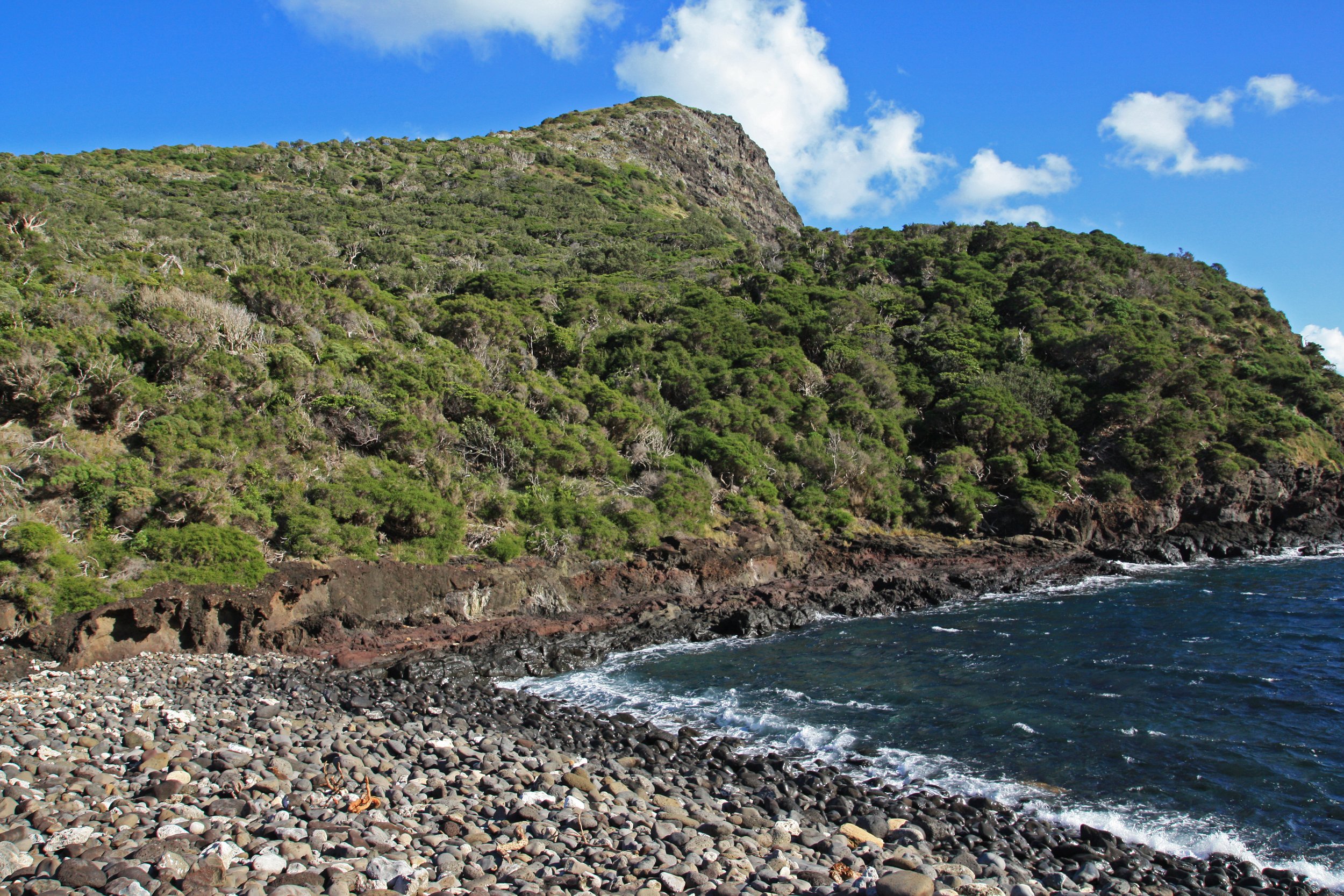
Coastline at Old Gulch with Mount Eliza beyond on Lord Howe Island, Australia.

Scrubbier forest at the northern tip of the island, with Mt. Eliza in the background.

Picturesque view across lagoon to dramatic peaks of Mount Gower and Mount Lidgbird on Lord Howe Island, Australia.

View across the island’s main lagoon, from near the northern end to Mts. Gower and Lidgbird.

Scenic view of Lord Howe Island, Australia, from summit of Mt. Gower.

View over the mist forest canopy and down the length of the island from the summit of Mt. Gower.

Refugium, oil on canvas, 48”x48” (2017).

Before I get to this latest map though…it’s actually my second work inspired by Lord Howe. The first, Refugium, was the last one of my oil paintings, which all had the same compression theme and multifaceted style as the watercolors but generally simpler compositions. In the foreground is the mist-forested summit of the island with a Lord Howe Island currawong, an endemic and endangered variety of its species. I hardly ever incorporate animals into my work but this one (seemingly not afraid of us) felt integral to the “lost world”-like atmosphere of the forest. The succulent desert in the upper left, at the far end of the island, and the transitional dry forest to the right of it are entirely inventedextreme idealizations, meant to create a more Galápagos-like level of ecological contrast, of the scrubbier landscapes in that zone.

In the new work, Perched (you’ll see that’s about more than the bird), I stuck with the landscapes as I found themthey’re diverse and evocative enough without any imagination. But the arid scenes in Refugium turn out to be relevant to some new developments in how I think conceptually about about all the worldviews, ideas that in Perched I’ve integrated deliberately for the first time.

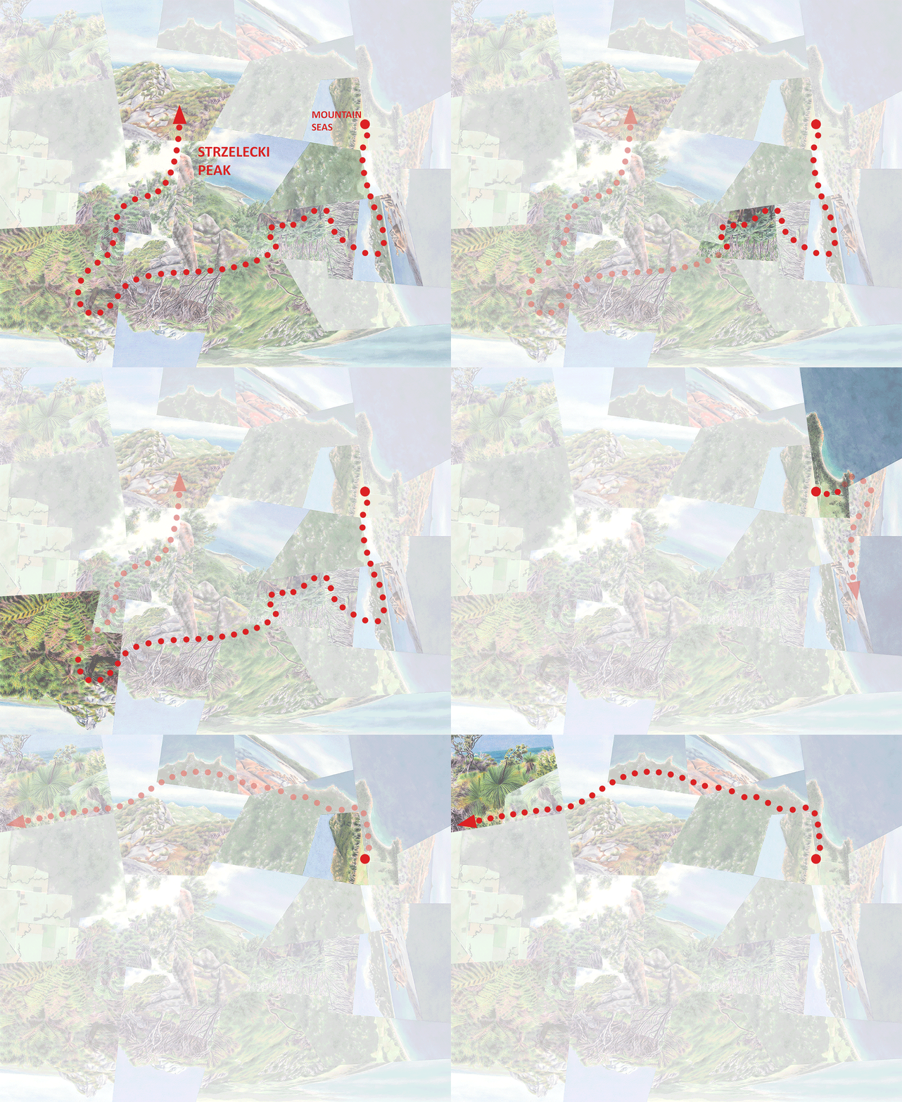
Lord Howe from above overlaid with my paths of travelalong roads and trails, on bicycle and on footthat I incorporated into Perched, extending outward from the main settlement.

Abstract watercolor painting of Lord Howe Island, Australia with bird, rainforest, mountains, and lagoon.

Perched, watercolor on paper, 52”x32.”

The travel paths as captured and distorted in the watercolor. A few segments are screened back to indicate they’re passing behind the elements pictured.

As I’ve written before, the “compression” theme across all the worldviews to varying degrees incorporates a quality of fragility and vulnerabilitya function of not just these places’ environmental uniqueness but also (especially in the case of oceanic islands) their particular susceptibility to accelerating environmental threats like climate change and invasive species. In both these works that delicacy applies in particular to the mist forest, reliant on regular moisture and, as the title implies, ecologically and evolutionarily isolated by less hospitable environments. In Refugium I meant the arid landscapes below the mist forest to be natural, but they could also suggest encroaching desertification caused by climate change. And while the form and character of the bird come directly from a photograph, to me it seems to be looking over at those arid fragments with a distressed expression.

I’ve realized that this feeling of impending doom reveals itself in all the worldviews to some extent if you look at them a certain wayagain sometimes in the content of the fragments (e.g. when they show cities or farmland) but more universally in the fragmented style itself. The fracturing could imply something completely opposite of the compressing, structuring, and freezing-in-place (“crystallizing”?) effect that it’s meant to have. It could also suggest instability, shattering, or disintegration, especially in the more recent, more highly fragmented watercolor maps. Again this second interpretation of the fragmentation has never been the original intent. But by the time I began Perched I did have it in the back of my mind, and about halfway through the painting process I decided to accentuate that “instability” factor in an additional way.

You’ll notice that the composition’s been turned roughly 90 degrees counter-clockwise from what would seem to be the most “natural” orientation. This is different from most of the worldviews, which typically don’t have one obviously “right” or “wrong” orientation since the components are already rotated in multiple directions (though usually one or two orientations do look more balanced than the others). This one looks rotated because, unlike all my previous maps where I used an overall aerial view as the “base” for the sketch that evolved into the final composition, Perched started with a view on the groundthe photograph shown above, looking down the length of the island from the summit. This particular perspective worked as that structural starting point because to a large extent it does provide a view of the overall geography like an aerial image would. But it has a very clear distinction between foreground and background which isn’t entirely erased after all the other views are pieced in, so there’s still an element of a foreground (the mist forest, with the bird) turned on its side. I decided that the rotation would heighten the suggestion of ecological instability and precariousness already created by the fragmentation. There also turns out to be a particular top-heaviness to the composition that adds to the sense of imbalance and imminent collapse. (And, the bird still has that distressed look….)

The title also reinforces this theme of instability. Perched refers literally to the bird but more broadly to a sense of the endangered mist forest clinging precariously (along with vertigo-plagued hikers) not just to the steep topography but to its very existence. And extending the metaphor it conveys the precariousness of the entire island, struggling to maintain its ecological balance.

I’ll have a lot more to say on these ideas about ecological fragility and change as the worldviews and this blog continue to evolve….

Darren

Perched, detail, mountains and mist forest.

Perched, detail, north end of the island and view back toward the peaks.

Summit

East Maui and Haleakala Crater.

Summit, my recently-completed watercolor map inspired by Haleakala Crater on Maui, is one of three works that I discussed in my October 2022 talk— In & On, Around & Above: Mapping Island Experiences—at the Annual Meeting of the North American Cartographic Information Society (NACIS). All of my worldviews are about conveying the intrinsically spatial experiences of islands of various forms, and this talk focused specifically on how this one and the other two, Oasis and Crystallize, capture insularity or “island-ness” in different ways. One consistent challenge was balancing perspectives of the island itself and of the surrounding environment, immersing the viewer on or “in” the island while at the same time emphasizing the island’s contrast with the world beyond. Since the interior of Haleakala Crater—an island in both an ecological and geological sense (that also just happens to be situated on an “actual” oceanic island)—is physically walled off from the exterior in most places, Summit involves a unique relationship between these components of immersion and contrast.
Probably 99% of visitors to Haleakala visit only the highest part of the rim—the “actual” summit (of Maui)—but a network of trails into and across the crater that typically takes three days and two nights (camping, or in cabins with advance reservations) to hike in full provides access to the interior. I did this trek back in 2016.

Haleakala Crater, enlarged.

At around 10,000’ above sea level most of the crater interior is alpine desert; this barren-ness combined with the clusters of cinder cones (the “crater” is in fact a caldera filled with many small craters) produces the feeling of being on a different planet.

Barren volcanic landscape with cinder cones and clouds in Haleakala Crater on the island of Maui, Hawaii.

Cinder cones near the center of the crater.

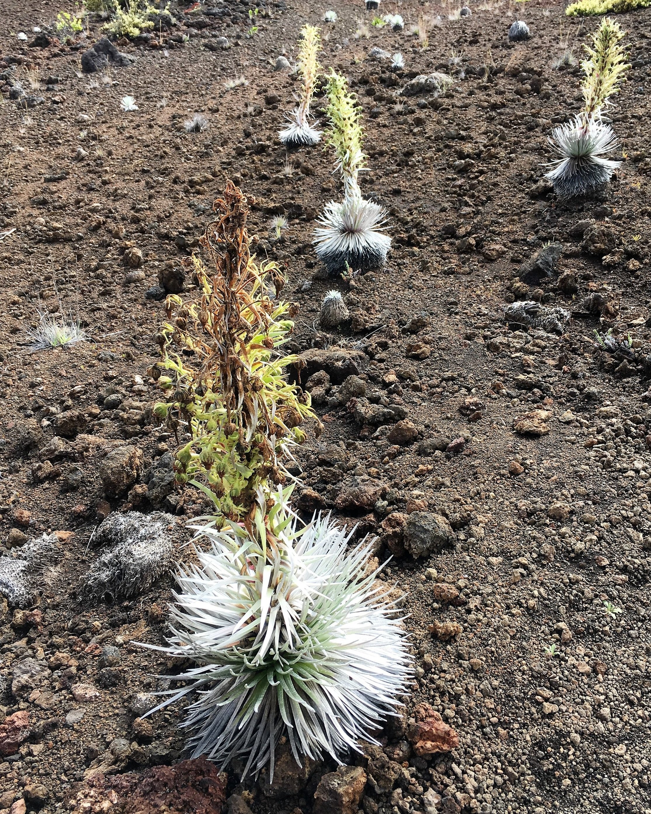
Endangered alpine silversword plants in Haleakala Crater on the island of Maui, Hawaii.

Endangered silverswords, unique to the alpine desert of Haleakala.

Parts of the northeastern side of the crater and crater rim, toward Maui’s windward side, have a less lunar character, with pockets native cloud forest vegetation that elsewhere on Maui only persist in inaccessible places. To the sense of the crater as a separate, special world unto itself, this element of ecological diversity adds the quality of being an “entire” world as well.

Lush rainforest vegetation in the Kaupo Gap in Haleakala Crater on the island of Maui, Hawaii.

Native cloud forest vegetation at the crater’s eastern edge.

Lush and misty eastern rim of Haleakala Crater on the island of Maui, Hawaii.

The lush eastern rim of the crater.

Inside the crater, the sense of being contained with a special, hidden world is of course reinforced by the crater rim—or, by the clouds that often hide or sit above it.

Red cinder cone and clouds in Haleakala Crater on the island of Maui, Hawaii.

A cinder cone in front of the crater’s dry southwestern rim.

Cloud-covered rim of Haleakala Crater on the island of Maui, Hawaii.

The slightly greener northwestern rim.

The two large gaps in the rim do give some hint of a world beyond, though at least when I was there the views were still mostly obstructed by clouds.

View through the Ko-olau gap at sunrise, above the clouds, in Haleakala Crater on the island of the Maui, Hawaii.

Early morning view through the Ko’olau Gap.

Cloud-covered rim of Haleakala Crater and view through Kaupo Gap on the island of Maui, Hawaii.

Looking along the eastern edge of the Kaupo Gap.

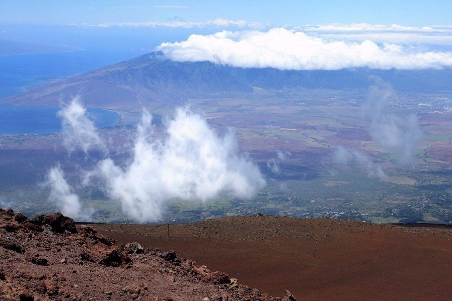
The rim itself is accessible only on eastern side at points along the access road, and clear, open views of the wider world are really only available from the main visitor area at the highest point. So it’s only from here that the striking contrast between two “worlds” is apparent—intensified by a kind of topographical illusion. I suspect I’m not the only person who finds it hard to believe that, thanks to the relative gentleness of shield volcano slopes, the summits of Maui and the Big Island are as high as the upper parts of the Sierra Nevada. The juxtaposition of the alpine landscapes of the Haleakala summit and crater with the lowlands of Maui beyond seems all the more dramatic as a result.

Overview of Haleakala Crater from the main visitor area.

View of Maui, Hawaii from barren rim of Haleakala Crater.

View westward from the Maui summit.

Ocean view from the alpine desert rim of Haleakala Crater on Maui, Hawaii.

This particular view looking south from the summit cuts out middle ground (the outer slopes of the volcano) completely, so that the ocean looks as if it were only a few hundred feet below. (In the distance are the peaks of Mauna Kea and Mauna Loa on the Big Island.)

Traveling through the more familiar landscapes of the Maui lowlands, the special world of the crater is similarly out of sight and out of mind.

Lush rainforest along boardwalk near Waimoku Falls in Haleakala National Park on the island of Maui, Hawaii.

Semi-native rainforest along the trail to Waimoku Falls, in the coastal section of Haleakala National Park.

View of Haleakala mountain in the clouds from the coast of the island of Maui, Hawaii.

Looking at Haleakala from the coast, not only is the crater physically invisible; as with the impression standing on the summit, the gradual slopes make it hard to believe that the mountaintop is above the tree line.

In the initial digital mockup for the watercolor map, the form of the crater—and therefore the sense of immersion within and of contrast with the world beyond—doesn’t read very well. The problem is a combination of too many fragments and a lack of uniformity of light and color between them.

Abstract digital photomontage of Haleakala Crater on the Island of Maui, Hawaii.

The watercolor would need to focus more on the crater itself (eliminating a few of the views from beyond) and call more attention to the rim by evening out the colors and playing with the shadows. (Interestingly the “horizon lines” of the gaps in the rim read as continuations of the rim itself, which would help to emphasize the sense of enclosure.)

I’m pretty happy with the outcome (below), but since my visit predated this current style of map, I’d really like to return and be more deliberate about collecting imagery. (Fortunately I took plenty of photos the first time, but there were some missing pieces that I ended up filling with google imagery or eliminating with compositional distortions.) In fact the National Parks Arts Foundation offers a paid artist residency in this (and other) national parks that I have been trying for…hopefully someday I’ll get lucky.

Darren

Abstract watercolor painting of Haleakala Crater on the island of Maui, Hawaii.

Summit, watercolor on paper, 39”x52.”

Summit detail, desert zone.

Summit detail, rainforest zone.